Keeping, perhaps, with its "pocket park" size, 76,519-acre (30,966-hectare) Arches specializes in short- to medium-length hikes. But they all have big payoffs.

But you have to remember, you're in the desert, and for many, at elevation (4,035 feet / 1,229.9 meters at the visitor center is the low point), so you have to pace yourself and be prepared to meet your body's needs as you hike. That means plenty of water, a wide-brimmed hat to protect your face and neck from the sun, sunscreen for any and all exposed skin, and sunglasses to cut the glare.
Outside of the trails that start and end at Devils Garden, you won't find any water taps beyond the park's visitor center, so plan accordingly. At Devils Garden, there's water at the trailhead where you can top off any water bottles or hydration packs you have.
Once adequately prepared, the next question is where to go? The answer, of course, boils down largely to how much time you have, for just about any hike you choose will be rewarding with incredible scenery.

Landscape Arch, Arches National Park
Kurt Repanshek Photo
Walk along the backs of fins, search for potholes, explore the sandy washes. Delicate Arch should be experienced only by hiking to its location, not by opting for the viewpoint reached by autos. Klondike Bluffs might look distant on the map, but it's worth the trek. And it would be a shame not to explore the Fiery Furnace.
Between the visitor center and Devils Garden you'll come upon three main hiking areas: Park Avenue, where a mile-long trail leads through a very impressive, steeply walled canyon; Balanced Rock and the Windows Section, and; Delicate Arch. All deserve your attention. Beyond those areas, there are a handful of less-famous trails that will offer equally beautiful scenery as well as the potential for more solitude.
For a great, half-day backcountry hike, hike beyond Landscape Arch, past Navajoa Arch and the rubble that remains after the collapse in 2008 of Wall Arch, all the way to Double O and the Dark Angel, and then take the primitive trail back. Just be sure to carry water and snacks.
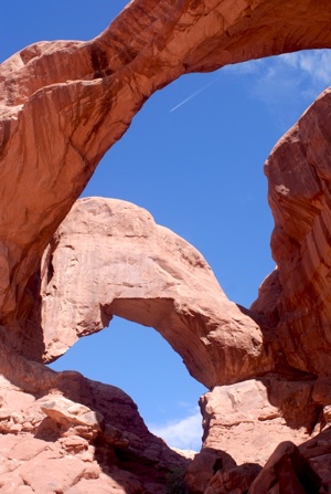
Double Arch in the Windows Section.
Kurt Repanshek photo
Arches' Hikes Featured On the Traveler
Windows Section
* You don't need to be a long-distance hiker to tackle what arguably is not just the shortest but also the most impressive hike at Arches. A comfortable pair of shoes, a bottle of water, and perhaps 90 minutes of your time will be enough to explore the Windows Section of the park. While most folks are in a hurry to see Delicate Arch or Landscape Arch, the collection of unusual formations in Windows Section make it a mandatory stop if you've traveled all the way to this southeastern Utah park.
You can find the rest of the story on this page.
Primitive Loop Trail
* There might be no finer time to hike in Arches than early mornings, when the soft light of the rising sun glints off red-rock and spindly Utah junipers and waves of sandstone fins cast long shadows. While many visitors to Arches seem perfectly satisfied to make the 30-minute walk from the Devils Garden parking area to admire Landscape Arch, and more than a few embark on 4-mile (6.4-km) roundtrip to Double O Arch, only a handful or two endeavor to explore the 7.2-mile (11.59) Primitive Loop that climbs and drops across this incredible landscape.
You can find the rest of the story on this page.
Here's a look at other hikes in the park, courtesy of the National Park Service:
Easy Hikes
Balanced Rock
Starting Point: Balanced Rock parking area
Length: 0.3 mi/0.5 km round trip
Time: 15 to 30 minutes
A loop trail around the base of a fragile, picturesque rock formation.
Broken Arch
Starting Point: Sand Dune Arch parking area or Devils Garden campground across from campsite #40
Length: 1.2 mi/2 km round trip; 2 mi/3.2 km including the loop
Time: 30 to 60 minutes
From the Sand Dune Arch parking area, the trail cuts across a large meadow to the arch and continues to the campground. Loop trail leads through fin canyons with sand dunes and slickrock.
Delicate Arch Viewpoint
Starting Point: Delicate Arch Viewpoint parking area
Length: 100 yards (91 meters) round trip
Time: 10 to 15 minutes
In addition to the short accessible trail, another (moderately strenuous) hiking trail climbs one-half mile (0.8 km) toward Delicate Arch and ends at the rim of a steep canyon that separates the viewpoint from the arch. (This is not the popular trail to Delicate Arch, which starts at the Wolfe Ranch parking area.)
Double Arch
Starting Point: Double Arch parking area
Length: 0.5 mile (0.8 km) round trip
Time: 15 to 30 minutes
A relatively flat, sandy trail leads to the base of two giant arch spans which are joined at one end.
Landscape Arch
Starting Point: Devils Garden trailhead parking area
Length: 2 miles (3.2 km) round trip
Time: 30 to 60 minutes
A relatively flat, gravel-surfaced trail (usually heavily populated with hikers) leads to a spectacular ribbon of rock, whose span is more than a football field in length. Short side trips to Tunnel and Pine Tree Arches. Trail guide available at trailhead.
Sand Dune Arch
Starting Point: Sand Dune Arch parking area
Length: 0.4 mile (0.6 km) round trip
Time: 15 to 30 minutes
Trail leads through deep sand to a secluded arch among sandstone fins.
Skyline Arch
Starting Point: Skyline Arch parking area
Length: 0.4 mile (0.6 km) round trip
Time: 10 to 20 minutes
A short hike on a flat, well-defined trail. On a cold November night in 1940, a large chunk fell out of the arch, instantly doubling the size of its opening.
The Windows
Starting Point: Windows parking area
Length: 1 mile (1.6 km) round trip
Time: 30 to 60 minutes
A gentle climb up a gravel loop trail leads to three massive arches (North and South Windows and Turret Arch). An alternate return, slightly longer, is by way of the primitive loop around the back of the two Windows. The primitive loop trail starts at the South Window viewpoint.
Moderate Trails
Starting Point: Park Avenue parking area
Ending Point: Courthouse Towers parking area
Length: 1 mile (1.6 km) one way
Time: 30 to 60 minutes
Elevation change: 320 feet (98 meters)
From Park Avenue parking area, the trail descends steeply into a spectacular canyon and continues down the wash to Courthouse Towers. If you have a shuttle driver, you can begin at one point and be picked up at the other. For round-trip hiking, retrace your steps along the trail rather than walk along the park road.
Tower Arch
Starting Point: Klondike Bluffs parking area, via the Salt Valley road
Length: 3.4 miles (5.6 km) round trip
Time: 2 to 3 hours
The trail climbs a steep, but short, rock wall, cuts across a valley and then meanders through sandstone fins and sand dunes. An alternate, shorter trail (0.3 mile [0.4 km] one way), begins at the end of the four-wheel-drive road on the west side of Tower Arch. This unpaved road washes out quickly in rainstorms; inquire at the visitor center about road conditions before heading out.
Long Trails
Starting Point: Wolfe Ranch parking area
Length: 3 miles (4.8 km) round trip
Time: 2 to 3 hours
Elevation change: 480 feet (146 meters)
Take at least 1 quart (1 liter) of water per person! There is no shade. Open slickrock with some exposure to heights. The first half-mile (0.8 km) is a wide, well-defined trail. Upon reaching the slickrock, follow the rock cairns. The trail climbs gradually and levels out toward the top of this rock face. Just before you get to Delicate Arch, the trail goes along a rock ledge for about 200 yards.
Devils Garden Primitive Loop
Starting Point: Devils Garden Trailhead parking area
Length: 7.2 mi/11.5 km round-trip, including all points of interest
Time: 3 to 5 hours
Longest of the maintained trails in the park, the Devils Garden Trail leads to eight awe-inspiring arches. Expect narrow ledges with rocky surface hiking and scrambling on slickrock. Not recommended when rock is wet or snowy. Trail guide available at trailhead.
Double O Arch
Starting Point: Devils Garden Trailhead parking area
Length: 4 miles (6.4 km) round trip
Time: 2 to 3 hours
Beyond Landscape Arch, the trail becomes more challenging as it climbs over sandstone slabs; footing is rocky; there are narrow ledges with exposure to heights. Spur trails lead to Partition and Navajo Arches. Dark Angel is one-half mile (0.8 km) farther. Trail guide available at trailhead.
Fiery Furnace
The Fiery Furnace is a labyrinth of narrow sandstone canyons and fins. There are no marked trails and the area has suffered resource damage due to increased visitation. Hikers who want to explore the Fiery Furnace must obtain a permit at the visitor center (fee charged) and watch a minimum impact video. All visitors are encouraged to sign up for a ranger-guided hike.


