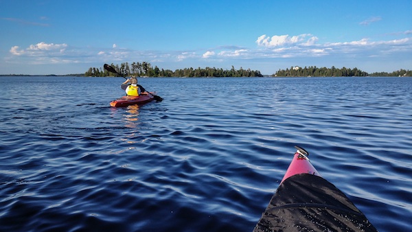
Rainy Lake offers day after day after day of paddling adventures. Jeff Kantor photo.
Of Minnesota's fabled 10,000 lakes, none are so pristine, so haunting, so alluring to anglers, boaters, and campers as the rock-ribbed lakes of the north woods, where the cry of loons and howl of wolves soar over the gray water. The wildest and most beautiful of all are the thousands of lakes, large and small, sprinkled along Minnesota's border with Canada, the location of Voyageurs National Park.
As national parks go, Voyageurs is unusual'as much as water as land. Nearly 40 percent of its 218,054 acres consist of four huge lakes: Sand Point, Namakan, Kabetogama, and the giant Rainy, which stretches some 50 miles long, deep into Ontario.
Voyageurs was named for the fur-trading French Canadians who paddled their 26-foot canots du nord down these lakes 200 years ago to reach the interior of North America. Yet the honor gives short shrift to the Ojibwe Indians who traveled these waterways for thousands of years, probably well before the advent of the birch-bark canoe, in pine-log dugouts.
So, if you choose to explore Voyageurs in a canoe, you're in good company. But even the voyageurs got wind-bound. Up here, the ideal paddle craft is a sea kayak. On the large lakes of Voyageurs, you can paddle for days over more than 60 miles of interconnected waterways with only a single portage at Kettle Falls. Even as large as Rainy Lake is'some 50 miles in length (reaching far into Ontario)'an experienced kayaker can navigate the lake in all but the worst windstorms.
Paddling in Voyageurs brings incredible solitude, and great fishing, as the author has discovered time and again. Susan Binkley photo.
The shorelines of these big lakes are tangles of bays, points, and channels. The big lakes have more than 500 islands and 600 miles of shoreline. Paddling inattentively for a half-hour, you can get thoroughly turned around. Of course, a GPS will set you right. In fact, you can download waypoints for campsites and day-use sites. But I still like an old-fashioned map and compass, which force me to keep a watchful eye on the changing kaleidoscope of lake and shoreline.
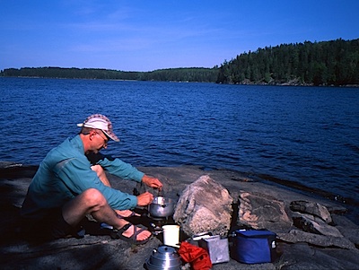
Hundreds of tent sites and picnic areas dot the shore. (Thirty campsites can be reserved. The rest are open to whomever shows up first.) Wherever you camp, black bears will be nearby. Stash food in the steel lockers. If you're camping at a site without a locker, the standard advice is to hang food and anything else that might smell like food from a high branch or suspended between two trees.
This land is wild, but it's hardly untouched. You might spot several remnants of the past. A gaping hole on rocky Bushyhead Island is the shaft of an gold mine opened and abandoned more than a century ago. A 6-inch iron ring sunk in the outcrop deep in Lost Bay on Kabetogama Lake anchored a boom that corralled sawlogs. Pilings on Hoist Bay date to the area's logging era.

This is the comment.
Most notable is the Kettle Falls Hotel, built a century ago where Namakan plunges into Rainy. Once a popular meeting place of loggers, prospectors, bootleggers, and prostitutes, the hotel has been visited by such luminaries as Charles Lindbergh, John D. Rockefeller and several members of Congress. Renovated by the National Park Service in 1987, it's open for lodging, dining, and drinking.
When to visit? Early summer is probably best for fishing. Try mid- to late summer to avoid mosquitoes and to go swimming. Early fall, when a tinge of yellow colors the aspen, is a magic time. There are fewer boaters on the water. You'll have your pick of camp- sites. Even the uneven autumn weather can be a plus. When clouds and mist cover the lakes, the landscape seems its most elemental. Dodging among the black islands in a kayak, quite often you share the lake only with yourself.
Story Categories:
A copy of National Parks Traveler's financial statements may be obtained by sending a stamped, self-addressed envelope to: National Parks Traveler, P.O. Box 980452, Park City, Utah 84098. National Parks Traveler was formed in the state of Utah for the purpose of informing and educating about national parks and protected areas.
Residents of the following states may obtain a copy of our financial and additional information as stated below:
- Florida: A COPY OF THE OFFICIAL REGISTRATION AND FINANCIAL INFORMATION FOR NATIONAL PARKS TRAVELER, (REGISTRATION NO. CH 51659), MAY BE OBTAINED FROM THE DIVISION OF CONSUMER SERVICES BY CALLING 800-435-7352 OR VISITING THEIR WEBSITE. REGISTRATION DOES NOT IMPLY ENDORSEMENT, APPROVAL, OR RECOMMENDATION BY THE STATE.
- Georgia: A full and fair description of the programs and financial statement summary of National Parks Traveler is available upon request at the office and phone number indicated above.
- Maryland: Documents and information submitted under the Maryland Solicitations Act are also available, for the cost of postage and copies, from the Secretary of State, State House, Annapolis, MD 21401 (410-974-5534).
- North Carolina: Financial information about this organization and a copy of its license are available from the State Solicitation Licensing Branch at 888-830-4989 or 919-807-2214. The license is not an endorsement by the State.
- Pennsylvania: The official registration and financial information of National Parks Traveler may be obtained from the Pennsylvania Department of State by calling 800-732-0999. Registration does not imply endorsement.
- Virginia: Financial statements are available from the Virginia Department of Agriculture and Consumer Services, 102 Governor Street, Richmond, Virginia 23219.
- Washington: National Parks Traveler is registered with Washington State’s Charities Program as required by law and additional information is available by calling 800-332-4483 or visiting www.sos.wa.gov/charities, or on file at Charities Division, Office of the Secretary of State, State of Washington, Olympia, WA 98504.
Comments
My wife and I spent a day trolling around Voyageurs in a motor boat. At the end of the day I looked at the map and was surprised how little of it we saw, even under power. It definitely seems like a great place to get lost for a week or more by kayak, canoe, or on foot. So many little coves and hideaways to discover.