Crater Lake is a land of extremes, from the striking beauty of Wizard Island, in summer and winter, to dramatic sunsets, pine-covered hillsides and volcanic spires. Photos courtesy of, and copyrighted by, QT Luong (first, fourth and fifth), www.terragalleria.com/parks, and Rob Mutch, (third and fourth).
Despite its deep, shimmering namesake lake, Crater Lake National Park is one of the lesser visited of the great national parks (446,516 recreational visits in 2009). For those who make the journey, that's a great reward. For those who don't, well, they're missing something special.
Why should anyone consider driving out onto the crest of the Cascade Mountains in southern Oregon to see Crater Lake? Well, there are many reasons.
The caldera of Crater Lake gives a park visitor the chance to look into the inside of a volcano that was once possibly as high as Mt. Hood or Mt. Adams. Just to stand there and consider the geologic events that made this landscape and created the great caldera, now nearly half-filled by the lake, is worth the journey.
Birth Of A Lake
The mountain that stood in the place of what is now Crater Lake has been given the name Mt. Mazama (after the Portland, Oregon, hiking club of the same name). Although the oldest volcanic rocks of Mt. Mazama are estimated at more than 400,000 years old, just some thousands of years ago the mountain underwent a series of volcanic eruptions which eventually emptied out the magma chamber beneath the mountain, creating a huge inner void.
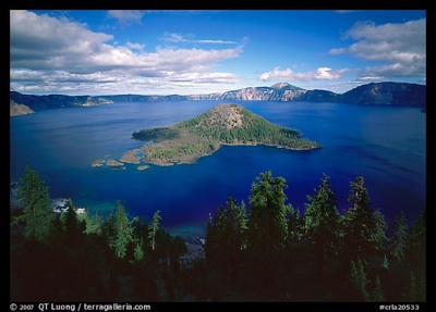
The outer slopes of the mountain could no longer support the weight of the summit rocks, causing the top 3,000 to 4,000 feet of the volcano to collapse inward. This violent collapse formed a 4,000-foot deep, 6 mile by 4.5 mile-wide bowl-shaped depression, now nearly half-filled by very pure water. The water of Crater Lake comes almost entirely from direct precipitation. No streams flow into or out from the surface of the lake.
Crater Lake is the deepest lake in the United States and the 9th deepest lake in the world. Less well known is the fact that its average depth is the greatest of any Western Hemisphere lake and exceeds that of all but two other lakes in the entire world. No lake whose basin is entirely above sea level has a greater average depth.
Along with a chance to ponder the cataclysmic event that caused the destruction of Mt. Mazama -- so powerful were the explosions that some ash later was discovered in Antarctica -- a tour of the park provides you with an introduction to the formation of the stratovolcanoes of the high Cascades. From the rim of the caldera, views may extend along the crest of the Cascades to snow-covered Mt. Shasta in northern California to the Three Sisters near Bend, Oregon.
The roadways and creek valleys expose volcanic materials deposited as glowing avalanches of pumice, ash, and dense hot gases that emanated from the volcano during its final hours. In many places, water has eroded though these thick deposits of glowing avalanche debris to depths of a few hundred feet, exposing multicolored cliffs of hardened ash and the remains of hundreds of vertical pinnacles of hot gas-cemented fumaroles.
Charcoal remains of incinerated tree stumps can be found in road cuts. Radioactive carbon dating of these tree stumps, along with dendrochronological refinements based on comparison of radioactive carbon dating against cores of tree rings sampled from the ancient bristlecone pines of California’s White Mountains, led to the eventual determination of the age of the formation of Crater Lake’s caldera of 7,700 years ago (plus or minus a few hundred years).
Getting Out and Enjoying the Park
Fascinating geology aside, perhaps the No. 1 reason to visit Crater Lake is its immense beauty, duplicated nowhere else on Earth and captured so inadequately by photographs. Although the majority of park visitors take less than one day to visit, with most limiting their stay to a few hours, my friends and I would highly recommend reserving at least three days (if not more) to see this park. During these three days, here are the things I recommend to see and do:
* Rise very early and drive to or walk along the rim of the great caldera to experience the change of color just before, during, and after sunrise. My favorite spot for watching sunrise over the caldera are Discovery Point, the Watchman overlook, or anywhere along the Rim Village promenade.
* Stop during the day and listen to the short introductory story about the formation of Crater Lake. This talk is given by park interpretive rangers at the Sinnott Memorial Overlook. This stone overlook offers classic views of the inner caldera and is the only place along the Rim Village promenade to view the Phantom Ship. The overlook is reached by a descending path just below the Kiser Studio, a small rustic wood and stone single-standing building between the cafeteria/giftshop complex and the Crater Lake Lodge. Check the park newspaper, Reflections, or at the Kiser Studio for exact times for these short but highly informative presentations.
* Make reservations in advance with Xanterra Parks & Resorts to take the approximately 90-minute ranger-narrated boat tour from Cleetwood Cove. You reach the dock via a 1.1-mile trail that drops 700 feet to the lake’s shore from a parking area that is on the opposite side of the caldera from Rim Village. Boat tours usually operate between early July and early Sept. Remember that the hike back up and out of the caldera after you end the boat tour will take from two to three times as long as the hike down. (Be sure to take and apply lots of sunscreen. Exposure to the sun is intense due to reflection from the lake surface.)
Be sure to check with Xanterra or park staff about their most recent policy regarding interrupting boat tours to hike and explore Wizard Island. If you take an early-day boat tour, and can get off onto Wizard Island, and if there is no difficulty reserving a return boat from the island, be sure to take the hike up and into the summit crater. If time allows, explore the transparent green emerald pools on the western flank of the island. The views are well worth the effort.
Wizard Island is a cinder cone initially formed by volcanic eruptions that occurred after the climactic events that caused the collapse of Mt. Mazama. The cinder and lava eruptions that formed Wizard Island began below the surface of the young lake. The summit crater of Wizard Island is about 300 feet across and 90 feet deep. There are two other cinder cones inside Crater Lake’s inner caldera, but they are invisible because they were formed entirely below the lake’s surface.
* Fishing is allowed off the shores of Wizard Island as well as from Cleetwood Cove. No license is required, and there are no limits. All fish (mostly kokanee salmon and rainbow trout) were artificially planted in Crater Lake between 1888 and the early 1940s.
* If you happen to be in the park during the time of the full moon, I definitely recommend a late afternoon hike to the Watchman Firelookout. It’s the only fire lookout on the rim of the caldera. Stay for sunset. Watch the shadow of the Watchman slowly engulf Wizard Island below, and then extend across the lake to the opposite shore as the sunsets. Watch the moon rise from the eastern horizon. You can almost feel the Earth in motion.
If there’s no moon, it’s still worthwhile to watch sunset from the Watchman. And anywhere along the rim is perfect for star gazing. From the edge of the rim, you will experience horizon to horizon of stars. Dress warmly, as temperatures drop at night. You might encounter someone out with a telescope. They might even enjoy sharing knowledge and equipment. Try not to shine any lights in their eyes.
* Other day hikes I would recommend are Garfield Peak; its trailhead is the Rim Village promenade just east of Crater Lake Lodge. This is perhaps the most popular hike in the park. On some days of the week, the rangers offer guided walks to the top.
The somewhat longer hike to the summit of Mt. Scott, which has park’s only other fire lookout and is the highest elevation in the park (8,929 ft.), is also spectacular with wide views into the upper Klamath basin, the Crater Lake caldera immediately below, and the sharp eroded summit of Mt. Thielsen, an older shield-type volcano to the north, just beyond the park’s northern boundary. The trailhead to Mt. Scott is found along the eastern portion of the 33-mile Rim Drive.
These hikes may be dangerous when covered by snow. Do not venture over snow fields. These hikes are usually free of snow from about mid-July until mid-October.
Shorter hikes include the Castle Crest Wildflower Garden, located near park headquarters and the junction of the eastern rim drive, and the Annie Creek Trail, which starts at the F loop of the Mazama Campground, located 7 miles south of the rim, near the park’s south entrance station.
* A great off-trail experience is to drive out towards the North Entrance and hike out onto the Pumice Desert. Here the pumice flats are so porous and deep that water drains away quickly, leaving little opportunity for vegetative growth. Many types of volcanic rocks can be found while walking through the pumice desert, including volcanic bombs from nearby cinder cones. Mt. Thielsen dominates the northern horizon. Walking out into the Pumice Desert requires a hat, dark glasses, and sunscreen. .
* No visit to Crater Lake National Park is complete without driving the 33-mile Rim Drive. I recommend taking this drive in clockwise direction, meaning that views of the inner caldera will always be on the right side of the road. “Must see” stops along this drive are (a) Discovery Point, (b) the Steel Bay overlook (with corral-like wooden log railings) located in the saddle between Watchman and Hillman Peak, (c) the North Junction overlook with views of Llao Rock and the Devils’ Backbone, (d) Cleetwood Cove, (e) Cloud Cap (the highest elevation along the drive), (f) the Pumice Castle overlook, (g) Kerr Notch (with spectacular views of the Phantom Ship and the Chaski Slide), and (h) Sun Notch (with a “must do” short hike from the parking area, across a pumice field of wild flowers, that leads to edge of Sun Notch and a spectacular close-up view of the Phantom Ship and the western face of Dutton Cliff).
The Crater Lake Natural History Association sells guides to this historic road. Another recent option, introduced just last summer, is to take a ranger-guided trolley-like tram tour of this drive. This method of taking the Rim Drive allows one to keep the car parked in the Rim Village parking area and letting someone else do the driving (inquire about prices with Xanterra).
If you elect to self-drive the Rim Drive, one advantage is the option to take the spur road past the Lost Creek Campground, along what was once the East Entrance to the park, to the Pinnacles of Sand Creek. These towering needle-like formations of rock, called fossil fumaroles, projecting from the Sand Creek Canyon floor, were formed by sheets of volcanic pumice and glowing avalanches that immediately preceded Mazama's collapse.
As the surface of the hot pumice cooled, steam and gases were released by the hot rocks underneath through vents and tubes. The ash and pumice were thermally altered and welded into cement hardness by the passage of hot gases through these vents. These ancient vents now stand alone due to the erosion of the surrounding softer materials. I would rate the Pinnacles of Sand Creek as another “must see” experience during a visit to Crater Lake National Park.
Depending on whether you elect to stay inside the park or overnight outside, you may wish to take in an evening ranger program. Most evening programs are offered at the Mazama Campground Amphitheater during the summer months. Some programs may be scheduled at the Community House located at Rim Village. Check with the Steel Visitor Center at Park Headquarters or at the Kiser Studio at Rim Village for times and subjects.
* Lodging at Crater Lake Lodge on the Rim and at Mazama Village Motor Inn typically require reservations far in advance. Both facilities are managed by Xanterra, Inc. Check with Xanterra for prices. Outside park accommodations are found at Diamond Lake Lodge in the north, Union Creek in the west, and in or near Fort Klamath in the south east of the park. However, the only winter lodging in Fort Klamath is at Jo's Motel on four-day weekends. We’ve had very good experiences at the historic Prospect Hotel on the west side, where people going to Crater Lake have been staying there for many years, and at the Aspen Inn (Ft. Klamath) for southwest side park lodging. The inn reopens in April.
Camping in the park is at the large Mazama Campground (equipped for RVs and tents), or at the more primitive Lost Creek Campground (tents only).
Resources
Crater Lake National Park ; (541) 594-3000
Crater Lake Natural History Association ; (541)594-3110
Crater Lake Institute ; (541) 810-3944
Owen Hoffman is a frequent contributor to articles and commentary in Traveler. He worked at Crater Lake earlier in his career as both a park ranger-naturalist and a lake researcher. More recently he has served the NPS at the park as a park volunteer. He is currently a member of the Board of Directors of the Crater Lake Institute.
Story Categories:
A copy of National Parks Traveler's financial statements may be obtained by sending a stamped, self-addressed envelope to: National Parks Traveler, P.O. Box 980452, Park City, Utah 84098. National Parks Traveler was formed in the state of Utah for the purpose of informing and educating about national parks and protected areas.
Residents of the following states may obtain a copy of our financial and additional information as stated below:
- Florida: A COPY OF THE OFFICIAL REGISTRATION AND FINANCIAL INFORMATION FOR NATIONAL PARKS TRAVELER, (REGISTRATION NO. CH 51659), MAY BE OBTAINED FROM THE DIVISION OF CONSUMER SERVICES BY CALLING 800-435-7352 OR VISITING THEIR WEBSITE. REGISTRATION DOES NOT IMPLY ENDORSEMENT, APPROVAL, OR RECOMMENDATION BY THE STATE.
- Georgia: A full and fair description of the programs and financial statement summary of National Parks Traveler is available upon request at the office and phone number indicated above.
- Maryland: Documents and information submitted under the Maryland Solicitations Act are also available, for the cost of postage and copies, from the Secretary of State, State House, Annapolis, MD 21401 (410-974-5534).
- North Carolina: Financial information about this organization and a copy of its license are available from the State Solicitation Licensing Branch at 888-830-4989 or 919-807-2214. The license is not an endorsement by the State.
- Pennsylvania: The official registration and financial information of National Parks Traveler may be obtained from the Pennsylvania Department of State by calling 800-732-0999. Registration does not imply endorsement.
- Virginia: Financial statements are available from the Virginia Department of Agriculture and Consumer Services, 102 Governor Street, Richmond, Virginia 23219.
- Washington: National Parks Traveler is registered with Washington State’s Charities Program as required by law and additional information is available by calling 800-332-4483 or visiting www.sos.wa.gov/charities, or on file at Charities Division, Office of the Secretary of State, State of Washington, Olympia, WA 98504.
Comments
I am so glad to finally see a really long and indepth article about Crater Lake. I live approximately 1.5 hours from the Lake and spend as much time there as possible during the year. I try to make a "winter" trip (which I will be doing this week) and then several trips for hiking and photography from July 1st to when the snow flys. That can be anywhere from September to November. I have hiked to the top of Mount Scott on October 28th a couple years ago. Last year, the snow started early, so October 1st was my last trip.
It was also nice to see a photo of the Pinnacles included in your article. Most folks that do visit the Lake never take the time to drive the 14-mile round trip to see the Pinnacles. Being and amateur photographer, the Pinnacles need to be visited twice during the day. First in the early morning light and then in the late afternoon. You definitely get two perspectives of those beautiful towers.
Another place that needs to be seen is the Lakes edge. Of course, that is a strenuous hike back up the caldera wall, but the only place that you can actually reach the waters edge. You can also swim and S.C.U.B.A. diving from this same location. Cleetwood Cove is so beautiful, that this needs to be a destination for everyone.
Thank you again for this wonderful article. Maybe this summer and fall the park will see more visitors.
The most distant geographic location ancient Mt. Mazama volcanic ash has been identified is in
Antarctica ice cores during a three year period when high altitude fine ash was finally deposited.
http://www.bibliotecapleyades.net/antarctica/antartica08b.htm
The 7,700 year calendar year date for Mt. Mazama's climactic eruption is the newer tree ring
corrected date whereas the often quoted 6,850 date is
the original radiocarbon date prior to the tree ring correction curve research which tested
precisely dated ancient bristlecone pine wood samples of known age. Ancient Bristlecone pines
are truly The Trees which Rewrote History.
Thanks, Owen, for a very nice article on the park. One of our objectives is to educate the public that although the park was created to protect and preserve the lake and its environs, Crater Lake is truly a national park in every sense with spectacular scenery, fascinating botany, abundant wildlife, and wonderful recreational opportunities. Please add to your list of "short" trails the new Plaikni Falls Trail, officially opening in the summer of 2011. This easy and accessible two mile, round trip trail is in the lesser used eastern part of the park just off of the Pinnacles Road. The trail meanders through a level, mixed mesic forest past the sheer cliffs of Anderson Bluffs and ends in a lovely, lush riparian area with a beautiful small waterfall and a profusion of wildflowers (in season, of course.) It will be an excellent addition to the other wonderful hikes in the park. The Rim Drive is truly a world class experience that should not be missed. However, we hope in coming years to work to provide opportunities to visitors so they may discover that there is more to Crater Lake than a 33 mile scenic drive. Articles like yours are helping us to spread the word!
Thanks Craig,
It's a pleasure to write this article and have the park's superintendent comment and offer additional information. I will have to make the new Plaikni Falls Trail, a "must see" on my own list for my next visit. It's great to have you at the helm at Crater Lake, which to many of us is a most sacred place.
For those that seek a little faster movement around the Rim while still on your feet, there is a Marathon, Half Marathon and 6.7 mile race every August. It is a pretty difficult event because of the 7,000+ feet elevation and few big name runners participate because of generally poorer times compared to sea level events. Not a bad thing to take it slow at such a spectacular place:).
Hi Owen,
Nice overview! I've wrote a series of stories (with video) about the park last summer and didn't even get to the rim until January. There are a lot of things to do and places to go beyond the rim. Anyway, check them out at:
http://explore.globalcreations.com/category/places/usa/klamathbasin/crat...
-Jerry-
Jerry, Thanks for posting your link to an excellent series of articles and video on some of the more subtle adventures associated with a visit to Crater Lake National Park. I especially enjoyed reading your article on Llao's Hallway. This hike is not for the unprepared. A hard hat, sturdy boots, and gloves are definitely recommended. The lower Hallway can be dangerous, especially when there's still snow in the narrow slot canyon. By July, and even into August, there may still be hardened snow clogging the narrowest portion of the lower Hallway. This snow will have been hollowed out by the water of Whitehorse Creek and is thus susceptible to collapse on or under a hiker. Hiking down into the Hallway while there is still snow present is not recommended.
On our one and only trip (so far) to Oregon/Washington for a conference, we were fortunate enough to be able to rent a car and travel for 10 days. Our main objectives were Olympic NP, Mt. Rainier NP, Mt. St. Helens, and Crater Lake NP. What a life changing trip that was. The beauty is magnificent. The drive over to Crater Lake was unforgettable and gorgeous. What we didn't count on was the number of visitors in the park that day and the fact that the lodge was totally booked so we didn't get to spend as much time in the park as we had wanted to. We did drive around and I think we hit all the roads and took a few short walks. Had dinner at the lodge and sat on the back porch admiring the view which truly can't be described with words or pictures. You have to see to appreciate. Thanks to everyone who keeps our parks safe and gorgeous for us to be able to enjoy.
I have been to 3/4 of our National Parks throughout my lifetime, so I have experienced a lot of natural beauty. I made the effort to go to Crater Lake 2 summers ago for the first time. When we pulled over to look at the lake for the first time, I simply stood there and cried. This is the most beautiful place on the face of the earth, as far as I am concerned. I didn't have a ton of time there, but I did do a few small trails that day. I kept coming back to the rim to see the most magnificent blue water I have ever seen. Words and photos can never describe this place. If you are reading this and thinking about making the trip, do. I will never forget this breathtaking scene as long as I live.
Great article.
Of all the parks I have been to in my life, this is the one park I go to over and over again. It is spectacular! And the area of Klamath County has so much to offer, something for everyone. We took the kids again last summer and they loved the lava tubes, hiking the rim of Crater Lake, kayaking and seeing all those birds. Besides the Crater Lake National Park website, you may want to check out the Discover Klamath website. DK really helped us find campsites and their courteous staff was most helpful.
Mr. Hoffman, Thank you for your wonderful article on the only National Park in Oregon. We here in Klamath County are proud of this iconic resource in our backyard and also take every opportunity to share its beauty in the marketing of our County. I want to add a couple points to your otherwise thorough review. First, for people wishing to fly into the area, Klamath Falls Regional airport is the place to go. The airport code is LMT and is serviced by United/Skywest Airlines. We also have Amtrak which stops in both the City of Klamath Falls, and, Chemult, Oregon. Secondly, you cite several wonderful lodging establishments. There are others too and seasonally these places get full so it is good to be aware of other places. To find other places, as well as to learn more about Crater Lake and Klamath County visit the website of the Official Tourism Agency of Klamath County -- www.DiscoverKlamath.com
Mr. Hoffman, great article-even better than the Forbes one last year:
http://www.forbes.com/2010/12/08/inspirational-vacation-places-lifestyle...
Be great if you could submit it to a national publication or the Discover Channel.
Why, Mari, the Traveler is a national publication. We reach more than 1 million readers a year in more than 160 countries! Help us expand our reach by sharing the link with your friends or emailing the story directly to them.