A stunning sculpture at the Lewis and Clark Center symbolizes the Native American "Earth Mother." The road twists and turns as we head east on US Highway 12 in Idaho. Photos by David and Kay Scott.
Editor's note: Having crossed the country while following the Oregon National Historic Trail, David and Kay Scott now are heading back east, this time by starting out along the Lewis and Clark National Historic Trail.
Greetings from Bass Creek, a pleasant U.S. Forest Service campground about 30 miles south of Missoula, Montana. Last night we spent our 27th night of this trip in the tent. A large forest fire started yesterday in the mountains across U.S. 93 from our campground. Fortunately, the wind was mostly blowing smoke away from us to the east. Today the valley is bathed in a light smoke.
Yesterday evening a nearby camper walked over to tell us that a large black bear and her two cubs had been spotted several times in the area. He also related that he recently attended a party to celebrate two milestones that occurred within a couple of weeks of each other; he had been retired longer than he had worked (he is in his 80s), and he had been divorced longer than he had been married. He is currently living in his pickup camper, so his ex-wife must have done okay.
Our last note was from Lewis & Clark State Park west of Clarkston, Washington. The next day we drove east to Lewiston, Idaho, an attractive town at the confluence of the Snake and Clearwater Rivers. Lewiston (named for you know who) is a bonanza for Lewis & Clark buffs. A Lewis & Clark Discovery Center in Hells Canyon State Park includes numerous interpretive displays, sculptures, and a two-acre plaza overlooking the Snake River.
Here is our Discovery Center video.
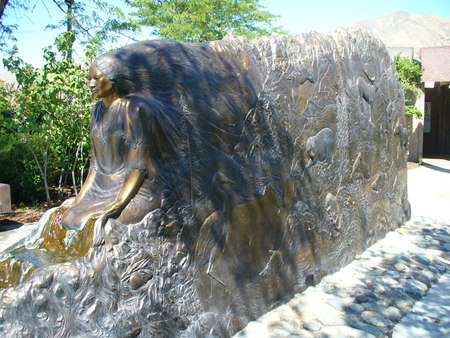
A U.S. Army Corps of Engineers Lewis and Clark Center at the confluence of the Snake and Clearwater has exhibits and an inspiring sculpture of a Native American earth figure. We thought the sculpture was of Sacagawea, but later learned differently. Regardless, it is quite stunning.
Ten miles east of Lewiston, we stopped at the main visitor center for Nez Perce National Historical Park, a wide-ranging National Park Service unit with multiple locations throughout the Nez Perce Nation. These friendly people saved the expedition from disaster when the starving and sick men of the Corps of Discovery following their descent from a long and tiring trip over the Bitterroot Mountains. The Nez Perce provided the men with food and offered to guide them west to the Columbia.
The visitor center offers books, exhibits, and an excellent video describing the history of the Nez Perce and their contact with traders, explorers, and homesteaders who moved through their land, most of which they eventually lost. Scheduled guided walks are offered at or near the visitor center.
Highway 12 follows the path of Lewis and Clark on both their outbound and return trips. The drive is quite scenic and provides access to several important Lewis and Clark sites. One site on their outbound journey is Canoe Camp where the Corps of Discovery spent ten days cutting trees and hollowing logs for five canoes that they would use going west. Trusting the Nez Perce, Lewis and Clark left their horses for the Indians to hold for their return the following year.
Another important site was Lolo Pass (elevation 5,233 ft.), which the men had to cross. The U.S. Forest Service operates a visitor center with books, films, and exhibits at the pass .
On the east side of the pass near the town of Lolo, Traveler's Rest was used as a campsite by Lewis and Clark on both their outbound and return journey. According to volunteers at the site, this is the only L&C campsite that has been documented by archeologists. Interestingly, one of the most important finds was residue of mercury that had been used in medication the men called “Thunderclaps.” These medicines had been given to the men by Dr. Benjamin Rush and were used for all types of illnesses. Taking them caused terrible diarrhea. The residue was found in an area of the campsite where the latrine would have been located. We wonder if the archeologists counted on this type of research when they were students.
Here is our Traveler's Rest video.
Traveler's Rest is where Lewis & Clark split on their return to St. Louis. Clark went south to hook up with the Yellowstone River, while Lewis went northeast toward Missoula and Great Falls. The two agreed to meet at the confluence of the Yellowstone and Missouri Rivers.
David and Kay Scott are regular contributors to the Traveler. Their book
The Complete Guide to the National Park Lodges was first published by the Globe Pequot Press in 1997 and is now in its sixth edition.
Story Categories:
A copy of National Parks Traveler's financial statements may be obtained by sending a stamped, self-addressed envelope to: National Parks Traveler, P.O. Box 980452, Park City, Utah 84098. National Parks Traveler was formed in the state of Utah for the purpose of informing and educating about national parks and protected areas.
Residents of the following states may obtain a copy of our financial and additional information as stated below:
- Florida: A COPY OF THE OFFICIAL REGISTRATION AND FINANCIAL INFORMATION FOR NATIONAL PARKS TRAVELER, (REGISTRATION NO. CH 51659), MAY BE OBTAINED FROM THE DIVISION OF CONSUMER SERVICES BY CALLING 800-435-7352 OR VISITING THEIR WEBSITE. REGISTRATION DOES NOT IMPLY ENDORSEMENT, APPROVAL, OR RECOMMENDATION BY THE STATE.
- Georgia: A full and fair description of the programs and financial statement summary of National Parks Traveler is available upon request at the office and phone number indicated above.
- Maryland: Documents and information submitted under the Maryland Solicitations Act are also available, for the cost of postage and copies, from the Secretary of State, State House, Annapolis, MD 21401 (410-974-5534).
- North Carolina: Financial information about this organization and a copy of its license are available from the State Solicitation Licensing Branch at 888-830-4989 or 919-807-2214. The license is not an endorsement by the State.
- Pennsylvania: The official registration and financial information of National Parks Traveler may be obtained from the Pennsylvania Department of State by calling 800-732-0999. Registration does not imply endorsement.
- Virginia: Financial statements are available from the Virginia Department of Agriculture and Consumer Services, 102 Governor Street, Richmond, Virginia 23219.
- Washington: National Parks Traveler is registered with Washington State’s Charities Program as required by law and additional information is available by calling 800-332-4483 or visiting www.sos.wa.gov/charities, or on file at Charities Division, Office of the Secretary of State, State of Washington, Olympia, WA 98504.
Comments
Love this. I visited much of this same route last year and found it completely fascinating. Particularly the Heart of the Monster.
It was wonderful to read about your time here in Clarkston, WA/Lewiston, ID at the North entrance to Hells Canyon! We sure hope that next time you can drop in to the Hells Canyon Visitor Bureau and say hello - we love to meet our visitors and find out how far everyone has traveled; plus, it lets us learn a bit about where they are from, as well. I especially like your video of the Lewis & Clark Discovery Center in Hells Gate State Park, that's a great space for kids to follow all the different animal prints they have pressed into the path out there.
We'll be sharing your post with our Facebook and Twitter communities and would love to have you join us there.
Facebook http://www.facebook.com/HellsCanyonVisitorBureau
Twitter http://www.twitter.com/HellsCanyon
Enjoy the rest of your road trip!
@HellsCanyon
It's hard to believe this route (US 12 in Idaho and Montana portions) is threatened...ExxonMobile is currently planning to obtain oversized permits for gigantic oil drums and equipment (some as long as 250 feet and up to 125 wide) that will stop all traffic as they travel from turnout to turnout...turning Scenic 12 into an industrial route and threatening the pristine Lochsa and Clearwater Rivers. Oh what we won't sacrifice for oil and corporate greed.