The Chiricahua Mountains stand shoulder to shoulder, rising over 6,000 feet in silent solidarity from the surrounding Sonoran and Chihuahuan deserts. Driving south from Willcox, Arizona, Highway 186 is sun-faded and snaked with cracks. Beyond barbwire fences, cattle graze on what grass they can find. A solitary pickup passes me, heading to town.
I am entering Chiricahua National Monument, named for the Chiricahua Mountains, homeland of the Chiricahua Apache people who lived here for generations. I am curious if this monument memorializes the people of this place, as well as preserving the distinct geology found here. Chiricahua, where the quiet mountains hold countless stories of violent upheaval.
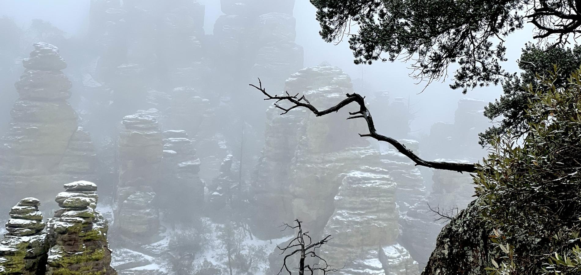
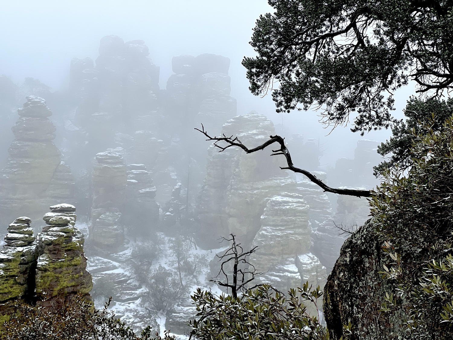
Driving down the monument’s main road, I glimpse green and shady Bonita Canyon Campground at the base of a redrock wall. This is my first view of the area’s stone columns and pinnacles. The Apache reportedly called this region, “The Land of Standing-Up Rocks.”
Twenty-seven million years ago, a series of volcanic eruptions rapidly covered 1,200 square miles with ash. The hot ash deposits (tuff) compressed into rock — “welded tuff” — and as it cooled, it contracted and cracked, allowing wind, water, and freeze/thaw cycles to erode these towering cylindrical shapes. The way the pinnacles have been carved by time, they resemble contemporary sculptures of human forms, suggesting ancient statues of the Chiricahua ancestors, formed of the very bedrock of their land, gathered together, watching.
Outside the visitor center doors, one glass-front display panel holds a weathered paper insert titled, “Homeland of the Chiricahua Apache.” It explains that the Chiricahua arrived here from farther north sometime between 1400-1500 CE, hunter-gatherers moving with the seasons between the warm plains and the cool mountains. “The band [of Chiricahua] living in this mountain range called themselves Chokonen, and sometimes referred to themselves as nde, simple meaning ‘the people.’”
Inside the crowded visitor center, after fighting my way through gift shop kitsch, I find several displays about the old Erickson ranch located on-site, and finally, way in the back, some hand-lettered, 1960s-esque wall exhibits again proclaiming, “This was the homeland of THE CHIRICAHUA APACHE.”
This was.
One panel notes that, after the Mexican-American War, “The Gadsden Purchase of 1853 settled the international boundary, giving the United States land needed for transportation routes across the Southwest, and new lands for settlement.” These routes cut through the heart of Apache territory. “For several years these new invaders passed unmolested. Then the Apache began to strike. They raided occasionally for loot but did not consider this a war.” Settlers, and the United States Government, ultimately did consider this war: The Apache Wars, from 1861-1886.
During the Apache Wars, Bonita Canyon was a Chiricahua Apache refugio, one of many such hiding places in their home mountains. What is the meaning of home, homeland, if not a refuge? The multigenerational Erickson/Riggs family, developing their Faraway Ranch here in 1888, felt such a connection to this land that they were instrumental in the monument’s creation. The Chiricahua Apache had also lived here in bands of multigenerational families, protected by their fiercest warriors: Massai, Cochise, Geronimo, and also Mangas Coloradas, Cochise’s sons Taza and Naiche, the warrior-woman Lozen, and many others. However, while the Ericksons have their own trail loop through their preserved homestead, a fenced family cemetery plot, an exhibit building in addition to visitor center displays, and multiple interpretive signs depicting their individual names, faces, and relationships, the Chiricahua have…Massai Point.
The namesakes of this place are disturbingly absent, their names erased. Yet, the trails somehow bring the Chiricahua leaders to mind, as if, according to Apache mysticism and worldview, the land itself still tells their stories.

The Spirits Of NDE, The People
I first hike to Inspiration Point, thinking of Cochise, the Great Chief, along the way. By many accounts, Cochise embodied Apache strength, wisdom, and dignity during a time of ever-increasing turmoil.
Today’s weather is changing, blustery and cool. The trail drops down into a narrow, mixed-forest canyon sheltered from the wind; it soon rises, steep in places, sometimes offering a soft white talc for footing, sometimes solid rock, the going becoming increasingly treacherous, slippery, and unpredictable.
The Apache Wars began in January 1861, when an 11-year-old boy named Felix Martinez Ward was kidnapped from his family’s homestead on Sonoita Creek during a cattle raid. The culprit (Beto, of the Aravaipa band) led his raiders into the mountains where Cochise’s Chokonen band lived. Cochise was requested to parley at Apache Pass with military officials, who believed him responsible. While offering to assist in locating the boy, Cochise’s entourage was suddenly taken hostage. Cochise cut the military tent with his knife and escaped. The young officer in charge refused to negotiate. Most of Cochise’s people were executed, including his favorite brother.
I follow a narrow streambed, still pooled from recent rains. Birds twitter in the scrub oaks, lizards dart within the rocks. I’d seen two turkeys earlier, white-tailed deer, and a coatimundi under the pines. It’s easy to imagine black bear or mountain lion roaming the side canyons.
At Inspiration Point, I take in the long view. The mountains seem built upon foundational walls of those primordial rock towers, ancestors rising, upholding everything. It’s easy to imagine this as someone’s unique, irreplaceable home.

I continue on to Big Balanced Rock. Lozen, the legendary female warrior, may have passed this way. The trail rises through a forest burn scar, exposing me to the darkening sky and the elements. Sister of Chief Victorio, Lozen was a shield warrior, a seer who could sense when danger approached and keep everyone safe. She went missing for a short time during the wars; she had come upon a lone Apache woman about to give birth and stayed with her, even as patrols passed by. Lozen rejoined her band to learn that, without her protection, Victorio had died in battle. I ponder the precariousness of Big Balanced Rock — 25 feet high, 22 feet in diameter, weighing a thousand tons, perched on an impossibly narrow base as if poised on one foot.
I come to the center of the circle, Heart of Rocks. An image of old Chief Mangas Coloradas arises. Steeped in tradition, uniter of tribes, for 15 years he tried to keep peace with the Americans. Until, on a goodwill errand, he was captured and bullwhipped by laughing, drunken miners. Until Cochise, his son-in-law, was betrayed at “Cut The Tent.” My heart beats faster. Mangas Coloradas, lured to the treaty talks he desired — then murdered in the night, his dead body later beheaded.
The wind begins to howl, moaning between the stones. The sky threatens icy rain. I retreat from the high trails as the weather turns perilous.
Echoes of History
The next morning, I arrive early at the trailhead for Echo Canyon. It’s foggy, cold, and snowy underfoot. I take my time, carefully picking my way down the trail, my footsteps muffled. I remember that Cochise taught his sons, Taza and younger brother Naiche, to cover their horses’ hooves with buckskin to quiet their steps.
After a long illness (possibly stomach cancer), Cochise died peacefully, laid to rest somewhere out here, hidden in the mountains. I look across the canyon through softly falling snow. The other side cannot be seen, hazy and obscured.
Taza, as the next chief, soon traveled with a delegation to Washington, D.C., to negotiate terms; unfortunately, he contracted pneumonia while there and also died, far from home.
I hear something and stop. A raven croaks; its hoarse voice echoes. Silence. It calls out again. I look for it but cannot see it, with the snow. The echoes fade.
Now only young Naiche remained, grieving, distrustful, suspecting witchcraft. He sought out the strong Chiricahua Apache man known for great spiritual power: Geronimo.
I have entered the shadowy caves and protected alcoves of the Grottoes. Nearing one, I feel icy wind rush up the sheer canyon wall on the other side and through this gap. The Grottoes are dangerous, yet enticing. Tortured evergreen trees grow among them, through them, like daggers.
Geronimo. The name given to the young shaman-turned-warrior Goyahkla after his mother, wife, and children were massacred by Mexican soldiers. It is said his terrified victims of retribution cried out in Spanish to Saint Jerome to heal and save them. Geronimo, the vicious killer who twisted his broken heart into never-ending vengeance.
Passing through the dark Grottoes, Geronimo’s stormy life leads me to follow Hailstone Trail. Here I walk a narrow trace across the steep flank of a mountain. Pelted now with dry graupel, I have no choice but to go on. I cannot possibly climb up the sheer slope, and below me the mountainside falls away precipitously. I cannot be done with this path until I reach the bitter end.
The Legacy Of Apache Pass
After my hike, I drive the dirt road to nearby Fort Bowie, established to protect Apache Pass and its vital spring during the Apache Wars. I take the footpath to the site. Here the Chiricahua were held as military prisoners before being shipped on trains to forts in Florida. They remained official prisoners of war for 27 years. Of the 1,200 Chiricahua Apache of Cochise’s days, only about 120 remained by the time they were finally relocated to Fort Sill Reservation in Oklahoma. Years later, some of the survivors joined the Mescalero Apache in New Mexico.
Nothing but stone foundations remain of the original Fort Bowie. The adobe walls of a later fort are slowly wearing away. At the nearby spring, green moss covers the rock where water still trickles out of the mountain, clear and cold.
Back at Chiricahua National Monument, I drive out to Massai Point, the end of the road, to watch the sunset. Massai was on the 1886 prisoner train to Florida with Lozen and 65-year-old Geronimo. But somewhere around Saint Louis, he jumped off into the night, making his way back home, raiding and surviving in the 87,000-acre Chiricahua Wilderness for 20 more years until his death.
Small, barely noticeable metal signs mark the monument’s trailheads — the pathways by which to enter and understand this place. None of the trails in their homeland are named for the Chiricahua people who once stood here.

Read more:
The Apache Wars: The Hunt for Geronimo, The Apache Kid, and the Captive Boy Who Started the Longest War in American History by Paul Andrew Hutton, distinguished professor of history, University of New Mexico (2016, Broadway Books).
Mescalero Apache Tribe: https://mescaleroapachetribe.com/our-culture
Barbara “Bo” Jensen is a writer and artist who likes to go off-grid, whether it's backpacking through national parks, trekking up the Continental Divide Trail, or following the Camino Norte across Spain. For over 20 years, social work has paid the bills, allowing them to meet and talk with people living homeless in the streets of America. You can find more of Bo's work on Out There podcast, Deep Wild Journal, Wanderlust, Journey, Months to Years, and www.wanderinglightning.com
Follow @wanderlightning [email protected]
Stories about:
Story Categories:
A copy of National Parks Traveler's financial statements may be obtained by sending a stamped, self-addressed envelope to: National Parks Traveler, P.O. Box 980452, Park City, Utah 84098. National Parks Traveler was formed in the state of Utah for the purpose of informing and educating about national parks and protected areas.
Residents of the following states may obtain a copy of our financial and additional information as stated below:
- Florida: A COPY OF THE OFFICIAL REGISTRATION AND FINANCIAL INFORMATION FOR NATIONAL PARKS TRAVELER, (REGISTRATION NO. CH 51659), MAY BE OBTAINED FROM THE DIVISION OF CONSUMER SERVICES BY CALLING 800-435-7352 OR VISITING THEIR WEBSITE. REGISTRATION DOES NOT IMPLY ENDORSEMENT, APPROVAL, OR RECOMMENDATION BY THE STATE.
- Georgia: A full and fair description of the programs and financial statement summary of National Parks Traveler is available upon request at the office and phone number indicated above.
- Maryland: Documents and information submitted under the Maryland Solicitations Act are also available, for the cost of postage and copies, from the Secretary of State, State House, Annapolis, MD 21401 (410-974-5534).
- North Carolina: Financial information about this organization and a copy of its license are available from the State Solicitation Licensing Branch at 888-830-4989 or 919-807-2214. The license is not an endorsement by the State.
- Pennsylvania: The official registration and financial information of National Parks Traveler may be obtained from the Pennsylvania Department of State by calling 800-732-0999. Registration does not imply endorsement.
- Virginia: Financial statements are available from the Virginia Department of Agriculture and Consumer Services, 102 Governor Street, Richmond, Virginia 23219.
- Washington: National Parks Traveler is registered with Washington State’s Charities Program as required by law and additional information is available by calling 800-332-4483 or visiting www.sos.wa.gov/charities, or on file at Charities Division, Office of the Secretary of State, State of Washington, Olympia, WA 98504.
Comments
Chiricahaua is a place I enjoyed too many years ago and have always wanted to return to visit again. Thanks for a great story about the place.
But I have a question that's not really related to this story. But it's one I've wondered about for a long time and perhaps someone reading this will be able to provide an answer. During that visit, almost 20 years ago (I think. Time flies.) I enjoyed an absolutely great program at the old ranch house given by a lady ranger. Later I had several other opportunities to tag along on some other of her presentations. But then, a year or so later, I heard the horrible news that she had been assaulted by someone as she cleaned a restroom while working in her other job there as a maintenance worker. The attacker stole her government truck and, I think, was finally apprehended several months later. Apparently, she had almost died from her injuries. I learned later that she was having a difficult time recovering. I have always wondered how that story ended. Was she ever able to return to the park and job she obviously loved?
So many years have passed that I can't even recall her name now. But I haven't forgotten how I felt when I heard what had happened to her.
Can anyone provide an update?
Lee, could this be the incident to which you refer?
https://www.nps.gov/orgs/1563/chir_assault_conviction.htm
Yes, that's it.
Is there any information on the victim? Did she recover? Was she able to return to work at the park? She had been VERY seriously injured in the attack and all these years since I heard of what happened, I've wondered about her.
Lee,
If you do a search on the victim, Karen Gonzales, you can learn that she attended the trial and sentencing. I'd name the perpetrator but he doesn't deserve it.
Maybe NPT could do a story on Ms. Gonzales, who suffered a great deal for no reason?
1960s-esque wall exhibits again proclaiming, “This was the homeland of THE CHIRICAHUA APACHE.”
Such a divisive and inaccurate exhibit has no place in the publicly owned visitor's center.
I understand that such "land acknowledgements" are all the rage today, but it's also accurate to proclaim that the monument belonged to the Spanish and Mexicans, and now the US. To acknowledge only one group who used and visited the area is divisive and promotes an ideological agenda. In any case, the Chirachua Apache were nomadic, and thus never really inhabited a "homeland"--they were NOMADIC!
Are the actual, historical tragedies of the Chirachua Apache not enough? Why exaggerate and make a false claim about a "homeland"?
Otherwise, this is a very thorough report of what is availabe at the monument. Thanks, NPT.
Thank you. I had done some searches, but without the name of Ms. Gonzalez, I came up with zero. I'll try again with her name.
My wife and I made what we thought would be detour to this place in 2021 during the height of the covid epidemic. Our detour turned into a multi day stay. The author captures a bit of what this place is, in a short article, but its so much more. First off, it's much more specacular than the author's description and pictures capture. I've been to probably 300 state and national forests, preserves, parks, monuments, historical areas and reserves. This place and the area around it put most of them to shame for scenery alone. It's got features and and scenery like Badkands, Bryce, Death Valley, Canyanlands.... It deserves to be a full national park. The place was central to the development of the US and a fuller description of what happened to the Apaches needs to be much more fully discussed there. The park's (and I use that word intentionally) facilitie and staff is woefully inadequate. I wish there was a movement to make this place (and much of the area around it) a real National Park. It deserves it.