
Editor's note: Once the focus of widespread environmental concern over water quality, the Chesapeake Bay is also now on the front lines of climate change. The bay and the places within the watershed that are managed by the National Park Service are at risk from the effects of climate change, including sea-level rise, and the damage wrought by increasingly severe storms. These threats exacerbate and accelerate longstanding concerns about environmental pollutants and runoff in the region and landed the Park Service properties within the watershed on the National Parks Traveler's 3rd Annual Threatened and Endangered Parks list.
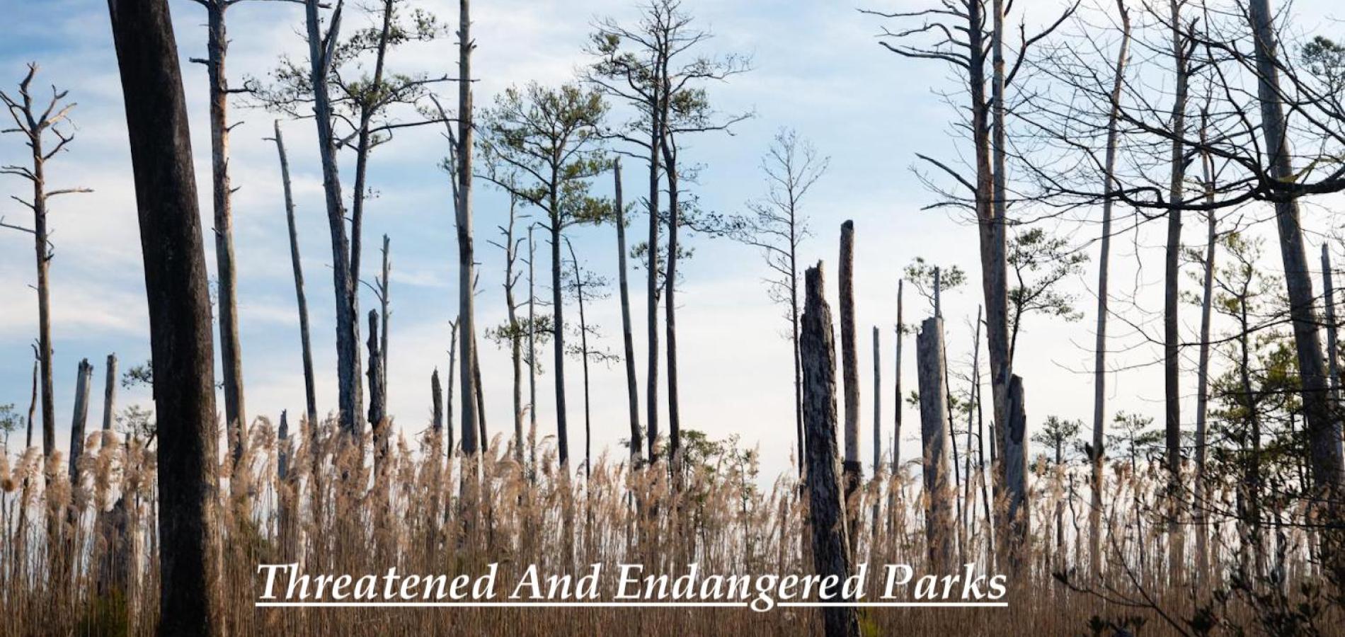
Along the Chesapeake Bay on Maryland’s Eastern Shore, Blackwater National Wildlife Refuge is a marshy wilderness of fields and open water, dotted with stands of evergreen and deciduous trees, where herons, egrets, and countless other birds perch regally along the brackish wetlands. Here too, however, are eerie collections of barren, ashen, leafless stumps—the refuge’s “ghost forests,” which are irrefutable evidence of climate change.
These ghost forests occur when rising sea levels push too much saltwater inland, inundating trees that aren’t meant to grow in such watery conditions. An estimated 5,000 acres of the wildlife refuge have been converted from tidal marshland to open water since the refuge was created in 1933, and the U.S. Fish and Wildlife Service estimates that the sea level around Blackwater could rise around three feet by 2100. At that rate, two-thirds of the area’s tidal marshes could be under water in as short as three decades.
“The Chesapeake Bay is one of the most threatened ecosystems in the United States when it comes to sea level rise,” says Reed Perry, manager of external affairs for the nonprofit Chesapeake Conservancy. “There is already erosion, but development has accelerated the process of erosion, and sea level rise is threatening coastal communities and marshland places like Blackwater National Wildlife Refuge.”
Blackwater is just one iconic landscape in the Chesapeake Bay watershed that is at risk from the effects of climate change, which includes devastation wrought by increasingly severe storms and altered weather patterns and seasonal cycles, in addition to rising water levels. Coastal communities and landscapes throughout the bay are experiencing increasing flooding due to sea level rise, which is compounded by the fact that the mid-Atlantic region is also sinking in a natural process known as subsidence. These threats exacerbate and accelerate longstanding concerns about environmental pollutants and runoff in the region.
At risk are numerous natural, cultural, and historic areas, including places managed by the National Park Service. But several initiatives and programs, including the proposed Chesapeake National Recreation Area, offer reasons for hope.

Threatened Sites
Over the last four decades, the primary concern about the Chesapeake Bay was its water quality. The bay is the largest estuary in North America, about 200 miles long and 30 miles across at its widest point, and boasting nearly 12,000 miles of shoreline when you count both the bay and its numerous tributaries. It’s home to an estimated 282 million blue crabs—the “beautiful swimmers,” as author William Warner famously wrote, that serve as the bay’s most iconic symbol and very real source of livelihood—and provides habitat and food for hundreds of other animal species.
Climate change is affecting many of the watershed’s low-lying cultural and historic sites, including such areas managed by the National Park Service as the Captain John Smith Chesapeake National Historic Trail (a water trail for paddlers), the Werowocomoco village site, Fort Monroe National Monument, and Harriet Tubman Underground Railroad National Historical Park.
As significant as the waterway is, its watershed is equally so. Home to more than 18 million people, the Chesapeake Bay watershed encompasses more than 64,000 square miles and crosses parts of six states—Delaware, Maryland, New York, Pennsylvania, Virginia, and West Virginia—and all of Washington, D.C. Iconic historic sites in the watershed, including those in D.C., Richmond, and Baltimore, are also at risk from sea level rise.
The Chesapeake Bay Program, the decades-old partnership that oversees Chesapeake restoration work, estimates that 100,000 streams, creeks, and rivers run through the watershed. With a land-to-water ratio of 14:1—the largest ratio of any coastal water body in the world, according to the Chesapeake Bay Program—land-based activities have an outsized impact on the region’s waterways. So the story of the Chesapeake is not just about water, but about forests, cities, farms, factories, and suburbs, too.
The Chesapeake’s first “dead zone,” a hypoxic area created by excessive pollutants such as nitrogen and phosphorus, was discovered in the 1930s, but began to gain widespread attention in the 1970s and ‘80s. For years, the Chesapeake Bay has been included on the Clean Water Act’s "impaired waters" list because of nutrient pollution. Federal and state entities in the region have now committed to reducing nitrogen, phosphorus, and sediment pollution to get the Bay and its tributaries off the list by 2025.
In its 2020 State of the Bay report, the Chesapeake Bay Foundation gave the bay a “D+” rating, based on 13 health indicators, including nitrogen and phosphorus, water quality, chemicals, tree canopy, underwater grasses, striped bass (also known as rockfish), oysters, and crabs. Among these, four indicators declined over 2018 levels—forested buffers, underwater grasses, rockfish, and shad. Although the report showed some positive trends—improving pollutant scores, a shrinking dead zone, and better oyster numbers—striped bass proved to be well below sustainable levels, due to a combination of overfishing, lower prey numbers, low oxygen levels, and potential impacts of warming waters on spawning ability, and young fish health.

Mitigating Efforts
What the Chesapeake has going for it, however, are longstanding partnerships and programs that are dedicated to its health and restoration, including the Chesapeake Gateways and Water Trails Network, which connects and elevates national parks and other historic, cultural, and recreational sites throughout the watershed, including Blackwater National Wildlife Refuge and the Captain John Smith water trail.
“Chesapeake Gateways is a 20-year-long program that has really been a source of partnerships and innovation in the Park Service,” Wendy O’Sullivan, superintendent of the NPS Chesapeake Office, said in a September interview about the new Chesapeake Storytellers program. “We are able to partner with federal, state, and nonprofits, but we also have authority in our legislation that uses the phrase ‘and the private sector,’ and that to me is so exciting and such an opportunity to meet the intent of what Chesapeake Gateways is, which is to connect visitors with the authentic people and stories of the Chesapeake.”
Also critical is to take sustainability and resilience into account with any new park development. At the Harriet Tubman Underground Railroad National Historical Park and State Park, a cooperative venture between the NPS and the state of Maryland, a visitor center built in 2017 acts as both an interpretive center and an example of sustainable design.
Tubman was born enslaved in the area in 1822 and knew the marshlands well, returning to the area several times as she helped enslaved people escape.
The new visitor center, designed by GWWO Architects and with landscape architecture from Mahan Rykiel Associates, orients visitors from south to north as they move through the space, symbolizing the movement from slavery to freedom. The building has earned a LEED Silver designation for sustainable design elements, which include vegetated roofs, on-site rainwater containment for irrigation, bio-retention ponds (vegetated areas that capture and store stormwater runoff), and low-flow fixtures.
“There’s certainly a way to achieve a balance where conservation and development can work hand in hand as long as we do it in a way that’s sustainable,” Perry says.
This work includes land-based conservation efforts such as planting riparian buffers and helping large agricultural landowners to institute conservation practices, as well as community outreach and cleanup efforts, all of which are initiatives embraced by the nonprofit Alliance for the Chesapeake Bay, among others. “When I think about the greatest threats facing the bay, [we need] the engagement of the 18 million people who live here and creating awareness that their backyard is the Chesapeake Bay,” says Alliance CEO Kate Fritz. “We all have the ability to make small changes to protect the waterway.”
The Chesapeake Conservancy released a report in 2021 that illustrated that water quality improvement efforts in Virginia’s portion of the Chesapeake Bay watershed also removed carbon from the atmosphere, an essential climate-change mitigation. In 2019, an estimated 459,639 tons of carbon dioxide equivalent were removed from the atmosphere by agricultural conservation practices, which equates to the annual carbon sequestration of 510,000 acres of forestland or approximately 0.4 percent of Virginia’s energy-related CO2 emissions.
Susan Minnemeyer, the Chesapeake Conservancy’s vice president for technology, says that the organization is increasingly using high-resolution mapping to help identify landscape changes and high priority areas for conservation, either through private conservation easements or other means. “Most land trusts, their key actors are working with land donors, so they’re often very opportunistic,” she says. “There’s now more interest in making it more strategic, approaching landowners in terms of easements and land legacy acts, figuring out how to help land trusts identify the best places to be protected.”

She adds that the conservancy is working closely with the U.S. Department of Defense on its REPI (Readiness and Environmental Integration Protection) program, which has targeted the Middle Chesapeake Sentinal Landscape region, including parks, refuges, military installations and other areas in need of mitigation from the effects of climate change.

A National Recreation Area
Clearly, this is not a landscape where one agency or entity reigns supreme over others, and that’s important to keep in mind as a proposal to create a Chesapeake National Recreation Area moves forward. The idea of creating an encompassing national park for the bay has been around for decades, but has recently gained broad support on the federal, state, and local levels. This is in large measure because it would funnel more federal dollars into the region and result in more protected watershed land, while respecting the bay as a rich mosaic of sites and as a working waterway upon which thousands of watermen and women depend, supporters say.
In early 2021, U.S. Senator Chris Van Hollen and Congressman John Sarbanes, both Maryland Democrats, led a group of lawmakers and more than 30 regional organizations in forming a working group to explore the designation of the CNRA. “We’re hoping to see draft legislation early in the new year,” says Reed Perry. “That will be circulated for public comment among all the important stakeholders, and Sen. Van Hollen will take that feedback and then introduce a bill. There’s already great bicameral, bipartisan support for a national recreation area.”
“My hope is that if the CNRA is created, it’s going to bring more attention to these gemstones of the Chesapeake, so we’re getting more people out and participating and touching the water or the trees or whatever part of the watershed they’re participating in,” Fritz says. “I’m hoping we’re going to have more access, which is a huge issue. Seventy-five percent of the shoreline is in private ownership, so it makes it even more important for the NPS to make sure there is equitable access for all communities. Engaging a more diverse constituency in a more inclusive way and giving more equity to access is paramount to moving this work forward together.”
Stories about:
Story Categories:
A copy of National Parks Traveler's financial statements may be obtained by sending a stamped, self-addressed envelope to: National Parks Traveler, P.O. Box 980452, Park City, Utah 84098. National Parks Traveler was formed in the state of Utah for the purpose of informing and educating about national parks and protected areas.
Residents of the following states may obtain a copy of our financial and additional information as stated below:
- Florida: A COPY OF THE OFFICIAL REGISTRATION AND FINANCIAL INFORMATION FOR NATIONAL PARKS TRAVELER, (REGISTRATION NO. CH 51659), MAY BE OBTAINED FROM THE DIVISION OF CONSUMER SERVICES BY CALLING 800-435-7352 OR VISITING THEIR WEBSITE. REGISTRATION DOES NOT IMPLY ENDORSEMENT, APPROVAL, OR RECOMMENDATION BY THE STATE.
- Georgia: A full and fair description of the programs and financial statement summary of National Parks Traveler is available upon request at the office and phone number indicated above.
- Maryland: Documents and information submitted under the Maryland Solicitations Act are also available, for the cost of postage and copies, from the Secretary of State, State House, Annapolis, MD 21401 (410-974-5534).
- North Carolina: Financial information about this organization and a copy of its license are available from the State Solicitation Licensing Branch at 888-830-4989 or 919-807-2214. The license is not an endorsement by the State.
- Pennsylvania: The official registration and financial information of National Parks Traveler may be obtained from the Pennsylvania Department of State by calling 800-732-0999. Registration does not imply endorsement.
- Virginia: Financial statements are available from the Virginia Department of Agriculture and Consumer Services, 102 Governor Street, Richmond, Virginia 23219.
- Washington: National Parks Traveler is registered with Washington State’s Charities Program as required by law and additional information is available by calling 800-332-4483 or visiting www.sos.wa.gov/charities, or on file at Charities Division, Office of the Secretary of State, State of Washington, Olympia, WA 98504.
Comments
The migration from Holland Island illustrates the human toll of ignoring this situation we're now facing. Iimages of the last home tha stood there are frequently used to illustrate the problems. www.HollandIslandBook.com/