
The National Park Service and its stakeholders are working to transform the St. Anthony Lock and Dam into a user friendly recreation area that will provide visitors with more information on this historic structure and more space to relax / Friends of the Lock and Dam
The citizens of Minneapolis are coming together to give new life to the riverfront along the Mighty Mississippi. Nearby, old mills are now museums, warehouses are co-op apartments, light transit abounds, and pedestrians walk new trails. This bustling metropolis is looking towards the river, knowing that in order to preserve historic structures in historic areas that have outlived their usefulness, you have to give them new life with a new purpose. And that’s a boon for residents and tourists alike.
As part of that approach, planning is now underway to repurpose the historic Upper St. Anthony Falls Lock and Dam.
In 1937 Congress approved the Upper Minneapolis Harbor Development Project, which included the Upper St. Anthony Falls Lock and Dam, completed in 1963. But in 2015, partly in response to the threat of invasive species (primarily Asian carp), and partly because the lock could only take two barges at a time, the upper lock was closed for business. So, for the past year the public, government, and other stakeholders have been devising a new plan for the site. It’s a unique structure in a unique setting, steeped in history. And it looks like it’s well on the way to happening.
The Mississippi River bisects America, from its headwaters in the dense northern forests and straight through the heartland. It drains more than one million square miles of the United States, from Montana to Pennsylvania, from Nashville to Fargo. The cities of New Orleans, Memphis, and St. Louis all grew along its banks, relying on the powerful waters for transportation, agriculture, and industry. But, there is no place with a history more linked to the mighty river than the cities of Minneapolis and St. Paul, and it’s all because of the mighty St. Anthony Falls that divides them.
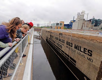
The St. Anthony Falls and Lock aimed to neutralize the only major drop along the Mississippi River/NPCA
St. Anthony Falls is the only major cataract along the Mississippi River’s 2,320-mile journey, pouring over a limestone shelf and dropping 50 feet. In fact, this drop accounts for 10 percent of the total height change of the Mississippi River between the Twin Cities and St. Louis. The river attracted pioneers, homesteaders and settlers, but it was the force of the falls that powered lumber mills, textile factories, and agricultural machinery, and later its electricity ran machinery and lighted the cities.
While wheat was ground, cloth was made, and boards were sawn along its banks, canoes, paddle wheelers, and barges carried people and cargo to market. While the falls themselves were a formidable obstacle to passage, they were overcome by construction of giant locks, giving access to the upper reaches of the river.
National Park Service rangers still take visitors on tours of the lock and dam, as it is part of the Mississippi National River and Recreation Area. But now there is a grand vision to transform the site, along with the historic stone arch bridge just downstream, into a major recreation area.
John Anfinson, superintendent for the recreation area, sees the potential.
“One of the things, as an advocate, is that people in the Twin Cities don’t know that this is a national park, and a part of the (national) park system. It’s a highly visible location, which raises the visibility of the Park Service. It’s great for tourism,” he says.
Folded into the grand plans, the James J. Hill Stone Arch Bridge, completed in 1883 for the railroad, already sees thousands of pedestrians as part of the St. Anthony Falls Heritage Trail. Though it needs about $13 million in repairs, the bridge is becoming an ever more popular spot for bikes, kids and walkers, and increasing.
“Our visitation has grown from 112,000 in 2015, to 221,000 in 2016, and over 400,000 visitors in 2017,” says Anfinson. “If St. Anthony’s becomes a world-class visitor center, then over 2 million people will cross the stone arch bridge.”
Every Father’s Day weekend, the Stone Arch Festival entertains over 10,000 people a day with music, food, and entertainment. And that sort of thing could grow.
There are lots of different stakeholders working together. Since 2011 more than 20 statewide groups and national organizations have come together to create a plan for the future. The City of Minneapolis and the Minneapolis Park and Recreation Board passed supporting resolutions last summer. A study by the U.S. Army Corps of Engineers on the project is expected to be finished by late 2019. Last year alone the Friends of the Lock and Dam (thefalls.org) raised $5 million, and last February Minnesota state Sens. Jeff Hayden, Bobby Champion, and Kari Dziedzic introduced a bill to appropriate funds for the redevelopment.
The idea is to turn the area into a hub of recreation for outdoor activities like biking, fishing, paddling, water taxis, and walking. The plan also includes a visitor center where guests cannot only get something to eat, but learn about the river, the region, and the National Park Service.
From her role as associate director of the Midwest region for the National Parks Conservation Association, Christine Goepfert says, “There are many stories to tell in this stretch of the river and the demand to get on the river will only increase.”
Friends of the Lock and Dam’s Kjersti Monson says, “This is an incredible iconic feature. We’re kind of standing here at the place where Minneapolis was born.”

An artist’s representation of the lock and dam / Friends of the Lock and Dam
A number of options are on the table for that evolution. One, though unlikely, is to remove the lock and dam itself.
“If you take out the lock at high water it will be big rapids,” says Superintendent Anfinson. “At low water you could float on an inner tube through the 8.5-mile gorge. In 1858 steamboats came and went from St. Paul over 1,000 times.”
One believer in the lock and dam’s future is Paul Reyelts, the former chief officer at the Valspar Corporation. His $400,000 contribution primed the pump for the friends’ group.
The falls are in close proximity to downtown Minneapolis and other facilities, including the Guthrie Theatre, Mill City Museum, and the waterworks park. Reyelts and the friends group see the renaissance as a way to revitalize the waterfront and give energy to this essential waterway that was the birthplace of these magnificent cities.
Preliminary plans show a greenspace along the river, walkways and paths, public spaces and historic signage. And it’s not just for locals.
“Over 40 percent of our visitors at the national park’s visitor center are from out of state,” says the superintendent.
As the makeover continues, all those visitors might be able to get a better sense, and view, of the power and majesty of the mother of all waters—the Mississippi River—from the green space at the base of the lock.
“To stand there where the water jumps up, there’s no place on the river where you can experience so much power next to the falls,” says Anfinson.
And while there’s no set date for completion of the project, it seems well on the way to becoming a reality.
Stories about:
Story Categories:
A copy of National Parks Traveler's financial statements may be obtained by sending a stamped, self-addressed envelope to: National Parks Traveler, P.O. Box 980452, Park City, Utah 84098. National Parks Traveler was formed in the state of Utah for the purpose of informing and educating about national parks and protected areas.
Residents of the following states may obtain a copy of our financial and additional information as stated below:
- Florida: A COPY OF THE OFFICIAL REGISTRATION AND FINANCIAL INFORMATION FOR NATIONAL PARKS TRAVELER, (REGISTRATION NO. CH 51659), MAY BE OBTAINED FROM THE DIVISION OF CONSUMER SERVICES BY CALLING 800-435-7352 OR VISITING THEIR WEBSITE. REGISTRATION DOES NOT IMPLY ENDORSEMENT, APPROVAL, OR RECOMMENDATION BY THE STATE.
- Georgia: A full and fair description of the programs and financial statement summary of National Parks Traveler is available upon request at the office and phone number indicated above.
- Maryland: Documents and information submitted under the Maryland Solicitations Act are also available, for the cost of postage and copies, from the Secretary of State, State House, Annapolis, MD 21401 (410-974-5534).
- North Carolina: Financial information about this organization and a copy of its license are available from the State Solicitation Licensing Branch at 888-830-4989 or 919-807-2214. The license is not an endorsement by the State.
- Pennsylvania: The official registration and financial information of National Parks Traveler may be obtained from the Pennsylvania Department of State by calling 800-732-0999. Registration does not imply endorsement.
- Virginia: Financial statements are available from the Virginia Department of Agriculture and Consumer Services, 102 Governor Street, Richmond, Virginia 23219.
- Washington: National Parks Traveler is registered with Washington State’s Charities Program as required by law and additional information is available by calling 800-332-4483 or visiting www.sos.wa.gov/charities, or on file at Charities Division, Office of the Secretary of State, State of Washington, Olympia, WA 98504.
