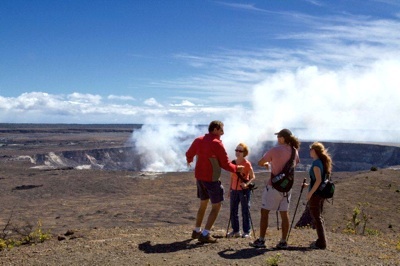
A popular hike at Hawaii Volcanoes National Park leads you to the Halema'Uma'u Crater on one side of the enormous Kilauea Caldera. Hawaii Forest & Trail photo.
When travel literature enthuses about the “ever-changing panorama” of this place or that, it usually means that when you visit, the trees might be leafed out, radiant with fall colors or have bare branches, or that snow blankets the hillsides, or some such. There is change, to be sure, but it is mostly ephemeral and seasonal.
Not at Hawaii Volcanoes National Park, where major changes happen right before our eyes. Hawaii’s Big Island is shaped roughly – very roughly – like a diamond, with the park occupying 330,000 acres on the southeast side. The park’s 13,677-foot high point is the rounded hulk of Mauna Loa, which erupted most recently in 1984.
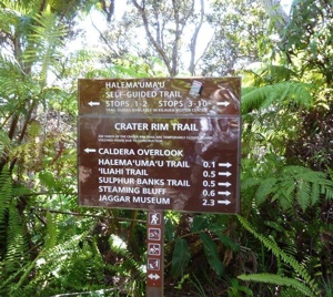
Several trails lead you around the crater. Photo by Claire Walter.
Neighboring Kīlauea, which volcanologists know to be a separate volcano, began its current eruption cycle Jan. 3, 1983, when a massive new vent called on the Pu’u O’o cone on the volcano’s Eastern Rift Zone started belching vapors, ash and particulate matter high into the sky.
Call it eruption overlap.
Kīlauea has been active ever since. Braided rivers of glowing lava have flowed down slopes of hard, black lava from previous eruptions. Hollow tubes have provided direct conduits from fissures and vents to the sea, setting off great steam clouds as the molten rock sizzles into the sea. Some 600 acres of land have been added to the park and to the Big Island itself.

All the volcanic activity has created some interesting trails at the park. Photo courtesy of Hawaii Forest and Trail.
For a time, lava flows ceased as Pu’u O’o released gases and material. Fiery lava lakes developed deep within the crater, and on Aug. 3, the bottom seemed to fall out of the lake, which dropped precipitously, and following rapid-fire volcanic activity, lava began flowing again.
The volcano’s “performance” that changes is captivating by day and totally stunning after dark.
At this writing, lava fountains are erupting from fissures and cracks. Long after the visitor center and gift shop close for the night, scores of visitors remain at viewing areas perched at nearly 4,000 feet along the crater rim. They line up to peer through binoculars or scopes, or capture nature’s light show with long-lensed cameras.
The park has two scenic drives, Crater Rim Drive, an 11-miler around Kīlauea’s summit, and 18-mile down-and-back Chain of Craters Road that descends 3,700 feet to the sea. It crosses lava flows and dead-ends at a lava flow.
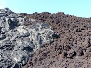
Two types of surface lava -- ropey pahoehoe and smooth, can be found along the Chain of Craters Road. Claire Walter photo.
A walking route across the lava is opened and closed, depending on current activity. Following the latest eruption, a good chunk of Crater Rim Drive and a couple of hiking trails were closed, and when they might reopen is unknown.
To Rob Pacheco, who founded Hawaii Forest & Trail in 1993 to offer naturalist tours around the Big Island, the road closures and other eruption interruptions are manifestations of the earth’s power to remake itself. He knows the dates and magnitude of each eruption and how it changed the landscape. He knows where to find mysterious, mystical petroglyphs carved by the ancients on old lava fields and the first appearance of plantlife on new ones, as well as where wildlife can be found.
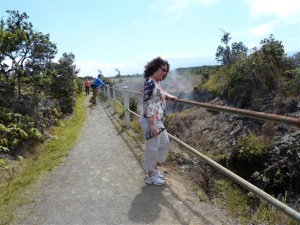
Steam vents can be found beside the Crater Rim Trail. Claire Walter photo.
He and his guide staff enjoy sharing Hawaii Volcano National Park’s roster of superlatives:
* Mauna Loa is the most massive volcano on the planet.
* Eruptions in 1959 produced seven fountain “events” that projected glowing lava as high as 1,900 feet, the most known, and emitted up to 600 tons of gases every day for the duration.
* The park’s lavascapes are desert dry, yet it also boasts a verdant rainforest. Its rate of endemic plant and animal species is one of the highest in the world.
Guides also recount the ancient Hawaiian belief in Pele, the goddess of fire, lightning, dance and volcanoes who is credited with or blamed for both historic and natural events, and who resides in Kilauea’s Halemaʻumaʻu crater.
To help the Park Service protect native plants from invasive species, Hawaii Forest & Trail vehicles stop at an accessible spot where guests help pull aggressive kahili ginger rhizomes. They only stop for 15 minutes or so, but a dozen or more people can remove a lot of alien plants in a very short time.
When left unchecked this perennial from Tibet can grow up to six or seven feet in the Hawaiian forest and muscle out native plants.
Other park attractions include the walk-through Thurston Lava Tube, 150 miles of hiking trails from mild to wild, and the fascinating Jaggar Museum whose displays about volcanology include working seismographs and other equipment used by the scientists to study volcanoes and volcanic activity.
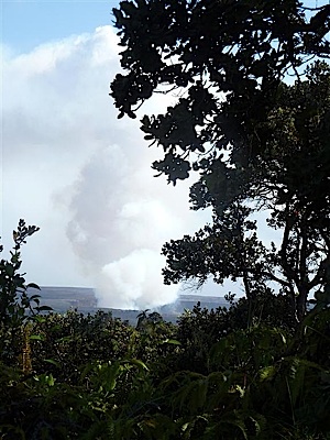
Steam from the Pu'u O'o Crater is easily seen. Claire Walter photo.
The museum's overlook has been the best place to look down into Halema`uma`u crater where an eruption that began March 11, 2008, has been creating a crater within a crater, with Pu’u O’o activity in the distance.
And elsewhere in this remarkable park, the hot lava is flowing and glowing.
At least for now.
Story Categories:
A copy of National Parks Traveler's financial statements may be obtained by sending a stamped, self-addressed envelope to: National Parks Traveler, P.O. Box 980452, Park City, Utah 84098. National Parks Traveler was formed in the state of Utah for the purpose of informing and educating about national parks and protected areas.
Residents of the following states may obtain a copy of our financial and additional information as stated below:
- Florida: A COPY OF THE OFFICIAL REGISTRATION AND FINANCIAL INFORMATION FOR NATIONAL PARKS TRAVELER, (REGISTRATION NO. CH 51659), MAY BE OBTAINED FROM THE DIVISION OF CONSUMER SERVICES BY CALLING 800-435-7352 OR VISITING THEIR WEBSITE. REGISTRATION DOES NOT IMPLY ENDORSEMENT, APPROVAL, OR RECOMMENDATION BY THE STATE.
- Georgia: A full and fair description of the programs and financial statement summary of National Parks Traveler is available upon request at the office and phone number indicated above.
- Maryland: Documents and information submitted under the Maryland Solicitations Act are also available, for the cost of postage and copies, from the Secretary of State, State House, Annapolis, MD 21401 (410-974-5534).
- North Carolina: Financial information about this organization and a copy of its license are available from the State Solicitation Licensing Branch at 888-830-4989 or 919-807-2214. The license is not an endorsement by the State.
- Pennsylvania: The official registration and financial information of National Parks Traveler may be obtained from the Pennsylvania Department of State by calling 800-732-0999. Registration does not imply endorsement.
- Virginia: Financial statements are available from the Virginia Department of Agriculture and Consumer Services, 102 Governor Street, Richmond, Virginia 23219.
- Washington: National Parks Traveler is registered with Washington State’s Charities Program as required by law and additional information is available by calling 800-332-4483 or visiting www.sos.wa.gov/charities, or on file at Charities Division, Office of the Secretary of State, State of Washington, Olympia, WA 98504.
