Lewis and Clark Cavern. Undated (probably late 1920s) National Geographic Society archival photo by D.B. Church.
Proclaimed in 1908, Montana's Lewis and Clark Cavern National Monument never could get the monetary support needed to develop it is a viable unit of the National Park System. Congress abolished it in 1937.
Near Whitehall in western Montana there is a place where karst processes slowly dissolved some of the rock in the Mississippian-age Madison Limestone, creating a cavern that was first seen by non-natives in the early 1880s. The cave was subsequently named for explorers Meriwether Lewis and William Clark because the site overlooks the trail that the Corps of Discovery followed along the Jefferson River in 1805. Lewis and Clark actually never laid eyes on the cave, whose entrance sits 1,400 feet above the river.
Two hunters, Tom Williams and Bert Pannell, discovered the cave in 1892 and explored it with the help of some friends in 1898. In 1901, they and local miner Dan Morrison developed it for public use under the name "Limespur Cave." A fairly extensive ladder and stair system -- something on the order of 2,000 stairs/steps -- was constructed before the Northern Pacific Railway successfully laid claim to the land in court.
The Northern Pacific Railway offered the land to the federal government as a preserve, and on May 11, 1908, President Theodore Roosevelt proclaimed Lewis and Clark Cavern National Monument as America's 15th national monument. The land was still unsurveyed at that time, and three more years elapsed before the compact site (just 160 acres) was fully surveyed and declared. The declaration was finalized when President William Howard Taft signed a second proclamation on May, 16, 1911.
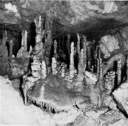
A 1930 National Park Service publication enitled Glimpses of Our National Monuments includes this description of the monument:
The general appearance of the cave is that of a fissure in a steeply inclined bed of limestone. Its maximum measurements are 600 feet long and 400 feet deep, but its numerous passages and rooms make it appear miles in extent rather than hundreds of feet.
The walls of the cave are decorated with marvelous stalactites and the floor with corresponding stalagmites. Huge fragments of limestone, some as big as the ordinary house room, have fallen from the roof in many places. In places the stalactites are found in terraces; a fringe of delicately carved forms, swelling at different levels, gives the appearance of cascades. Many of the stalagmite columns, encircled by horizontal rings with pendent stalactites, are superbly beautiful. All manner of curious drip formations add to the wild beauty of the cave. ... Eight or ten chambers have been explored, the largest of these being 105 by 135 feet and 100 feet high.
As public caves go, this one was pretty challenging. Getting there was the first hurdle.
[The cave] is situated at a point about 5 miles from the popular transcontinental highway known as the Yellowstone Trail, near Cardwell and about 14 miles from Whitehall on the Northern Pacific Railroad. After leaving the Yellowstone Trail a poor road ascends part way up the mountain. A trail then leads to the cave entrance requiring a climb of about 45 minutes.
The few visitors who made that arduous journey were not coddled once they entered the cave, either: "From the main entrance a stairway leads irregularly down about 175 feet and then small tortuous passages, opening into the chambers, and ladders, carry the venturesome visitor into the depths."
No lighting system existed, nor were there rangers on hand to serve as guides. The cave was, in fact unprotected as well as dangerous. At the time this 1930 report was rendered, the cave had been officially closed for years because of vandalism and safety concerns.
The cave was made safer and more accessible in the 1930s, with much of the work being done by about 200 Civilian Conservation Corps workers between 1935 and 1941. Nevertheless a chronic lack of funds made it impossible to properly develop the cave, provide staffing, and open it for public use.
Many Montana residents, including some influential ones, grew unhappy with federal neglect of the national monument, which was not drawing tourists -- and their money -- to the area. Finally, in 1935 Montana governor Frank Cooney formally requested that the federal government turn the property over to Montana for development as a state park.
On August 24, 1937, Congress abolished Lewis and Clark Cavern National Monument and transferred the property to the state of Montana. It was subsequently improved for public use (with the first lighting installed in 1940) and dedicated as Montana's first state park in 1941.
Postscript: Today, Montana's Lewis and Clark Caverns State Park encompasses 3,000 acres, is open year-round, and features improvements such as a visitor center, picnic facilities,10 miles of hiking trails, and 40 campsites, Guided tours of the caverns are offered from May 1 to September 30. It's quite chilly in the cave (about 50 degrees), and the two-hour tours require you to walk two miles, navigate 600 steps, and do a good bit of stooping and bending.
Story Categories:
A copy of National Parks Traveler's financial statements may be obtained by sending a stamped, self-addressed envelope to: National Parks Traveler, P.O. Box 980452, Park City, Utah 84098. National Parks Traveler was formed in the state of Utah for the purpose of informing and educating about national parks and protected areas.
Residents of the following states may obtain a copy of our financial and additional information as stated below:
- Florida: A COPY OF THE OFFICIAL REGISTRATION AND FINANCIAL INFORMATION FOR NATIONAL PARKS TRAVELER, (REGISTRATION NO. CH 51659), MAY BE OBTAINED FROM THE DIVISION OF CONSUMER SERVICES BY CALLING 800-435-7352 OR VISITING THEIR WEBSITE. REGISTRATION DOES NOT IMPLY ENDORSEMENT, APPROVAL, OR RECOMMENDATION BY THE STATE.
- Georgia: A full and fair description of the programs and financial statement summary of National Parks Traveler is available upon request at the office and phone number indicated above.
- Maryland: Documents and information submitted under the Maryland Solicitations Act are also available, for the cost of postage and copies, from the Secretary of State, State House, Annapolis, MD 21401 (410-974-5534).
- North Carolina: Financial information about this organization and a copy of its license are available from the State Solicitation Licensing Branch at 888-830-4989 or 919-807-2214. The license is not an endorsement by the State.
- Pennsylvania: The official registration and financial information of National Parks Traveler may be obtained from the Pennsylvania Department of State by calling 800-732-0999. Registration does not imply endorsement.
- Virginia: Financial statements are available from the Virginia Department of Agriculture and Consumer Services, 102 Governor Street, Richmond, Virginia 23219.
- Washington: National Parks Traveler is registered with Washington State’s Charities Program as required by law and additional information is available by calling 800-332-4483 or visiting www.sos.wa.gov/charities, or on file at Charities Division, Office of the Secretary of State, State of Washington, Olympia, WA 98504.
Comments
The legacy of the Civilian Conservation Corps continues at the Lewis and Clark Caverns with the active involvement of the Montana Conservation Corps, a nonprofit organization, which among hundreds of projects each year, works with Montana's State Parks division to sustain this park as the crown jewell of Montana's state park system. Since the early 1990's, crews from the Montana Conservation Corps have continued to provide enhancements to this park by building trails, constructing log cabins in the campground, and other improvements. In the mid-90's, MCC crews hand-chiseled out the asphalt trail originally installed by the CCC, carrying out the debris through narrow passages with 5-gallon buckets. The young corpsmembers then brought in the water and cement to build a new tread through the caverns. The asphalt, as a petroleum product, had been damaging to the caverns environment. Even today, every summer, crews of local youth serving with Montana Conservation Corps spend part of the summer improving this park, and learning about the remarkable accomplishments of the CCC boys in developing this park.