The park’s website tries to warn you off. “Sections of this trail are extremely steep and there is limited flat or level hiking.” As a result, “The route is extremely strenuous and is not recommended for inexperienced hikers.” Many people do not finish the route because they underestimate the challenges; some require rescue.
Plus, it’s hot in the desert. The park begs you, “Please, do NOT attempt this hike during the hot summer months.” After all, “The Dodson trail section is brutally hot May-September, and there is no shade available along this stretch.”
To avoid the heat, we’re backpacking in winter. We have 41 pounds of water in our packs, and we’re feeling it as we begin our hike from Chisos Basin to Toll Pass. We have another four gallons stashed in the box at Homer Wilson Ranch. We’ll pick them up late on the third day.

Even though the calendar said December, there still was some color in the park's forests/Bob Pahre
Hauling a lot of water through the mountains in winter may not be your idea of a good time, but it’s worth it. The Outer Mountain Loop in Big Bend National Park provides a premier backpacking experience in one of America’s greatest national parks. We extended our trip beyond the standard itinerary so we could take some extra time to enjoy it. If this might be a good fit for you, I’ll share what we did and what we saw along the way. For people who want a less challenging trip in Big Bend, I’ll have some ideas for you, too.
Itinerary
The National Park Service suggests hiking the OML’s 30 miles in three days. That itinerary means that you spend both of your nights in the desert. Your first and last days climb into the Chisos Mountains but don’t give you any time to camp there. This would be my son’s first time in the Chisos Mountains, so we wanted him to experience the high country. We would linger.

Sunset seen through a tangle of Mexican pinyon and red-berried juniper/Bob Pahre
We also wanted to take our time because it’s not easy to get to Big Bend if you’re driving from Illinois. Adding a night at the start of the trip meant that we could climb Emory Peak, the highest point in the park. We then added a loop out to the South Rim, where we camped the first night. This option meant that we had to carry an extra day’s water at the start.

You need to make sure you have enough water on the trail/Bob Pahre
We also added a night at Laguna Meadows on the way out. We reached out camp at about 1 p.m. and could have hiked out at that point. Instead, we relaxed there and enjoyed the woodpeckers and jays in the woods.
Taking our time comes with a cost. On the OML, every night out means you have to plan for carrying or caching more water. We definitely noticed the extra weight on day four, as we carried our cached water up Blue Creek Canyon and back into the Chisos.
Big Scenery
Like any great national park, the backcountry joys begin with the scenery. We started after an early breakfast so that we could see the sun light up the peaks of the Chisos Basin as we climbed.
We stashed our packs in the bear boxes at the top of the Pinnacles Trail and then hiked up to Emory Peak. There’s an easy scramble to a false summit and a slightly more airy scramble to the real summit. Both provide great views of Big Bend country, and you can see well into Mexico across the river. This was one of many opportunities to see Santa Elena Canyon, a distinctive gap in a distant plateau.

Emory Peak is the highest point in Big Bend National Park, but not too high for trees to keep the anemometers, solar panels, and radio repeaters company/Bob Pahre
We had lunch back where we left our packs and then began a leisurely hike to our first camp on the South Rim. Along the way, we passed many high-country campsites of the Chisos Mountains. The park puts the sites inside a loop, away from the rim itself. Each has an easy walk back to the Rim Trail, with great views.
Most backpackers will have a better Big Bend experience if they rely on these campsites instead of hiking the Outer Mountain Loop. You can easily piece together a loop route through the Chisos Mountains, with a night or two out.
We enjoyed some of those South Rim views before dinner, sunset, and bed. We also arranged our water bags and bottles to keep them from freezing – our overnight temperatures would hit the mid-teens.

Tent site on the South Rim/Bob Pahre
The next morning began with another pleasant hike through the Chisos Mountains. After enjoying lunch along the trail, with wide views across and beyond Juniper Canyon, we headed downhill out of the Chisos Mountains and into the desert.
Looking down on the route of the Dodson Trail from the South Rim/Bob Pahre
We considered camping in the low country at our junction with the Dodson Trail, but decided to climb a bit into the hills to get a start on the next day’s hike. We didn’t find a great campsite before we decided to call it a day, but we did find a location adequate for our needs.
We had our best night sky of the trip at that camp. Big Bend is an International Dark Sky Park, with impressive night skies even if you’re staying in Chisos Basin. Out in the desert the sky was glorious on a clear night.

Big Bend's night skies from along the Dodson Trail.When it's turned off, our tent light glows fluorescent green for about six hours. The graininess of the tent is an artifact of my processing to bring out the stars the camera captured at 25 seconds, ISO 500./Bob Pahre
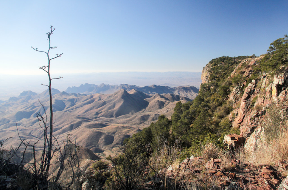
The Dodson Trail would dominate our next day. It basically passes through foothills between the Chisos Mountains and the Sierra Quemada, going steadily uphill to reach one saddle after another. On the right side of the trail, it offered us changing views of the South Rim all day, skirting the Sierra Quemada to our left most of the way.

A panorama of the landscape from the Dodson Trail/Bob Pahre
After reaching the trail’s high point, the trail makes a steady descent to the Homer Wilson Ranch, about a quarter mile below the Ross Maxwell Scenic Drive. The park maintains two large bear boxes here for backpackers to stash water. After picking up two gallons for our next 24 hours, we found a camp at the entrance of Blue Creek Canyon.

This shot makes Blue Creek Canyon look deceptively wide. There really aren't any flat places to camp except on the edge of the wash, which doubles as the trail/Bob Pahre
This proved to be a good choice as the steep canyon walls don’t offer many good campsites until you start to climb out of the canyon. Camping before the canyon also gave us great sightlines and a big, dark night sky. Once again, we could easily see Santa Elena Canyon, a friend on much of this loop.
The next morning offered a steep climb back into the Chisos Mountains. Some stretches exceed a 25 percent incline with little shade, so it’s a challenge in either direction if the sun is out. As you’d expect, an exposed and steep trail also offers great views, both down into Blue Creek Canyon and across into the distance of the Rio Grande Valley and Santa Elena Canyon.

A distant view of Santa Elena Canyon/Bob Pahre
The trail levels out for a splendid jaunt through the woods to Laguna Meadows, where we would spend our last night. This campsite offered the subtle joys of nature instead of the big views we had enjoyed on most days.
Joys of Nature
The Outer Loop takes you through a sample of Big Bend’s habitats, from the Chihuahua Desert floor to the high country of the Chisos Mountains. Boot Canyon holds a surprisingly diverse set of fauna and flora, well described in Roland Wauer and Carl Fleming’s Naturalist’s Big Bend. We found it a joy to hike through this canyon on our first and second days.
On our fourth day, Blue Creek Canyon also offered lovely woods and an ever-changing mix of trees and plants once we started to climb. Between when we left the Chisos at Juniper Canyon and regained them at Blue Creek Canyon, we spent our time in the desert.

The South Rim of the Chisos Mountains was our friend as we hiked the Dodson Trail on the end of Day 2 and most of Day 3/Bob Pahre
Nature is prickly here. As you would expect, you’ll find a lot of cactus in the desert. But everyone and everything has its defenses – aloes have spines, toads have “horns,” and of course insects and animals have teeth.
We met a Western desert tarantula on our third day. It was headed our way along the wash that provides a trail near Homer Ranch. A former student who loves spiders has since told me that it was a male tarantula looking for a mate; I first learned of his hobby when we came across three black widows in the dark in Canyonlands, but that’s another story.

A Western tarantula in Big Bend National Park/Bob Pahre
While December is hardly prime birding season, we did see and hear many different species. Mexican jays were our constant companions, and we heard a lot of doves even if we didn’t see them. We also saw a surprising number of northern harriers above the Dodson Trail.
There were many songbirds in the shrubs, though they didn’t always make themselves visible for identification. They provided the main soundtrack for the Outer Loop, however. When they settled down for the night we had not just dark skies but a silent soundscape.
Water in the desert
Nature’s diversity on the Outer Loop reflects not just changes in elevation or the difference between being exposed to the sun or shaded in a canyon. Water clearly shapes both the terrain and the habitats – a message we saw along a wall in Boot Canyon, with ferns in a moist pour-off right next to cactus.

Add a little water to the desert, and who knows what you might find? Seen on the Boot Canyon Trail along the descent from Toll Pass/Bob Pahre
Water was also central to our planning. The desert rule of thumb is to pack a gallon a day for each person, and consider more when it’s hot. We based our plans on the full gallon, and tried to drink at a steady pace. As it turns out, we drank too little on Day 1, just the right amount on Day 2, and gorged on Day 3 knowing that we had our water cache ahead of us.

Though it was 17°F overnight, our water pouches stayed unfrozen in the tent, and the bottles stayed almost all liquid in the tent's vestibule/Bob Pahre
The route has some ephemeral water sources, one of which we could have used easily and one would have been available at need. A solo hiker we met who was running low on water took a pass on the iffy source. That gives you an idea of how attractive it was. The park does not want you to plan on any finding any water at all, so I will skip further details.

The park likes to say that all the water sources are always dry, so that you'll bring enough water of your own. That's good advice, but we did find two water sources in December. Fresno Creek was running about 3-4 inches wide and a couple of inches deep. This seemingly-unnamed creek in Boot Canyon, above Boot Spring, had pools of sometimes-frozen standing water. They were popular with birds and presumably other wildlife, and likely to have feces of various kinds/Bob Pahre
Hiking hot and cold
Big Bend reaches deadly temperatures in summer, especially around Rio Grande Village. Backpacking in December avoided the heat, and we spent our days hiking in pleasantly cool weather with bright sun. We might put on a shell or fleece when resting in the shade, but hiking uphill into the sun, as we did on a late afternoon on the Dodson Trail, was pretty hot.
Daytime temperatures in the desert reached well into the 60s, which was plenty warm with a bright sun. Our lowest temperature was 17° F overnight on the South Rim. Bringing enough layers to handle those swings comfortably adds more weight to your pack.
The National Park Service is right to warn people about the challenges of the trail. We met one party who bailed at Homer Ranch, and another who was thinking about doing the same. Both groups could get out on their own power, but the park does have to rescue people here. If you don’t have desert experience, don’t become one of those people who needs a rescue.
That said, the Outer Loop offers an outstanding backpacking experience in a great, undervisited park – if you have desert backpacking experience and if you know that you can manage the challenges. If you don’t have that experience, try an overnight from the Homer Wilson Ranch or in the high country of the Chisos Mountains. Either, or both, will give you a good sample of the Outer Loop experience.
Whatever you choose, plan carefully to enjoy the magnificent scenery and natural diversity of a remarkable park.
Robert Pahre is a professor at the University of Illinois, where he teaches and writes about environmental policy and national parks. When not sheltering at home in a pandemic, he regularly takes students on field experiences to national parks both near and far.
Stories about:
Story Categories:
A copy of National Parks Traveler's financial statements may be obtained by sending a stamped, self-addressed envelope to: National Parks Traveler, P.O. Box 980452, Park City, Utah 84098. National Parks Traveler was formed in the state of Utah for the purpose of informing and educating about national parks and protected areas.
Residents of the following states may obtain a copy of our financial and additional information as stated below:
- Florida: A COPY OF THE OFFICIAL REGISTRATION AND FINANCIAL INFORMATION FOR NATIONAL PARKS TRAVELER, (REGISTRATION NO. CH 51659), MAY BE OBTAINED FROM THE DIVISION OF CONSUMER SERVICES BY CALLING 800-435-7352 OR VISITING THEIR WEBSITE. REGISTRATION DOES NOT IMPLY ENDORSEMENT, APPROVAL, OR RECOMMENDATION BY THE STATE.
- Georgia: A full and fair description of the programs and financial statement summary of National Parks Traveler is available upon request at the office and phone number indicated above.
- Maryland: Documents and information submitted under the Maryland Solicitations Act are also available, for the cost of postage and copies, from the Secretary of State, State House, Annapolis, MD 21401 (410-974-5534).
- North Carolina: Financial information about this organization and a copy of its license are available from the State Solicitation Licensing Branch at 888-830-4989 or 919-807-2214. The license is not an endorsement by the State.
- Pennsylvania: The official registration and financial information of National Parks Traveler may be obtained from the Pennsylvania Department of State by calling 800-732-0999. Registration does not imply endorsement.
- Virginia: Financial statements are available from the Virginia Department of Agriculture and Consumer Services, 102 Governor Street, Richmond, Virginia 23219.
- Washington: National Parks Traveler is registered with Washington State’s Charities Program as required by law and additional information is available by calling 800-332-4483 or visiting www.sos.wa.gov/charities, or on file at Charities Division, Office of the Secretary of State, State of Washington, Olympia, WA 98504.
Comments
I've done day hikes to Emory Peak & the South Rim (described in the Falcon Guide as "the classic Texas hike") but never had the time nor the energy for the Outer Loop. As today's popular saying goes, that ship has sailed. But through this well-written and photographed article, I've gained a greater sense of what I missed... and now want more than ever to return to Big Bend. Thanks very much for sharing.
Thank you, SonoraDick. I'm glad you enjoyed it - and there are still some easier-access points beyond the Homer Wilson Ranch (in two directions), for example. Enjoy your next trip to Big Bend!
Thank you for reviewing the need for hikers to bring plenty of water when exploring the trails of Big Bend NP. Even the easiest Trails can challenge one's thirst. Yes, desert trails are very different then hiking in a forest. Besides a need for extra water an ability to navigate without many trail signs is helpful. Thanks again for a great story. PT
Thanks, Paul. This was a case where a "travelogue" really needs to come with warnings. Dodson got pretty warm even in December.
Wonderful to see this detailed trail report on National Parks Traveler. I've done many a day hike in Big Bend, and I dabble at backpacking, but there's no way this 63 yr. old grandma could carry all that water weight. Good warning for all of us. Thanks to the author for an excellent report. Thanks to NP Traveler for including this type of article. A big thumbs up from this avid hiker.
Thanks, GlacierGirl, I'm glad you enjoyed it! The Traveler has been very supportive of these kinds of articles from on the much-less-well-beaten tracks.