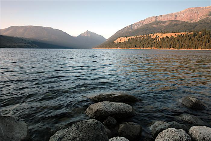
Formed by a glacial retreat, Wallowa Lake near Joseph, Oregon, marks the start of the Nez Perce Trail / Scott Johnson
In the remote reaches of northeast Oregon, beauty, recreation, geology, and history converge at a blue gem nestled at the foot of the Wallowa Mountains.
Wallowa Lake, with its postcard views and popular campground, draws fishermen and swimmers, hikers and horseback riders to the gateway of the Eagle Cap Wilderness. Created by glacial deposit around 17,000 years ago, an incredibly preserved 3-mile-long moraine along the lake’s east shore shows the path of the glacier clear as day. Across the water, Chief Joseph Mountain looms above.
And on a hill that overlooks the northern outlet of Wallowa Lake sits a stone pillar. The gravesite marks the final resting ground for Tuekakas, commonly known as Old Chief Joseph. He signed a treaty with the U.S. government in 1855 to secure this sacred valley for his people, the Nez Perce. Less than a decade later, however, the federal government wanted to take ownership of much of that land, including the Wallowa Valley, and confine the Nez Perce to a reservation in Idaho.
The Joseph band of Nez Perce never signed this treaty and refused to leave. By 1877, Old Chief Joseph had passed away and tensions with settlers had risen to the point where the Army was called in to remove the tribes. Old Joseph’s son, Young Chief Joseph, chose to flee along with the other “non-treaty” chiefs. Their 1,170- mile retreat from Army pursuit and ultimate surrender just south of the Canadian became known as the Nez Perce War.
This route, beginning at Wallowa Lake, is now commemorated as the Nez Perce National Historic Trail. The trail includes or passes through many sites managed by the National Park Service, including Old Chief Joseph Gravesite and Cemetery, Big Hole National Battlefield, Yellowstone National Park, and Bear Paw Battlefield.
It is one of 30 trails authorized by Congress under the National Trails System Act.
That act was signed into law 50 years ago by President Lyndon B. Johnson “to promote the preservation of, public access to, travel within, and enjoyment and appreciation of the open-air, outdoor areas and historic resources of the Nation.” The law designated the country’s two most well-known long-distance hiking trails—the Appalachian and Pacific Crest national scenic trails—as foundations for a nationwide system, and set out a framework for adding new trails.
Ten years later, the act was amended to include trails of historic significance, like the Nez Perce Trail, which was designated in 1986. The National Trails System now includes 11 National Scenic Trails and 19 National Historic Trails, many administered by the National Park Service, covering 55,000 miles in 49 states.
Just as importantly, the act called for a system to “provide a variety of outdoor recreation uses in or reasonably accessible to urban areas.” There are now more than 1,200 trails, including 21 National Water Trails, in all 50 states, as well as the District of Columbia and Puerto Rico, serving hikers, bikers, paddlers, equestrians, skiers, ATV riders, and more. In 1983, the act was again amended to allow unused rail corridors to be converted into trails.
The National Trails System now fulfills President Johnson’s vision for 100,000 miles of trails. These pathways take us to some of the most awe-inspiring vistas on the planet. To set foot on a national scenic trail indulges a sense of exploration, passion, and perseverance. Yet these same traits describe our national historic trails, often built out of necessity, not for leisure. They are the stories of America, meant to help us escape and reflect, to inspire and challenge us.
Whereas three other national historic trails—California, Lewis and Clark, and Oregon—honor the migration to and exploration of Oregon and the West Coast, the Nez Perce National Historic Trail preserves a struggle to leave, a forced departure after a betrayal of contract. The trails shine light on the ugly as well as the beautiful.
That is a testament to the value of the National Trails System. This golden anniversary is a golden opportunity to take a walk through history.
National Historic Trails
Step (or paddle, or ride dogsled) into history at the 19 national historic trails, from 56 to 5,600 miles, preserved under the National Trails System.
Length: 175 miles
State: Hawaii
The trail preserves, protects, and interprets traditional Native Hawaiian culture and natural resources, traversing hundreds of ancient settlement sites and more than 200 ahupua'a (traditional sea to mountain land divisions).
Length: 5,600 miles
States: CA, CO, ID, KS, MO, NE, NV, OR, UT, WY
In the mid-1800s, more than 250,000 people traveled to the gold fields and rich farmlands of California to seek their fortunes in one of the largest mass migrations in American history.

The Chesapeake Bay and Alaska's outback, home of the Iditarod, are among the national trails/NPS and BLM
Length: 3,000 miles
States: VA, MD, DE, DC, PA, NY
Between 1607 and 1609, John Smith and his crew mapped nearly 3,000 miles of Chesapeake Bay and nearby rivers, and documented American Indian communities. He helped ensure the success of early English colonization efforts.
Length: 2,600 miles
States: TX, LA
During the Spanish colonial period in America, this “royal road” provided the only primary overland route from what is now Mexico across the Río Grande to the Red River Valley in what is now Louisiana.
El Camino Real de Tierra Adentro
Length: 404 miles
States: NM, TX
This “royal road” is a symbol of the early cultural interaction between nations and multiple ethnic groups in the American Southwest. The commercial and social exchanges that occurred over the centuries helped create the rich cultural mix that is still present today.
Length: 2,350 miles
State: AK
An important artery of Alaska’s winter commerce during the Gold Rush Era, the trail served a string of mining camps, trading posts, and other settlements founded between 1880 and 1920.
Length: 1,200 miles
States: AZ, CA
In 1775-76, Juan Bautista de Anza led some 240 men, women, and children on an epic journey to establish the first non-Native settlement at San Francisco Bay.

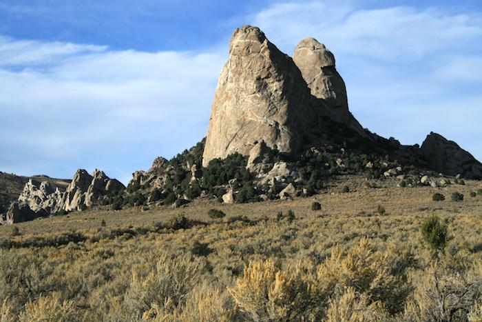
The “Twin Sisters” in City of Rocks National Preserve in Idaho along the California Trail were a landmark used by immigrants between 1843 and 1882 / NPS
Length: 3,700 miles
States: ID, IL, IA, KS, MO, MT, NE, ND, OR, SD, WA
Between May 1804 and September 1806, the Corps of Discovery traveled from the plains of the Midwest to the shores of the Pacific Ocean. In their search for a water route to the Pacific, they opened a window into the west for the young United States.
Length: 1,300 miles
States: IL, IA, NE, UT, WY
See the route 70,000 Mormons took from Nauvoo, Illinois, to Salt Lake City to escape religious persecution in the mid-1800s.
Length: 1,170 miles
States: ID, OR, MT, WY
Forced to abandon hopes for a peaceful move to the Lapwai reservation, Nez Perce chiefs saw flight to Canada as their last promise for peace. Pursued by the Army, most surrendered just 40 miles from the border.
Length: 2,700 miles
States: AZ, CA, CO, NV, NM, UT
New Mexican traders moved locally produced merchandise across what are now six states to exchange for mules and horses.
Length: 2,170 miles
States: ID, KS, MO, NE, OR, WA, WY
Wagon ruts that can still be seen serve as reminders of the sacrifices, struggles, and triumphs of early American settlers who sought the promise of lush farmlands and a new beginning in the West.
Length: 330 miles
States: NC, SC, TN, VA
Follow the route used by patriot militia during the pivotal Kings Mountain campaign of 1780 during the fight for independence.
Length: 2,000 miles
States: CA, CO, KS, MO, NE, NV, UT, WY
Before the invention of the telegraph, young men rode horses and used a relay system to carry mail from Missouri to California in an unprecedented 10 days.
Length: 1,203 miles
States: CO, KS, MO, NM, OK
In 1821, the trail became America's first great international commercial highway, linking Missouri to New Mexico and promoting western expansion.

In Santa Fe you can find a sculpture recalling the settlers who followed the Old Spanish Trail / NPS
Length: 54 miles
State: AL
In 1965, 25,000 people, led by Dr. Martin Luther King Jr., peacefully marched to extend equal voting rights to African Americans. It was one of the defining moments of the civil rights movement.
Length: 290 miles
States: DC, MD, VA
The trail tells the stories of the events, people, and places that led to the birth of our National Anthem.
Length: 5,045 miles
States: AL, AR, GA, IL, KY, MO, NC, OK, TN
The Cherokee people, forcefully removed from their homelands in Georgia, Alabama, and Tennessee, traveled by foot, horse, wagon, or steamboat to live in Indian Territory, now Oklahoma.
Washington-Rochambeau Revolutionary Route
Length: 1,000 miles
States: MA, RI, CT, NY, NJ, PA, DE, MD, VA, DC
In 1781, the French Army joined forces with the Continental Army to fight the British Army in Yorktown, Virginia. The effort and cooperation between the two sides led to a victory at Yorktown and secured American independence.


Add comment