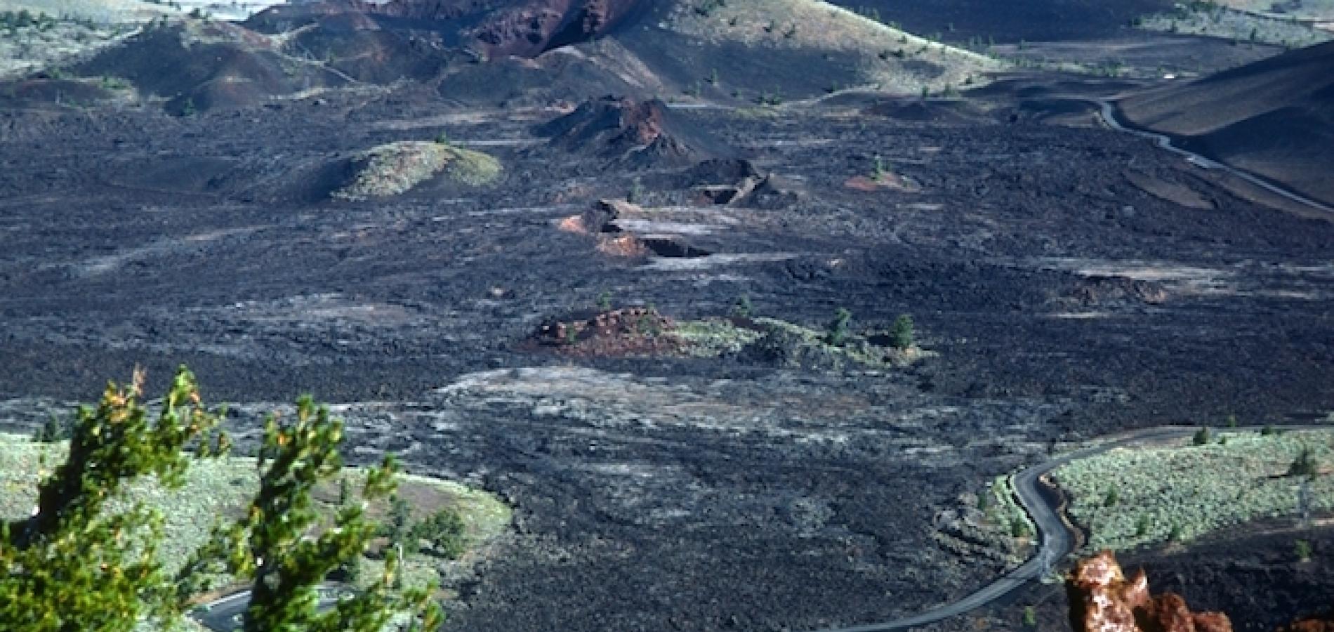
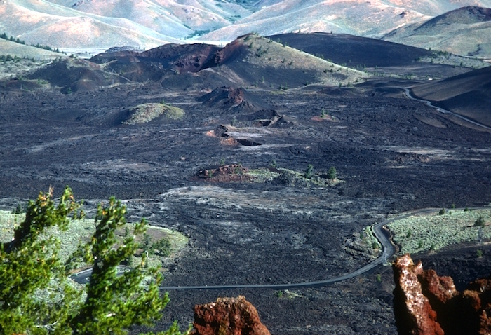
Over the years, in visits to national monuments, this question seldom occurred to me. Walking the lava at Craters of the Moon National Monument, canoeing the Missouri River in the Upper Missouri River Breaks, kayaking and hiking Glacier Bay while it was still a monument and before it gained national park status, I gave little thought to where the monument boundaries were and why they were there. The boundaries must have been drawn to protect what is of value here. Monument status was protecting the beauty, history, wildlife, even wilderness, so we visitors were happy. How naïve!
Now, as 27 national monuments proclaimed by Presidents Clinton, Bush, and Obama under the Antiquities Act are under review by the Trump administration, I’m thinking of where the boundaries were drawn for these monuments I so much enjoyed, and why. The Trump administration may try to rescind some monuments altogether, but more likely the recommendations will be to shrink and fragment monuments, such as Grand Staircase/Escalante and Bears Ears, so as to open more land to coal mining and other development. In his initial comment about the decision on Bears Ears, Interior Secretary Zinke has said he will recommend this monument be downsized. Presidents have reduced monuments before – Woodrow Wilson did that to Mt. Olympus National Monument in 1915, so monument reduction may be possible. Of course, in the Mt. Olympus National Monument case, the monument became Olympic National Park, and was greatly enlarged.
Section 2 of the Antiquities Act of June 8, 1906 states, “That the President of the United States is hereby authorized, in his discretion, to declare by public proclamation historic landmarks, historic and prehistoric structures, and other objects of historic or scientific interest that are situated on lands owned or controlled by the Government of the United States to be national monuments, and may reserve as a part thereof parcels of land, the limits of which in all cases shall be confined to the smallest area compatible with the proper care and management of the objects to be protected….”
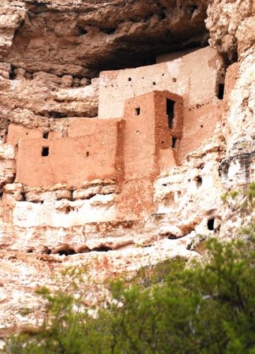
In the coming fight over monuments the word “discretion” and the phrase “smallest area compatible with the proper care and management” will be the core of many arguments, as they have been through most of the history of the Antiquities Act. Last fall, visiting Arizona’s Tuzigoot and Montezuma Castle national monuments, the former a pueblo ruin, the latter a cliff dwelling and both quite small, the “smallest area compatible” issue seemed straightforward, though I later learned that Montezuma Castle has had many boundary changes in its history. When Theodore Roosevelt declared the original Montezuma Castle monument in 1906, one of the first four declared under the Antiquities Act, drawing a boundary to protect the cliff dwelling seemed straightforward, but over the years archaeological work revealed natural and cultural resources important to the dwelling’s story, so Congress expanded the monument. Drawing a boundary around a small site like this is not as simple as it seemed to me in my visit to Montezuma Castle.
Deciding what should be in large monuments like Grand Canyon (originally a national monument), Glacier Bay (the current national park and preserve grew from a monument), and Bears Ears depends on many factors that lead to disagreements and controversy. Decisions need to be made about what is to be protected, what the threats to resources at issue might be, and measures like boundary lines that will achieve the goals agreed upon for the monument.
Every monument case is different, of course, and where to draw a boundary requires analysis and judgment, but some reasons for boundary decisions apply in many cases. Scenery is often involved to protect an outstanding scenic vista from development that would affect its beauty and lessen the pleasure and inspiration of the viewer. Sometimes the wildness of a landscape is at issue, an area without roads, a place where silence and solitude can be enjoyed. Or maybe it’s a rich watershed with riparian areas that need protection from cattle so wildlife can flourish. A boundary may be drawn specifically to exclude a proposed development such as an open pit mine that would affect many other resource values of the landscape.
Critics contend that monuments like Bears Ears and Grand Staircase/Escalante in Utah are too large. Shrink the boundaries or carve up the monument into the “smallest area” necessary for care and management. Such critics disagree with decisions about what was to be protected and what measures are necessary to achieve protection. Estimates are that mroe than 100,000 archaeological sites are scattered through the Bears Ears monument. At issue is the best way to protect these treasures – by including them in a large preserve or by creating small preserves around important sites or clusters of sites. Which approach will best achieve the goal to care for one of the richest concentrations of archaeological treasures in the United States?
There is also the issue of the religious and spiritual value of such a place for the descendants of the ancients who lived on this landscape. Native Americans regard the Bears Ears area as a sacred landscape, and “smallest” is certainly the wrong yardstick to apply to protection of such spiritual value. Responding to Secretary Zinke’s decision to recommend changes in Bears Ears National Monument, the Bears Ears Intertribal Coalition issued a statement that reads, in part, “The Bears Ears region is not a series of isolated objects, but the object itself, a connected, living landscape, where the place, not a collection of items, must be protected. You cannot reduce the size without harming the whole. Bears Ears is too precious a place, and our cultures and values too dignified and worthy, to backtrack on the promises made in the Presidential Proclamation.” Reading this raises the question of whether protecting only the altar in a Christian cathedral is “compatible with the care and management” of such sacred space, or if we must preserve the whole edifice. The answer seems obvious.
There is no denying that boundaries are meant to exclude some activities. Intrusive, large-scale development like oil and gas, coal and mineral mining are to be excluded. Recreation and tourism, archaeological preservation, wilderness, and scenic values are simply incompatible with industrial development. Oil well pads and pumpjacks scattered among scenic mesas and ancient ruins damage entirely the experience of such places. Many established uses like livestock grazing and traditional firewood and plant gathering are allowed in national monuments, as are hunting, ORV travel, bicycling and rock climbing. More regulation of such activity may occur inside a monument boundary than outside of it, for instance limiting where cows and ORVs can go to protect other resources. I live near the Rio Grande del Norte National Monument in northern New Mexico, and the BLM managers here have negotiated arrangements about multiple use in the monument to the satisfaction of everyone and, within limits, the monument boundary is more inclusive than exclusive.
Congress granted presidents the right to exercise their judgment as to what action should be taken to care for areas of prehistoric, historic, or scientific “interest” on public lands. Presidents could exercise their “discretion” in such matters, and doing so has required decisions regarding how much land should be set aside to achieve the goal of care and management of the “interest” concerned.
Reasonable people have disagreed about how much acreage is enough, and in most cases a compromise or consensus has been reached. In the case of Bears Ears, for instance, the intertribal coalition proposal aimed for a national monument of 1.9 million acres. Utah politicians attempted to substitute what they called the Public Lands Initiative for any monument designation, but could not move a bill to achieve this through Congress. The Obama administration, after consultation with many stakeholders, decided on a monument of 1.3 million acres. Boundaries were drawn around areas of special concern to local residents. The process that led to the ultimate decision and the drawing of boundaries took years.
President Clinton’s Secretary of the Interior, Bruce Babbitt, established what has been described as his “no surprises” policy after the blowback the Clinton administration received from Utah politicians over the 1996 proclamation of the Grand Staircase/ Escalante National Monument. He pledged to visit any area being considered for monument status, to meet with locals about different strategies for protecting the area in question, and to give local congressmen and senators the opportunity to push legislation to protect the area. He would do this before he made any recommendation regarding a national monument. Babbitt followed this policy.
Several areas were protected in lieu of monument designation, among them Steens Mountain Cooperative Management Area in eastern Oregon and Black Rock Desert in Nevada. The point here is that most of the national monuments under review are the result of processes that involved extensive public input, on-the-ground review, agency input, and compromise. Some boundary adjustments in these monuments may be reasonable, but we hope for processes like those that established monument boundaries to make any decisions about adjusting them.
At this time only one “recommendation” has come from the national monument review – that the Bears Ears National Monument be reduced and broken up into smaller pieces.
“There is no doubt that it is drop-dead gorgeous country and that it merits some degree of protection, but designating a national monument that – including state land – encompasses almost 1.5 million acres where multiple-use management is hindered or prohibited is not the best use of the land and is not in accord with the intention of the Antiquities Act,” said Interior Secretary Zinke in his 45-day interim report. That Zinke arrived at this conclusion after only one-and-a-half months of “review” suggests that adequate process is a vain hope. The goal of the “review” is to reduce or rescind national monuments that, in the view of the Trump administration, stand in the way of “multiple-use management.”
In Section 1 of his executive order on “Designations Under the Antiquities Act,” President Trump states that
Monument designations that result from a lack of public outreach and proper coordination with State, tribal, and local officials and other relevant stakeholders may also create barriers to achieving energy independence, restrict public access to and use of Federal lands, burden State, tribal, and local governments, and otherwise curtail economic growth. Designations should be made in accordance with the requirements and original objectives of the Act and appropriately balance the protection of landmarks, structures, and objects against the appropriate use of Federal lands and the effects on surrounding lands and communities.
In Section 2 he orders a report within 120 days that “shall include recommendation for such Presidential actions, legislative proposals, or other actions consistent with the law as the Secretary may consider appropriate to carry out the policy set forth in Section 1 of this order.” The “policy” is to “balance” Antiquities Act protection with other “appropriate use of Federal lands” dedicated to economic growth. Implicit in the “policy” is the assumption, certainly espoused by the Utah congressional delegation and that state’s governor, who have been the advocates and drivers of this review, that economic growth should trump all other goals and land values at Bears Ears and perhaps in the other twenty-three monuments under review. What a massive task Trump has given Secretary Zinke and only 120 days to do it!
Stories about:
Story Categories:
A copy of National Parks Traveler's financial statements may be obtained by sending a stamped, self-addressed envelope to: National Parks Traveler, P.O. Box 980452, Park City, Utah 84098. National Parks Traveler was formed in the state of Utah for the purpose of informing and educating about national parks and protected areas.
Residents of the following states may obtain a copy of our financial and additional information as stated below:
- Florida: A COPY OF THE OFFICIAL REGISTRATION AND FINANCIAL INFORMATION FOR NATIONAL PARKS TRAVELER, (REGISTRATION NO. CH 51659), MAY BE OBTAINED FROM THE DIVISION OF CONSUMER SERVICES BY CALLING 800-435-7352 OR VISITING THEIR WEBSITE. REGISTRATION DOES NOT IMPLY ENDORSEMENT, APPROVAL, OR RECOMMENDATION BY THE STATE.
- Georgia: A full and fair description of the programs and financial statement summary of National Parks Traveler is available upon request at the office and phone number indicated above.
- Maryland: Documents and information submitted under the Maryland Solicitations Act are also available, for the cost of postage and copies, from the Secretary of State, State House, Annapolis, MD 21401 (410-974-5534).
- North Carolina: Financial information about this organization and a copy of its license are available from the State Solicitation Licensing Branch at 888-830-4989 or 919-807-2214. The license is not an endorsement by the State.
- Pennsylvania: The official registration and financial information of National Parks Traveler may be obtained from the Pennsylvania Department of State by calling 800-732-0999. Registration does not imply endorsement.
- Virginia: Financial statements are available from the Virginia Department of Agriculture and Consumer Services, 102 Governor Street, Richmond, Virginia 23219.
- Washington: National Parks Traveler is registered with Washington State’s Charities Program as required by law and additional information is available by calling 800-332-4483 or visiting www.sos.wa.gov/charities, or on file at Charities Division, Office of the Secretary of State, State of Washington, Olympia, WA 98504.
Comments
Excellent piece, John. NPT readers ought to be aware of your book, Wilderness in the National Parks: Playground or Preserve, which gives much more of the history of efforts to protect wild lands within national monuments and national parks. Your essay also brings to mind the conflict over the creation of Canyonlands National Park in the early 1960s. That was an acrimonious, three-year-long process involving the same political forces which hold sway in Utah today. The Park Service began with an idea for a million-acre, rim-to-rim national park in the Canyonlands Basin, but was forced to accept a park one-quarter that size when Senator Frank Moss's bill was passed in 1964 (the park was enlarged to 337,600 acres in 1971). At one point in the legislative deliberations, Utah Sen. Wallace Bennett proposed a park of only 11,000 acres (that's not a typo!) consisting of three units: the Needles, Grand View Point-Upheaval Dome, and Land of Standing Rocks. That approach sounds eerily like the one Secretary Zinke is recommending, and the current Utah congressional delegation may adopt. We are fortunate that so limited a vision of a Canyonlands park was not adopted, and we must hope (and insist) that Congress take a more generous and broad-minded view of Bears Ears as well.