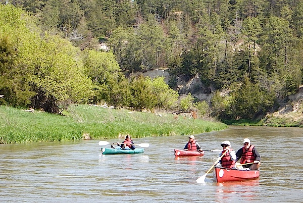
Kayaks and canoes are the crafts most folks use to float the Niobrara National Scenic River/David and Kay Scott
The Niobrara River flows eastward 535 miles from the high plains of Wyoming to its confluence with the Missouri River in northeastern Nebraska. Over its course the river cuts through nearly the entire width of northern Nebraska, much of which is in the state's scenic Sandhills region. Unlike most rivers that are fed by rainwater runoff, nearly three-quarters of the Niobrara's flow is the result of groundwater from the vast Ogallala Aquifer.
The Nebraska Sandhills are simply stunning. Twenty-thousand square miles of grass-covered sand roll and flow as far as the eye can see, interrupted only by an occasional home or small town. The Sandhills act like a giant sponge that absorbs most of the rainfall that percolates down to the water table. This semi-arid region with little topsoil is quite fragile and unable to sustain row crops, but its hardy grass cover is ideal for ranching. Twenty to 30 acres of land are required for each cow, and ranches can run into the tens of thousands or even hundreds of thousands of acres. Ted Turner is the owner of five Nebraska ranches that total 430,000 acres. Nebraska's cattle production is exceeded only by that of Texas. The state has three times as many head of cattle as it does people.

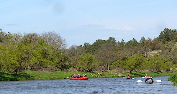
The landscape along the Niobrara River is constantly changing/David and Kay Scott
Seventy-six miles of the Niobrara River beginning just east of the town of Valentine, Nebraska, were designated in 1991 as part of the National Wild and Scenic Rivers System. The first half of this section is where nearly all the canoeing, rafting, kayaking, and tubing take place. It is also where all of the over one dozen outfitters are located. Further east the river flow ebbs as irrigation takes water from the river and aquifer.
The national river's initial ten-mile stretch winds through Fort Niobrara National Wildlife Refuge, where the first five miles are closed to visitors in an effort to protect wildlife habitat. Thus, most floaters put in a little east of Valentine at the Fort Niobrara Launch. Once out of the wildlife refuge (where alcohol use is prohibited), nearly all land bordering the river is in private ownership and floaters are asked not to trespass. Exceptions include Smith Falls State Park, approximately 15 miles downstream, and take-out points along public roads.
Although water levels in the river are typically highest from April through mid-June, floating is most popular from mid-June through Labor Day when outdoor temperatures are warmer and there is less precipitation. We were told by one outfitter that families should generally avoid floating weekends from mid-July to mid-August when the river is typically crowded and some unseemly antics including occasional nudity may occur.
River time can be hard to beat./Kay and David Scott
Some members of our group chose kayaks while others preferred to float in a large raft steered by a guide. The two of us chose to canoe the three-hour stretch from Fort Niobrara Launch to the take-out at Smith Falls State Park, where we picnicked. Any of the three modes of transport, or even tubes, would have been fun as the river current made the trip less than strenuous. The kayakers often chose to pull up their paddles and drift with the current. We occasionally did the same with our canoe.
Canoes, kayaks, and tubes typically rent for about $30 per person and float times can range from 2 to 8 hours depending upon the take-out point. Tubes typically require about twice as much time as canoes and kayaks to cover the same distance. River conditions and a list of outfitters are available from links on the river's National Park Service website.
Story Categories:
A copy of National Parks Traveler's financial statements may be obtained by sending a stamped, self-addressed envelope to: National Parks Traveler, P.O. Box 980452, Park City, Utah 84098. National Parks Traveler was formed in the state of Utah for the purpose of informing and educating about national parks and protected areas.
Residents of the following states may obtain a copy of our financial and additional information as stated below:
- Florida: A COPY OF THE OFFICIAL REGISTRATION AND FINANCIAL INFORMATION FOR NATIONAL PARKS TRAVELER, (REGISTRATION NO. CH 51659), MAY BE OBTAINED FROM THE DIVISION OF CONSUMER SERVICES BY CALLING 800-435-7352 OR VISITING THEIR WEBSITE. REGISTRATION DOES NOT IMPLY ENDORSEMENT, APPROVAL, OR RECOMMENDATION BY THE STATE.
- Georgia: A full and fair description of the programs and financial statement summary of National Parks Traveler is available upon request at the office and phone number indicated above.
- Maryland: Documents and information submitted under the Maryland Solicitations Act are also available, for the cost of postage and copies, from the Secretary of State, State House, Annapolis, MD 21401 (410-974-5534).
- North Carolina: Financial information about this organization and a copy of its license are available from the State Solicitation Licensing Branch at 888-830-4989 or 919-807-2214. The license is not an endorsement by the State.
- Pennsylvania: The official registration and financial information of National Parks Traveler may be obtained from the Pennsylvania Department of State by calling 800-732-0999. Registration does not imply endorsement.
- Virginia: Financial statements are available from the Virginia Department of Agriculture and Consumer Services, 102 Governor Street, Richmond, Virginia 23219.
- Washington: National Parks Traveler is registered with Washington State’s Charities Program as required by law and additional information is available by calling 800-332-4483 or visiting www.sos.wa.gov/charities, or on file at Charities Division, Office of the Secretary of State, State of Washington, Olympia, WA 98504.
