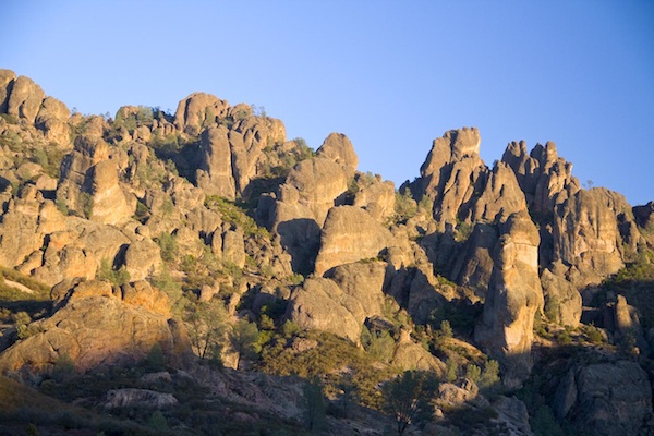
The towering rock formations along Machete Ridge in Pinnacles National Park glow golden in the afternoon sun. George Oxford Miller photo.
Pinnacles National Park took 125 years to become the nation’s newest designated parkland. But it took immensely longer for the mountains to arrive at the present location 40 miles southeast of Salinas, California.
Teddy Roosevelt made the spectacular towering cliffs and ramparts a national monument in 1908, and in 1933 Franklin Roosevelt dispatched the Civilian Conservation Corps to forge trails and create a reservoir. Finally on January 10, 2013, Congress awarded the scenic wonderland the highest accolade a landscape can receive, redesignating it as a "national park" instead of a "national monument."
The park straddles the San Andreas Fault and preserves 26,000 acres (including 16,000 acres of officially designated wilderness) of rolling hills, deep canyons, and towering mountain ridges with precipitous cliffs.
The continent’s largest bird, the endangered California condor, and largest amphibian, the endangered red-leg frog, and 536 native species of flowering plants find refuge in the compacted patchwork of critical habitats.
No east-west roads cross the pristine wilderness. From the east, Highway 146 via Highway 25 south from Hollister leads into the park. To the west entrance, Highway 146 off Highway 101 south of Salinas narrows from two lanes to one.
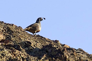
The elegant California Quail lives in the chaparral grasslands in Pinnacles National Park. George Oxford Miller photo.
The winding road gives no hint of the majestic scenery ahead. Blue oaks and scrubby chaparral cover the undulating hills that separate the low Gabilan and San Lucia mountains of the Pacific Coast Range.
During a recent visit, only brushstrokes of yellow from fall-colored vineyards interrupted the rich browns of grasses that carpet the valley.
Over 30 miles of hiking trails lead into the hills, canyons, cliffs, and palisades. For an introduction to the dramatic scenery and the varied habitats preserved in the park, we start out on the easy 2.4-mile Balconies Cave loop in the western sector. The trail begins in the classic chaparral habitat that defines central California foothills.
The rusty fall flower-heads of brushy California Buckwheat, white in spring, line the trail and blue oaks and sycamore trees provide broken shade. As we hike along the dried stream bed of Chalone Creek, park Ranger Lupe Zaragosa gives us the scoop on the wandering route of the strangely mobile mountains.
“A huge volcanic field erupted 25-million years ago and deposited a lava bed 8,000-feet thick, 15 miles long, and eight miles wide,” she tells us. “Then the San Andreas Fault formed and split the lava field. About two-thirds drifted with the Pacific Plate as it inched northward. Geologists found identical rocks 200 miles south near Lancaster.”
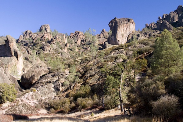
Eroded, free-standing rock formations give the nation's newest national park its name. George Oxford Miller photo.
With 25 million years to sculpt the original lava landscape, erosion’s scalpel sliced away several thousand feet of mountaintop, leaving the bizarre formations and sheer ridges that tower above the canyon trail. The rubble accumulated to form the surrounding undulating hills of chaparral, grasslands, and in recent decades, world-renowned vineyards.
Park naturalist and avid rock climber Gavin Emmons joins the hike to tell us about the unique features of the park’s biology. A 400-foot tall, knife-edge cliff dominates the horizon.
“That’s Machete Ridge,” he says. “Climbing has been a tradition in the park since the 1950s. More than 900 routes scale Machete Ridge and Balconies Ridge across the canyon.”
As we gaze upward at the daunting cliff, a large, black bird soars into view. Gavin jerks up his binoculars. “It’s a condor! See the red head and white under its wings?”
We follow its path circling over the ridge. Even at the distance, the 9-foot wingspread looks impressive. “We’ve released 30 California condors in the Pinnacles,” he says. “Another 30 are established over at Big Sur. They frequently fly back and forth.”
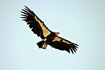
A released population of 30 endangered California Condors, the largest bird in North America, soars in the sky above Pinnacles National Park. George Oxford Miller photo.
The goal for a captive released population is to become successful breeders. The Big Sur colony fledges chicks every year, but not the Pinnacles birds. Pairs have tried but one chick fell out of the nest and broke its wing. Others died of poisoning from lead shot used by hunters or plastic chunks fed to them by the parents.
“The plastic looks like bone shards, part of their natural diet,” Gavin explains. “We try to educate the public not to litter or use lead shot, and most people are very receptive. We also provide supplemental food weekly to be sure the birds get lead-free food.”
When the trail seems to end in a jumble of boulders, Gavin puts on his headlamp.
“The park has several talus caves formed by massive rock slides,” he says. “This one is easy but it’s deep enough to be totally dark. It has a colony of large-eared bats in the summer, but most move on by winter.”
We scramble around car- to house-sized boulders until no trace of light remains, then emerge along a stretch of flowing creek. The only two bats we see look like brown dots painted on the walls by a Halloween graffiti artist.
Pinnacles National Park offers camping on the east side, but unlike larger parks has no on-site hotels, restaurants, or gift shops. But outside the west entrance, surrounded by hundreds of acres of vineyards, we stay at the Pinnacles B&B and Winery. The Italian-style villa/vineyard has a pool, complementary wine tasting for guests, and a night sky brilliant with sparkling stars.
Compared to California’s world-famous celebrity parks visited by millions, Pinnacles is barely a blip on the radar. Besides unspoiled nature and inspiring scenery, the park offers an even more scarce commodity–solitude. We see only about six people on the trail.
When you plan your trip, double check your GPS coordinates (36º29’13”N 121º10’01”W). The laid-back park is still on the move. At 2 inches per year, it’ll reach Oregon in another million years.
Story Categories:
A copy of National Parks Traveler's financial statements may be obtained by sending a stamped, self-addressed envelope to: National Parks Traveler, P.O. Box 980452, Park City, Utah 84098. National Parks Traveler was formed in the state of Utah for the purpose of informing and educating about national parks and protected areas.
Residents of the following states may obtain a copy of our financial and additional information as stated below:
- Florida: A COPY OF THE OFFICIAL REGISTRATION AND FINANCIAL INFORMATION FOR NATIONAL PARKS TRAVELER, (REGISTRATION NO. CH 51659), MAY BE OBTAINED FROM THE DIVISION OF CONSUMER SERVICES BY CALLING 800-435-7352 OR VISITING THEIR WEBSITE. REGISTRATION DOES NOT IMPLY ENDORSEMENT, APPROVAL, OR RECOMMENDATION BY THE STATE.
- Georgia: A full and fair description of the programs and financial statement summary of National Parks Traveler is available upon request at the office and phone number indicated above.
- Maryland: Documents and information submitted under the Maryland Solicitations Act are also available, for the cost of postage and copies, from the Secretary of State, State House, Annapolis, MD 21401 (410-974-5534).
- North Carolina: Financial information about this organization and a copy of its license are available from the State Solicitation Licensing Branch at 888-830-4989 or 919-807-2214. The license is not an endorsement by the State.
- Pennsylvania: The official registration and financial information of National Parks Traveler may be obtained from the Pennsylvania Department of State by calling 800-732-0999. Registration does not imply endorsement.
- Virginia: Financial statements are available from the Virginia Department of Agriculture and Consumer Services, 102 Governor Street, Richmond, Virginia 23219.
- Washington: National Parks Traveler is registered with Washington State’s Charities Program as required by law and additional information is available by calling 800-332-4483 or visiting www.sos.wa.gov/charities, or on file at Charities Division, Office of the Secretary of State, State of Washington, Olympia, WA 98504.