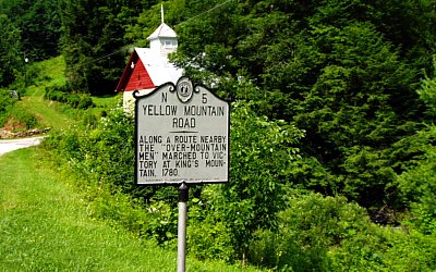
Explore Overmountain Victory National Historic Trail for awesome history and great Southern Appalachian scenery. This NC historical marker signals a trail section that is a colonial road used by the Overmountain men in Avery County, North Carolina. This sign on the Appalachian Trail sits where the militias crossed the mountain at the TN/NC border in similar weather. In late September, 1780, the marchers trudged through significant snow. Photos by Randy Johnson.
It's difficult to experience the past unless you preserve it'and National Historic Trails do that. Sadly, not every one of those paths conveys the past as vividly as seeing ruts left in rock by covered wagons navigating the Oregon Trail.
Case in point'the Overmountain Victory National Historic Trail (OVNHT)'Eastern America's first National Historic Trail.
A Route Worth Retaking
This trail meanders 330 miles through four states following patriot militia as they gathered in September 1780 for the Revolutionary Battle of Kings Mountain, SC. The mounted horsemen from Virginia and Tennessee crossed the Appalachians and joined North Carolinians to trap and defeat loyalists under British Major Patrick Ferguson.
Like so many historical routes'most of the actual path is now under pavement, graded, flattened, and forgotten. But if only walking the same earth trod by these troops makes Memorial Day meaningful for you'a number of original sections of the trail in Western NC and East Tennessee truly demand attention. Two trails featured here are colonial roads that felt the tread of patriot militia.
They're both spots where the trail goes 'over the mountain.'
An Easy Sample of the OVNHT
The 'trail map' for the OVNHT makes it look like a road trip with historic stopping points. Legislation did authorize building a physical path close to the original route, and now, says Superintendent Paul Carson, 'Eighty certified miles of that path exist.'
A "doable" sample of the OVNHT is easy to find. Both of these hikes fit in a less ambitious, less-traveled, part of the trail that packs historic punch'and great scenery. Let's focus a drive between the area of Morganton and Marion NC, on I-40, and Elizabethton, TN, (or beyond to Abingdon, VA), on I-81 in Tennessee. Assuming more people may start from the east, this itinerary goes "backward," from NC to TN.
In either direction, any detour on this 'Overmountain Meander' leads to great attractions.
(Tip: Download the map and follow the route (choose the OVNHT on this page.)
East of the Blue Ridge/ I-40 Area of NC
Quaker Meadows, in Morganton, NC near I-40, was a staging area and campsite for troops under Council Oak on September 30th, 1780. This meadow by the Catawba River was named after a Quaker trader and owned by patriot leaders Colonels Joseph and Charles McDowell. The imposing red brick house built in 1812 by Charles McDowell's son is part of the historic setting.
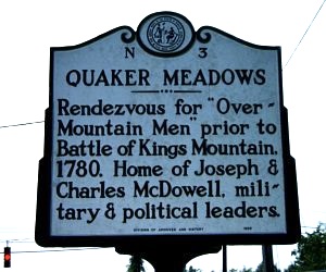
An historical marker in Morganton, NC points out where patriot militiamen gathered after crossing the Blue Ridge.
Then take I-40 west toward Asheville to Marion and head up US 221 to the 1787 Charles McDowell House, one of the last remaining frame structures in western North Carolina and 'the last standing home place in North Carolina for which a county was named.'
Blue Ridge Parkway/Mountain Peaks
Next take NC 226 to the Blue Ridge Parkway and the Museum of NC Minerals in Gillespie Gap. The museum, a premier geological intro to the Appalachians in Yancey County near Spruce Pine, a major mining center, includes a full-size, outfitted figure of an Overmountain militiaman.
Not knowing where Ferguson's army was, and with two major valleys below the Blue Ridge, the Overmountain Men split up so they'd be sure to interdict Ferguson's march if he was heading to the mountains. They had reason to be wary. The militia had formed in the first place to counter Ferguson's direct threat to destroy their mountain homes.
Walk an atmospheric portion of the old route, by taking the Parkway north five miles to Heffner Gap Overlook (Milepost 326). Cross the road into the woods by the OVNHT marker down the Rose River Trail. This gradual 1.3-mile downhill hike (turn around and return for a 2.6-miler) follows an atmospheric route in use since colonial days.
The road is likely wider now than when the Overmountain Men flowed past on horseback, but it's the real thing.
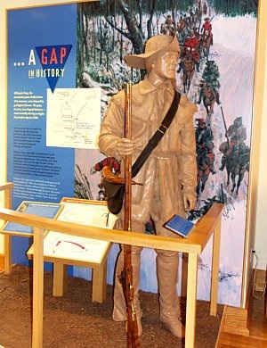
This exhibit at the Museum of NC Minerals depicts the buckskin garb so typical of the Overmountain men and the Appalachian frontier.
This portion of the OVNHT on the 534-acre Rose Creek tract, just dedicated in fall 2011, was bought in 2008 by the Conservation Trust for North Carolina to preserve land bordering the Blue Ridge Parkway.
The Road to Roan
Your next goal centers on the Roan Highlands. One of the East's most spectacular areas, here the Appalachian Trail roams above the trees on alpine-like meadows.
(Tip: If you have the time, head north on the Blue Ridge Parkway to Linville Falls, an awesome cataract, the Parkway's biggest by volume of water.)
From the town of Linville Falls, exit to US 221, turn right on US 221, then left on NC 194. At the stop sign, turn right on US 19-E to wander this less-visited, scenic valley north into Avery County. Turn left on the Roaring Creek Road and keep making rights surrounded by National Forest and Nature Conservancy lands. At the gate, park where hikers-in-the-know have easy access to the AT atop the Roan Highlands.
Walk up the forest service road to a split. There's a big barn to the left (actually, the Overmountain AT Shelter), but turn right. At the AT junction in the meadows, a plaque marks the Overmountain Men's crossing of the ridge here on September 27th, 1780. The original route of the fighters rose to this point from the north and departed to the south (seven miles in total).
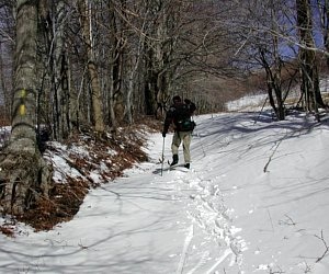
You'll walk the 'real' segment south on your way back to your car. First survey the surrounding high mountain balds. In late September, the massed militiamen found six inches of snow on the ground (the area is still known for great winter hiking and cross country skiing). On a nearby summit, "they paraded in the snow, and fired a volley in the air,' says Superintendent Carson.
Centuries after the Overmountain men's snowy September passage, the colonial trace of Yellow Mountain Road is a yellow-blazed route popular with cross country skiers.
Back to your car, don't bear right to the shelter, go straight, down the meadow in the now gentle roadbed of Bright's Trace. At the bottom, turn right along a stream to the parking area.
Over the Mountain: East Tennessee
Back on 19-E, head north and turn left with 19-E toward Tennessee.
(Tip: You're close to Banner Elk and the Boone, NC resort area with great hiking, attractions, lodging and dining, Grandfather Mountain and a scenic stretch of the Blue Ridge Parkway. Boone's Horn in the West outdoor drama depicts the story the Overmountain Men and Daniel Boone's exploration of the area.)
Enter Tennessee where the AT crosses the road, turn left on TN 143, and you're on the route of the marchers.
The massive ridge above is the Roan Highlands'where you may have just hiked to Yellow Mountain Gap. Drive another mile on this road, and after a sharp curve, look right to catch a rock overhang and a plaque on the roadside. This is Shelving Rock, credited with keeping the patriots' gunpowder dry in a torrential rainstorm. While it poured rain 'down here,' it poured snow on the heights. The powder was obtained from Mary Patton, owner of a powder works in nearby Elizabethton, TN.
Over the years, road building has eaten away at Shelving Rock. The open field across the road was the campsite on September 26, 1780. It's on the National Register of Historic Places but remains in private ownership.
Go a few miles more on TN 143 and hike to another piece of the original Overmountain route. Past Shelving Rock, turn left on Hampton Creek Road and park in Tennessee's Hampton Creek Cove State Natural Area. The parking area trail also rises to Yellow Mountain Gap, part of that seven miles of colonial road.
(Tip: Roan Mountain State Park is just a little farther and a great stop (camping, nice cabins). The road rises dramatically beyond to Carvers Gap, a must-see spot where the AT offers great hiking on open balds and a US Forest Service side road reaches the rhododendron gardens on Roan Mountain. If Carvers Gap is a prime point of interest, hike to Yellow Mountain Gap from here instead of Roaring Creek).
On to Elizabethton
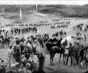
Sycamore Shoals, 1780. Visit this Tennessee Historic Park to see where the patriots forded the Watauga River. Credit: Lloyd Branson's "Gathering of Overmountain Men at Sycamore Shoals," published in the United States before 1923 and public domain in the US.
Elizabethton could be your last stop'I-81 is a fast route back home. Don't miss a must-see covered bridge, but the Overmountain landmark is Sycamore Shoals State Historic Area, a shallowing of the Watauga River where mountaineers gathered to meet a column from Abingdon, VA to the north (another spot to end your tour).
On September 25, 1780, more than 1,100 Overmountain men assembled at the Sycamore Shoals muster site to hear fiery preacher Samuel Doak inspire the patriots to use 'the sword of the Lord and of Gideon' (Judges 7:20) to defend their homeland.
Sycamore Shoals is the only National Historic Landmark on the OVHT, and the site of other historic events, including important battles and treaties with the Cherokee. Reconstructed Fort Watauga reflects archeology at the site. In the fall, a longtime annual event finds local 8th graders actually crossing the river where the patriots started out on the trail for King's Mountain.
The Bigger Picture
Whether you take these trails on Memorial Day or when reenactors gather at the battle sites on the fall anniversary dates'here are a few points to ponder from the OVHT's 2011 interpretive plan.
These marchers were also called 'Back Water Men,' because they'd defied British rules by moving ever farther into the mountains for more land and autonomy. When threatened, their "determined" march to defeat the loyalists was a 'reaction (loyalist commander) Ferguson had not anticipated.'
On the trail and in their daily lives, these backcountry pioneers 'demonstrated uniquely American attitudes, organizational approaches, and fighting styles derived from their experiences on the Appalachian frontier.'
As you walk in the militiamen's footsteps on antique sections of this trail, keep in mind, the grandest, wildest virgin forests of Eastern America's temperate rainforest still towered over the Overmountain Men. As they marched down out of vast mountains in September snow, they surely realized that even these forests and rugged summits could no longer protect them. The time had come to fight.
For more information: The idea for this trail arose in 1975 before the Bicentennial as citizens saw the value of a trail commemoration. President Jimmy Carter authorized the OVNHT in 1980. Visit the Overmountain Victory Trail Association for addition information on the trail, annual reenactments, and much more.
Story Categories:
A copy of National Parks Traveler's financial statements may be obtained by sending a stamped, self-addressed envelope to: National Parks Traveler, P.O. Box 980452, Park City, Utah 84098. National Parks Traveler was formed in the state of Utah for the purpose of informing and educating about national parks and protected areas.
Residents of the following states may obtain a copy of our financial and additional information as stated below:
- Florida: A COPY OF THE OFFICIAL REGISTRATION AND FINANCIAL INFORMATION FOR NATIONAL PARKS TRAVELER, (REGISTRATION NO. CH 51659), MAY BE OBTAINED FROM THE DIVISION OF CONSUMER SERVICES BY CALLING 800-435-7352 OR VISITING THEIR WEBSITE. REGISTRATION DOES NOT IMPLY ENDORSEMENT, APPROVAL, OR RECOMMENDATION BY THE STATE.
- Georgia: A full and fair description of the programs and financial statement summary of National Parks Traveler is available upon request at the office and phone number indicated above.
- Maryland: Documents and information submitted under the Maryland Solicitations Act are also available, for the cost of postage and copies, from the Secretary of State, State House, Annapolis, MD 21401 (410-974-5534).
- North Carolina: Financial information about this organization and a copy of its license are available from the State Solicitation Licensing Branch at 888-830-4989 or 919-807-2214. The license is not an endorsement by the State.
- Pennsylvania: The official registration and financial information of National Parks Traveler may be obtained from the Pennsylvania Department of State by calling 800-732-0999. Registration does not imply endorsement.
- Virginia: Financial statements are available from the Virginia Department of Agriculture and Consumer Services, 102 Governor Street, Richmond, Virginia 23219.
- Washington: National Parks Traveler is registered with Washington State’s Charities Program as required by law and additional information is available by calling 800-332-4483 or visiting www.sos.wa.gov/charities, or on file at Charities Division, Office of the Secretary of State, State of Washington, Olympia, WA 98504.
Comments
Mr. Johnson: This is a very interesting article about a historical and scenic pathway that led to our independence from England. I think I will go and see it!
Some friends and I were on the OVNHT in the Paddy's Creek Area ofLake James State Park and came upon some stonework/rock piles that looked like bunker/fence possibilities. Can anyone enlighten us as to what this is? Thanks