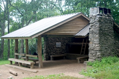
Reach Spence Field and you can enjoy lunch at the A.T. Shelter there. The Anthony Creek Trail follows the Bote Mountain Trail for a short distance. Kurt Repanshek photos.
As with so many of the footpaths in Great Smoky Mountains National Park, the Anthony Creek Trail doesn’t hesitate much before pulling you up into that landscape.
From the trailhead at the eastern end of the Cades Cove Campground, the path follows a scraggly, dirt-and-gravel single track, one that quickly loses its gravel for dirt and forest duff and its bottomlands flatness for an uphill gradient that seems to grow steeper with nearly every step. Crossing a footbridge spanning Anthony Creek, a thin stream studded with boulders and pools likely to harbor brook trout in late summer but a raging torrent during spring runoff, the trail starts modestly with gentle rises and falls as it follows the bounding stream into one of the oldest mountain ranges in North America.
In mid-summer when the temperatures can quickly rise into 90s, the moisture translates into humidity; thick, enveloping, suffocating humidity that can be an ever-present nuisance. With each upward step the sogginess under your armpits, across your back, and along your brow grows. It can be cooling, even soothing, during those too few times when a breeze stirs deep within the forest on a hot summer day. But more often than not the sweat only soaks you and serves as a dinner bell for deer flies, horse flies, mosquitoes, gnats, black flies, and other biting bugs that swarm relentlessly.
Were it not for trails, you likely wouldn’t move through this landscape at all. Two types of rhododendron (Catawba and rosebay), magnolia, three types of ferns, nine of trillium, holly, and mountain laurel and thousands of other plant and wildflower species conspire against you by forming a thick, leafy tangle of undergrowth. So thick and impenetrable can these thickets be that the Smokies' white settlers early on referred to them as “laurel slicks” and “hells,” and even questioned whether a dog could bore through the vegetation after a rabbit. The vegetative snarls can be claustrophobic, confining, and confusing.
Though sticking to a trail is definitely a much easier strategy for negotiating the Smokies, even that can be taxing. Those following the Anthony Creek Trail learn that just beyond the junction with the Russell Field Trail, as the path gets more serious, more vigorous, in its bid to climb to the park's rumpled roof. Turning left and right, and then left and right again and again, the trail slowly courses up the mountains’ flanks, conquering them in a lazy series of switchbacks that crisscross the drainage while whittling away at the elevation.
On your way up, if your lungs, heart, and legs are not demanding too much of your attention, you’ll notice the Smokies’ changing forests. From the pine-and-oak stands in the lowest elevations of the park you head up through the hemlock forests, into the Cove hardwood, and then on through the Northern hardwood forest before breaking into the spruce-fir ecosystem, a misplaced ecosystem that wound up here at the roof of the Smokies about 10,000 years ago when the Wisconsin Ice Age surrendered to climate change and retreated, leaving in the highest, and coolest, of the Smokies’ elevations many plant and tree species that today are more commonly found hundreds of miles to the north.
The Anthony Creek Trail, which joins the Bote Mountain Trail 1.7 miles below the ridgetop, terminates in a grassy bald that long ago lost its trees to a farmer who punched a hole in the forest to create pastures for his sheep and cattle. Popping out of the forest and onto Spence Field, as this bald is called, is akin to stepping out of an elevator onto the rooftop of a building. Gone is the claustrophobic enclosure of the forest. In its place the openness is capped only by the sky and any clouds overhead and the trees on the fringe.
Known early on as Spence Cabin, for a tiny, rough-hewn log cabin used by the sheep and cattle herders as well as hunters, the bald was cleared in the 1830s by James Robert Spence for his cattle. Initially the bald sprawled over 100 rumpled acres. Today, covering perhaps a third of its original open space, Spence Field is surrounded by tight knots of undergrowth and gradually is being overcome by groves of trees. From this clearing in all directions are mountains – rounded humps with heavily treed slopes and saddles, some poked with more grassy balds, others defined by heath balds knit together by blueberry and huckleberry bushes, the ever-present rhododendron and mountain laurel, by flame azaleas that in summer turn showy with their clusters of red, orange and yellow flower bursts.
Thunderhead Mountain, rising 6,527 feet above the Atlantic Ocean to stand as one of the park’s sky scrapers, looms maybe 2 miles off to the northeast, while Mount Squires, a slightly more modest 5,070 feet, can be spotted off to the southwest. Tying them together is the Appalachian Trail, a path that meanders from northern Maine to Georgia and which takes its travelers in search of both nature and themselves.
On its way north and south the Appalachian Trail splits Spence Field, its presence noted by a deep, obviously well-traveled path running northeast and southwest as well as by a small, three-sided shelter found a short jog down a spur trail that darts to the east of the A.T.
On either side of these mountains, which here are neatly split in half by the Tennessee-North Carolina border, the trees shelter gardens. Not humanly cultivated, these gardens in spring and summer are awash in a rainbow of wildflowers. Pink geraniums, purple crested iris, yellow lady slippers, pink-flowering rhododendrons and sprays of yellow coreopsis and red bee balm erupt from the rich, moist soils. Christmas and Wood ferns, holly, Fraser Magnolia, Fringed Phacelia, basswood, both White and Painted trillium, Dutchman’s breeches, a strange lily called Turk’s Cap, and Flame azalea all grow here in a wondrous array that would make a master gardener glow.
Trail: Anthony Creek Trail
Trailhead: Cades Cove
Length: 1.6 miles to spur with Russell Field Trail; 3.5 miles to junction with Bote Mountain Trail; 1.7 miles to Spence Field. 5.2 miles one-way; 10.4 miles roundtrip.
Difficulty: Moderate due to gain of roughly 3,115 feet.
Payoff: In early summer, nice floral displays, leaping brooks. Great views from the backbone of Great Smoky Mountains any time.
Resources: National Geographic Trails Illustrated map 229, Great Smoky Mountains National Park.
Story Categories:
A copy of National Parks Traveler's financial statements may be obtained by sending a stamped, self-addressed envelope to: National Parks Traveler, P.O. Box 980452, Park City, Utah 84098. National Parks Traveler was formed in the state of Utah for the purpose of informing and educating about national parks and protected areas.
Residents of the following states may obtain a copy of our financial and additional information as stated below:
- Florida: A COPY OF THE OFFICIAL REGISTRATION AND FINANCIAL INFORMATION FOR NATIONAL PARKS TRAVELER, (REGISTRATION NO. CH 51659), MAY BE OBTAINED FROM THE DIVISION OF CONSUMER SERVICES BY CALLING 800-435-7352 OR VISITING THEIR WEBSITE. REGISTRATION DOES NOT IMPLY ENDORSEMENT, APPROVAL, OR RECOMMENDATION BY THE STATE.
- Georgia: A full and fair description of the programs and financial statement summary of National Parks Traveler is available upon request at the office and phone number indicated above.
- Maryland: Documents and information submitted under the Maryland Solicitations Act are also available, for the cost of postage and copies, from the Secretary of State, State House, Annapolis, MD 21401 (410-974-5534).
- North Carolina: Financial information about this organization and a copy of its license are available from the State Solicitation Licensing Branch at 888-830-4989 or 919-807-2214. The license is not an endorsement by the State.
- Pennsylvania: The official registration and financial information of National Parks Traveler may be obtained from the Pennsylvania Department of State by calling 800-732-0999. Registration does not imply endorsement.
- Virginia: Financial statements are available from the Virginia Department of Agriculture and Consumer Services, 102 Governor Street, Richmond, Virginia 23219.
- Washington: National Parks Traveler is registered with Washington State’s Charities Program as required by law and additional information is available by calling 800-332-4483 or visiting www.sos.wa.gov/charities, or on file at Charities Division, Office of the Secretary of State, State of Washington, Olympia, WA 98504.

Comments
Some 20 years ago I took my 14 year-old daughter and her friend for what I had remembered as a leisurely climb to Rocky Top and Thunderhead. My middle-aged body was worn to a frazzle by the time we returned to Cades Cove after an "epic hike". Yes, it's a beautiful and demanding hike, but not for the faint of heart. At that time much of the trail was strewn with large rocks and had been battered and littered by horsemen. I hope that the trail remains natural, but is better maintained.
Ten years later I made the same trip alone after convincing myself that "a man's gotta do what a man's gotta do". I only made it as far as Rocky Top on this return trip, but it was worth it to get away from the stifling heat and humidity of Charleston and to enjoy one of the great Smokey Mountain trails.
Kurt - great write-up. This is probably one of the most underrated hikes in the park, and one of my most favorites. If hikers still have the energy after arriving at Spence, continue walking eastward along the Appalachian Trail for another 1.2 miles to reach Rocky Top - the first "peak" on Thunderhead Mountain. The views up there are some of the best in the Park.
Jeff
The last time I visited Spence Field, I lay in the grass while my hiking buddies went on up Rocky Top, a crest just shy of Thunderhead. So very refreshing. During the fall, when views tend to be best, expect many busy bees wishing to share or at least investigate your lunch.
Those without the legs for this climb can go by horseback on the described and other trails, but I wish they wouldn't. Added interest can be had by going west on the AT to Russell Field and back down to rejoin the Anthony Creek trail near its bottom.
Great hike. Something of note is that Spence Field is the site of one of the more well known cases of a dissapeared person in the park. A young boy hiking with his family in 1969 at Spence Field ducked around some brush in an attempt to sneak up behind his parents and scare them. That was the last time he was ever seen. What followed was one of the largest manhunts ever to happen. Over a thousand searchers covered almost 60 square miles of territory in the following weeks. Absolutely no trace of him was ever found. It's hard not to hike up there and not wonder what happened that day.
I first hiked in the Appalachians in August of 1969. I was 11 years old and our Scout Troop was on a 70 mile journey that started at Davenport Gap and ended at Fontana Dam. I remember Spence Field very well. We camped there that one night and I recall the openess and great views of Fontana Lake way in the distance. It was a very special place, although I don't recall at the time if I knew that 2 months earlier a young boy forever vanished. In Septemer 2011, over 42 years later, I hiked back to Spence Field hoping to catch those great views and uniqueness that the grassy bald offered in that thick forest of the Appalachians. I quickly saw the grassy bald had greatly shrinked and along with that no views of Fontana Lake in the distance. Young serviceberry trees had overtaken the bald for the most part. Nonetheless, we had lunch there and it gave me an opportunity to reflect on those precious memories while realizing that time most definitely brings about change.
we hiked out of the Appalachian trail feom clibgmans dome and hiked 1.7 on the bote trail and then turned right and hiked 3.5 miles on Anthony creek trail. We heard there as parking near that junction so we could go back and just hike 1.7 to the AT To finish our hike to Fontana dam Anyone know where that is?