Curious about Glacier Bay's glaciers? The following paper was written for the National Park Service by Dr. Daniel E. Lawson of the Cold Regions Research and Engineering Laboratory in Hanover, New Hampshire, in 2004. It provides a good primer on the park's tidewater and terrestrial glaciers.

Introduction
In general, tidewater and terrestrial glaciers in the park have been thinning and slowly receding over the last several decades. Reduced snowfall in their ice-field sources and warmer temperatures during winter, coupled with an apparent reduction in cloud cover and precipitation during the summer, are the probable causes of this trend. Johns Hopkins Glacier is currently the only advancing tidewater glacier on the eastern side of the Fairweather Range, while the LaPerouse Glacier draining from the western side of the Fairweather Range continues to have a relatively stable tidewater margin, being the only glacier in North America that calves periodically directly into the Pacific Ocean. In addition glaciers within Lituya Bay continue to show advance.
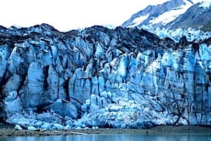
Johns Hopkins Glacier continues to advance with Gilman Glacier as a single ice front. The glacier is about 1-mile (1.6 km) wide, 250 feet (76 m) high at the terminus, and 200 feet (61 m) deep at the water line. It is formed from numerous tributary glaciers, many of which extend 12 or more miles (19+ km) into the surrounding peaks. About 50 medial moraines develop from the joining of these tributary glaciers. The debris in these moraines can be seen in the ice face and extending up-glacier as prominent black bands.
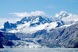
Johns Hopkins Glacier, Kurt Repanshek photo.
This debris is transported in and on the ice and released either by melting of the ice face or calving of icebergs into Johns Hopkins Inlet. Melt-water from the glacier is discharged from submarine tunnels or conduits located near both the eastern and western edges of the glacier. Sometimes this water emerges at the inlet surface as fountains. Birds are commonly seen diving and floating where the meltwater upwells along the ice face.
The glacier flows down the main valley at about 3,000 feet per year, or about 8 feet per day, according to observations made in the late 1970s by S. Brown and others. Ice flow rates have not been measured recently. However, Field, Post, Brown, Lawson and others have observed rapid calving and continued ice advance, which suggests little change in flow has occurred since Johns Hopkins began advancing in 1924, about the same time that Grand Pacific Glacier began advancing into Tarr Inlet. Ice flow and terminus advance rates appear to have fluctuated over the last several or more years. Johns Hopkins joined Gilman Glacier at its eastern edge in about 1990. During the decade following this merging of the ice, the two glaciers have separated and joined several times. The two glaciers were once again attached at the eastern edge of Johns Hopkins in 2000 and both are now advancing slowly with a 150 to 200 foot steep ice face where they join.
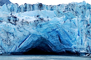
Of note, Johns Hopkins is characterized by submarine calving -calving below the water surface caused by breaking off of ice from an “ice foot” that extends from the basal part of the glacier. These “basal bergs” rise suddenly and unexpectedly, emerging, sometimes explosively, without warning at the water surface. In late July 2003, submarine calving was extremely active.
Grand Pacific Glacier is about 2 miles (3.2 km) wide at the terminus, averages about 150 feet (45.7 m) high at the ice face, up to 60 feet (18.3 m) deep at the waterline and over 35 miles (56.3 km) long. Much of the ice margin is now grounded at low tide; the calving section probably reaches a water depth of only 30 to 60 feet (9.1 - 18.3 m). The ice cliff is estimated to be 60 feet (18.3 m) high where it is grounded, but about 150 feet (45.7 m) and up to 180 feet (54.9 m) high where it calves into Tarr Inlet. Behind the terminus, the ice may thicken to 900 feet (274 m) or more. The western two thirds of the ice in the terminus of the Grand Pacific Glacier originate from the tributary Ferris Glacier, and flows about 1,500 feet (457 m) per year or about 4 feet (1.2 m) per day. This latter estimate is based on measurements of aerial photographs taken between 1988 and 1990 and may be higher than current rates based on the fact that the ice has been thinning over the last 7 years or so.
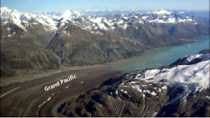
Grand Pacific Glacier, NPS/CRREL photo.
The eastern portion of Grand Pacific Glacier moves only about 150 to 180 feet (45.7 - 54.9 m) per year based on GPS measurements made by CRREL in 1998-1999. It had advanced at a rate of about 60 feet (18.3 m) per year for the last several decades, but it reached a maximum position when it joined Margerie Glacier around 1992. These glaciers are no longer together due to recession of the Grand Pacific margin. A small stream presently flows between the two termini.
The eastern edge is currently receding at about 30 to 60 feet (9.1 - 18.3 m) per year and shows significant thinning and closure of crevasses. In about 1996, an embayment began to form in the center of Grand Pacific’s terminus. Since then, the center of the ice cliff has begun to calve more rapidly and is slowly receding at perhaps 30 feet (9.1 km) or less per year. We anticipate that retreat will accelerate as the embayment enlarges and the depth at the waterline increases. In such a scenario, retreat is likely to continue until the terminus reaches a position where it will become grounded above mean tide. The grounded western edge of the glacier is also slowing receding (10 to 30 feet / 3-9.1 km per yr) and thinning. Rock debris from landslides and medial moraines cover much of this side of the glacier and extends across almost two-thirds of the ice face. Where this rock debris is more than an inch thick, it insulates the ice, slows melting and results in a thicker ice mass than where the ice is clean. In many areas on the glacier, the debris is more than 3 feet (0.9 m) thick.
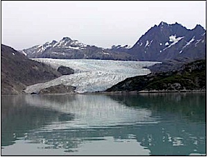
Lamplugh Glacier is about ¾ mile wide, 150 to 160 feet high at the face, 10 to 40 feet deep at the waterline, and over 16 miles long. The glacier heads in the Brady Icefield, which lies east of the Fairweather Range. Ice flow rates have not been measured but are estimated at 900 to 1000 feet per year. The margin is currently receding by calving in the central and eastern part of the ice face at variable rates we estimate to be around 50 to 100 feet per year.
Lamplugh Glacier, Kurt Repanshek photo.
The western third or so of the terminus is grounded, and only at the highest high tides does saltwater reach all but the far western-most edge of the ice face. A large subglacial stream flows from the central part of the terminus, but its position shifts laterally from year to year, sometimes in response to build-up of fluvial sediment as a small delta that can be seen at low tide. Such subglacial streams discharge large volumes of sediment-rich water into the fjord, filling the small embayment at the ice edge with brown to tan milky water.
Margerie Glacier is about 1-mile wide, with an ice face that is about 250 feet high above the waterline, but with its base about 100 feet below sea level. The glacier is about 21 miles long and extends into snow-fields in the Fairweather Range where elevations exceed 9000 feet. The ice flows about 2000 feet per year, or about 6 feet per day. It has been advancing about 30 feet per year for the past couple of decades. Margerie Glacier joined Grand Pacific Glacier about 1990, but they have since separated as Grand Pacific recedes.
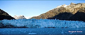
Margerie Glacier, NPS/CRREL photo.
Margerie Glacier is a hanging glacier with its base about 600 feet above the floor of Tarr Inlet near its center. Margerie’s terminus was relatively stable in position through the 90’s; however, about 1998 the northern third of the terminus began a slight recession, forming a small embayment within the ice face. Over the last 3 years, this part of the terminus has thinned and the embayment has expanded. In contrast, the southern half of the margin
appears to be slowly (feet per year) advancing. The northern most part of the ice is grounded on morainal materials where it is separated from Grand Pacific Glacier by a small lateral stream. Most meltwater discharges from subglacial streams below the water surface within the central area of the glacier; upwellings and occasionally fountains, locate where the water emerges at the ocean surface. Seabirds commonly feed in these freshwater upwellings.
McBride Glacier is about ½ mile wide and 14 miles long. Its ice face is approximately 200 feet high above the waterline and currently extends about 270 feet below it. Ice flow rates have not been measured, but are estimated to be on the order of 3000 feet per year. McBride Glacier has been steadily thinning and retreating by calving since the 1960s after its separation from Muir Glacier. Submarine moraines mark several positions in McBride Inlet where the ice mar-gin was stable in position for several or more years. Over the last 5 years, retreat rates have increased to about 200 to 300 feet per year, with occasional massive calving events releasing enough large icebergs to fill all of McBride Inlet.
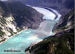
McBride Glacier, NPS/CRREL photo.
The rate of retreat accelerated as the ice margin receded from water with depths of 60 feet at the edge of the ice face and a proglacial basin of around 120 to 140 feet depth in 1999, into a deeper basin where depths were measured to be around 250 feet or deeper. In the summer of 2003, a significant amount of calving had occurred, more so than in the previous two years. A significant portion of the northern half of the ice margin had receded ~ 85 meters in less than an estimated 7 day period. With deep water at its margin, McBride Glacier is expected to continue receding at a fairly rapid pace. We are mapping the ice position and water depth near the glacier as well as conducting annual photo surveys from known points to keep track of the activity.
Muir Glacier is ½ mile wide, 150 feet high and about 13 miles long. This glacier is no longer tidewater. Two large deltas currently fed by subglacial streams emerging at the eastern and western edges of the glacier coalesced in about 1996 and now extend over 1400 feet to water’s edge at low tide. During its catastrophic retreat that began in 1899, flow and calving rates were extreme.
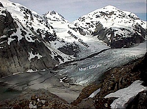
Muir Glacier, NPS/CRREL photo.
Muir Glacier flowed at about 6,000 feet per year, or about 16 feet per day as late as 1979. Today, ice flow near the terminus is about 150 feet per year, or 0.5 feet per day based on GPS measurements by CRREL between 1998 and 2001. The continual retreat of the glacier from the mouth of Muir Inlet produced the transition of the glacier from one that was tidewater with a submarine grounding line to one that became terrestrial in 1993. The terminus position is relatively stable at this time; however, the ice is progressively thinning and surface crevasses that characterize tidewater glaciers are generally no longer pre-sent in the terminus region.
The large mounds of sediment that parallel the ice margin are formed during winter when ice melt rates are much lower and ice advances seasonally, carrying and shoving deltaic sediments ahead of it. Thus the mounds are actually ice-cored, and with slow ice flow in summer and melting, sediments are gradually shed from them, exposing the ice and allowing it to melt. The tributary glacier, Morse Glacier, has been thinning more rapidly than Muir. A medial moraine marks where the edges of the two glaciers join. Where the western lateral stream emerges as a tunnel from beneath the Morse tributary, the ice has been collapsing, and it is common to see blocks of glacier ice in the streambed and on the delta in front of the glacier as a result.
If thinning continues and ice flow remains fairly slow, the Muir Glacier margin may begin to retreat. Ground-penetrating radar (GPR) analyses by CRREL in 1996 revealed that Muir Glacier thickens rapidly up-glacier, exceeding 450 feet in thickness and 300 feet below sea level approximately 1500 feet be-hind the ice margin. Thus, if the glacier retreats faster than the basin that is exposed by ice recession is filled with sediment discharged from glacial streams, the ice may again calve into Muir Inlet.
Reid Glacier, Kurt Repanshek photo.
Reid Glacier is about ¾ mile wide, 150 feet high, 10 to 30 feet deep at the waterline and over 10 miles long. Like Lamplugh Glacier to the west, it originates in the Brady Icefield. Ice flow rates have not been measured but are estimated at 15 feet per day. Both the eastern third and western third of the glacier is now grounded and basically terrestrial. Only the central area with its deep blue ice is affected by high tides when calving may occur. Water here is about 30 feet deep next to the ice face. Sediment deposited from streams draining out of the glacier on the eastern and western margins is gradually filling the inlet in front of the glacier, the deposits being exposed at low tides. The center of the glacier continues to slowly recede at about 30 to 50 feet per year, while the remainder of the margin has been receding at about 30 feet per year or less while progressively thinning. Crevasses that characterized Reid Glacier within its terminus region since the early 1900s are slowly closing as flow rates decrease and the terminus becomes terrestrial. The glacier filled all of Reid Inlet in 1899 and has slowly receded to its current position since that time.
On the walls of the fjord, lateral deposits of the glacier extend from near the waterline up and along the bedrock face, and mark the positions and thickness of the ice at locations where it remained stable for some period of time during this overall period of recession.
Riggs Glacier is about ¾ mile wide at the terminus, 40 to 90 feet high in the ice face and about 15 miles long. The terminus became mostly terrestrial during the mid-1980s as an outwash delta built across the southern margin. Currently, tidewater only reaches the terminus during higher tides just to the left and right of the bedrock knob or nunatak in the left center of the ice face. Ice flow separates in the terminus region as it flows around this nunatak and a second ridge located further south.
Riggs Glacier, NPS/CRREL photo.
The southernmost portion of the terminus is blocked by stagnant ice that once flowed from McBride Glacier. The McBride ice is sometimes buried in the outwash near the glacier margin and melting over the last several years has caused kettles or depressions to form above the melting buried ice. Riggs Glacier has been thinning progressively over the past two decades and is expected to continue thinning and slowly receding. Ice recession has been averaging about 20 to 30 feet per year for the last 5 years.
Terrestrial Glaciers
Like the tidewater glaciers, most of the terrestrial glaciers in the Park are thinning and slowly receding. These glaciers are less commonly observed due to their inaccessibility, but we have used both overflights and satellite imagery combined with ground observations to examine their activity. Glaciers that are likely to be visited by hikers include Hugh Miller, Geikie, Topeka and Skidmore. In each case, they have undergone fairly continuous, albeit slow recession and thinning over the last 30 or more years. Rates of recession are typically 30 to 60 feet per summer, with seasonal winter advances of 30 or more feet. The ice margins today are fronted by large areas of outwash deposited by meltwaterfed, subglacial streams during the extended retreat of the last 40 or more years. In the case of Geikie Glacier, sediment discharge has been high, enough so as to bury parts of the terminus as it continues to thin and recede. The instability of Geikie can be noted in mid-summer when it appears to be literally falling apart; individual crystals of ice are released by melting along their boundaries and they fall out of steep ice faces and litter the slope at their base.
An additional glacier of interest is Carroll Glacier, which surged in June 1987, moving about 90 feet/day or 3600 feet over the course of the surge. Since the surge ended in August 1988, the ice has been slowly thinning but the margin has been relatively stable in position. Debris from the surge now covers most of the terminus near the glacier’s margin. Rendu Glacier at the head of Rendu Inlet is also a surging glacier and has a rugged, debris-covered terminus developed following its last surge about 20 years ago. Because of the debris cover, it has been very slowly thinning.
- By Kurt Repanshek - July 14th, 2025 8:05am


