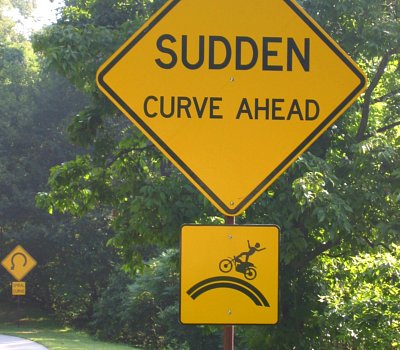
The Blue Ridge Parkway's creative use of new and compelling signs has significantly reduced accidents. What motorcyclist wants to emulate the "moto-man" sign? Even a "flatlander" could guess things will go downhill fast if you speed through a "spiral curve." NPS photos
A Blue Ridge Parkway study shows that National Park Service signing seems to be reducing the number of accidents on the high road. Bottom line—the cautions urged by the research are applicable to almost any national park you might find yourself in this summer.
The release said, “On the 10-year anniversary of initiating its traffic safety and aggressive sign program, the Parkway is pleased to report a significant reduction in motor vehicle incidents. Visitor and traffic safety on the Parkway is always of paramount concern, and in recent years strides have been made to decrease the number of traffic incidents.”
After seeing a year with 450 wrecks on the Parkway (a rate of nearly one accident per mile for the 469-mile road), the park started the research in 2001 to assess the number of crashes over a five year-period. “The study organized information about wrecks into several categories including type of vehicle, number and type of injuries, number and type of fatalities, precise dates and times, as well as locations of the incidents.”
With no offense to visitors from “off the mountain,” one of the study’s major findings reflected what local mountain residents have long known to be the bane of motorists from “the flatlands” where roads are generally straight. “The study indicated that areas with unique road features such as descending radius curves, or ‘spiral curves,’ and in some cases, overlooks, further contributed to loss of attention and distracted driving.”
Using this information, the report said a traffic safety campaign was begun to monitor and reduce wrecks in the geographic areas identified as hotspots in the study. In an effort to reduce the number of wrecks, law enforcement rangers shifted schedules to patrol those locations at times identified as high risk.
In addition, a new "aggressive sign" program was initiated to identify and place signs with symbols that accurately described and illustrated the nature of the curve and also illustrated the type of wrecks occurring in targeted areas. One of the signs is called the "moto-man" and shows a biker flying off the road. The Parkway has become an extremely popular motorcycle route and the moto man signs in particular are meant to address the high number of motorcycle wrecks the Parkway sees each year.
The first signs were installed in the Pisgah district of the Parkway at Mt. Lyn Lowery (Milepost 445.2) in August of 2002, an area that, that at the time, was experiencing an average of five wrecks a year.Since the sign installation in 2002, only 3 wrecks have occurred in that area, with only one reported injury.
Several other locations were also identified, including an area near Linville Falls, where a 3 mile section of road, was identified as a "High Collision Area" due to the number of unique curves occurring throughout that section.This area was seeing an average of 8 wrecks per year, several with fatalities. Various safety signs were installed in 2003, including "spiral curve" and "moto-man" signs. Since the signs were installed in 2003, only 11 wrecks have occurred throughout this section, and of those only three reported injuries and there have been no fatalities.
Other areas along the Parkway identified as high frequency wreck areas have also been signed and are experiencing similar reductions in incidents.
The study and successful sign program have led to a slogan apt for the Parkway but relevant for any park—Enjoy the View. Watch the Road. Those words may seem obvious but it is amazing how many motorists zip by Parkway overlooks craning to see the view—instead of simply safely pulling over and really enjoying the scenery. Or simply pulling over to let faster traffic pass instead of delaying those who later feel the need to drive faster.
Whichever park you visit—take the hint! It’s easier to enjoy the scenery when you step out of your car.
The following data dramatically illustrates the dip in accidents and demonstrates the success of the program.
Parkway Wide Motor Vehicle Wrecks
2000 / 450 +
2001 / 442
2002 / 411
2003 / 409
2004 / 361
2005 / 358
2006 / 373
2007 / 345
2008 / 253
2009 / 281
2010 / 252
2011 / 254
Story Categories:
A copy of National Parks Traveler's financial statements may be obtained by sending a stamped, self-addressed envelope to: National Parks Traveler, P.O. Box 980452, Park City, Utah 84098. National Parks Traveler was formed in the state of Utah for the purpose of informing and educating about national parks and protected areas.
Residents of the following states may obtain a copy of our financial and additional information as stated below:
- Florida: A COPY OF THE OFFICIAL REGISTRATION AND FINANCIAL INFORMATION FOR NATIONAL PARKS TRAVELER, (REGISTRATION NO. CH 51659), MAY BE OBTAINED FROM THE DIVISION OF CONSUMER SERVICES BY CALLING 800-435-7352 OR VISITING THEIR WEBSITE. REGISTRATION DOES NOT IMPLY ENDORSEMENT, APPROVAL, OR RECOMMENDATION BY THE STATE.
- Georgia: A full and fair description of the programs and financial statement summary of National Parks Traveler is available upon request at the office and phone number indicated above.
- Maryland: Documents and information submitted under the Maryland Solicitations Act are also available, for the cost of postage and copies, from the Secretary of State, State House, Annapolis, MD 21401 (410-974-5534).
- North Carolina: Financial information about this organization and a copy of its license are available from the State Solicitation Licensing Branch at 888-830-4989 or 919-807-2214. The license is not an endorsement by the State.
- Pennsylvania: The official registration and financial information of National Parks Traveler may be obtained from the Pennsylvania Department of State by calling 800-732-0999. Registration does not imply endorsement.
- Virginia: Financial statements are available from the Virginia Department of Agriculture and Consumer Services, 102 Governor Street, Richmond, Virginia 23219.
- Washington: National Parks Traveler is registered with Washington State’s Charities Program as required by law and additional information is available by calling 800-332-4483 or visiting www.sos.wa.gov/charities, or on file at Charities Division, Office of the Secretary of State, State of Washington, Olympia, WA 98504.

National parks and their natural resources belong to you. The National Parks Traveler works to ensure you know how these essential places are being cared for.
Sign Up For Our Weekly Newsletter
Unsubscribe at any time.
INN Member

The easiest way to explore RV-friendly National Park campgrounds.

Here’s the definitive guide to National Park System campgrounds where RVers can park their rigs.
Our app is packed with RVing- specific details on more than 250 campgrounds in more than 70 national parks.
You’ll also find stories about RVing in the parks, tips helpful if you’ve just recently become an RVer, and useful planning suggestions.

Comments
I recently drove from Front Royal VA to Ashville NC using the skyline drive and the Blue Ridge PKY. I realized after 10 miles on the Blue Ridge that the character of the road had changed. The Blue Ridge is more faithful to the topography of the Mountains, riding ridge backs far more than the skyline drive. Once I realized this my driving style became much more alert and focused. I think travelers need to note this different character and remember that the BR was built as a connector road between the great smokies and the skyline Dr and I suspect far less was spent on its engineering
I worked there the summer of 2004 and I was witness to several accidents, almost all involving motorcycles. There was one fatality that was due to the sharp curves. THe gentleman riding the motorcycle was in his lane, but because he was leaning into the curve, his head extended into the other lane. I'm glad to see that these signs are helping.