Gearjammer on Sun Road in Glacier, motorcycles at Park Lane in Arches, entrance station on Tioga Pass Road in Yosemite, and caribou on the Park Road in Denali. Arches photo by Bob Janiskee, bottom photo by NPS, other photos by Kurt Repanshek.
Editor's note: There is incredible scenic beauty in the National Park System, and the founders of the National Park Service were determined to show it off. They chose wisely in deciding where roads would go, utilizing landscape architects in some parks to be sure the best views were on display. In this story pulled from the Traveler archives and updated, Contributing writer Bob Janiskee takes a look at some of the wonderful "windshield touring" choices available to motorists in our national parks. Drives in the western parks are featured today. Eastern park options will be featured in part two.
We love our cars, we love our parks, and we love to drive our cars in the parks. Well, at least when the traffic isn’t too bad, and we really don’t mind just going along for the ride. The windshield touring season is nearly here, so it’s time to start thinking about scenic drives in the parks. Here are some traverses, loops, and shuttles in the western parks that we know you'll like.
GLACIER NATIONAL PARK
The main attraction of northwestern Montana’s Glacier National Park is the east-west drive across the Continental Divide on Going-to-the-Sun Road (aka Sun Road). Completed in 1932, and rated as one of the great engineering feats of its time, the Sun Road is considered by many to be the single best scenic mountain drive in the 48-state U.S.
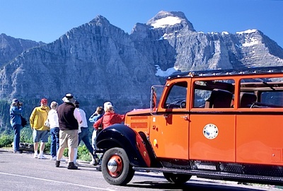
Visitors normally undertake the 50-mile drive in their private vehicles, enjoying the scenic turnouts, charismatic wildlife, wayside exhibits, and magnificent views from the road. However, the park’s little red 1930s-era “gear jammer” tour buses offer a superb way for visitors to just sit back and enjoy the trip. The park refurbished the gear jammers, which are listed on the National Register of Historic Places, and equipped them to run on clean-burning propane fuel.
Stop and walk: Stop at the Logan Pass Visitor Center, which is on the Continental Divide. You may need to wait a while for a parking spot, since the lot is often full between the hours of 9:30 am to 4:00 pm. From the parking lot, take the Hidden Lake Nature Trail, which is renowned for its gorgeous vistas and friendly mountain goats.
Caveats: Make sure your vehicle is mechanically sound , especially the brakes and cooling system. Don’t be in a hurry. The Sun Road is often congested and is intermittently closed for rehabilitation work (basically a rebuilding job) that was launched in 2007 and will take at least several more years. To avoid wasted trips or lengthy delays, motorists planning to drive the Sun Road should always check for current weather and road conditions.
This narrow and twisty road was not constructed with motor coaches and big travel trailers in mind. On the stretch from Avalanche Creek to Sun Point there is a ban on buses and all other vehicles more than 8 feet wide (including mirrors) or over 21 feet long (including bumpers).
Regardless of what you drive, don’t expect the road to be open all of the way, all of the time. Though roadwork and rock slides may be a hindrance, the main culprit is snowfall. The road can normally be kept only open from about the first week of June until early fall. (It has opened as late as June 23 and closed as early as October 4.) Intermittent closings of a day or two are a constant threat because avalanches or rock slides and fresh snowfall can happen any time of year.
YELLOWSTONE NATIONAL PARK
The Grand Loop road at Yellowstone is one of the oldest and most celebrated windshield touring routes in America. The figure eight-shaped double loop connecting the park’s main tourist attractions began to take shape as a stagecoach route in the mid-1880s, was pretty much finished by 1891, and was paved by 1934. The upper (northern) loop is no scenic slouch, but most park visitors consider the lower loop far superior because it affords the chance to see Old Faithful, West Thumb, Yellowstone Lake, Shoshone Point, the Hayden Valley, and the Yellowstone River as well as the elk, bison, moose, bears, wolves, and other charismatic species inhabiting “America’s Serengeti.”
Stop and walk: You can go bonkers trying to pick and choose among the many stop-and-take-a-lingering-look attractions on the Grand Loop. Allow plenty of time for just strolling and looking. Be sure to stop at Old Faithful, the park’s icon landmark. And by all means take the spur road to Artist Point, walk to the overlook, and enjoy a never to be forgotten view of the Grand Canyon of the Yellowstone and Lower Falls. Few vistas in the entire Park System are as drop-dead gorgeous as this one.
Caveats: Road construction and foul weather cause intermittent and seasonal closures and delays. Before leaving for the park call the 24-hour Current Road Report hotline at 307-344-2117 to check road conditions. All roads south through the park, including the road to Old Faithful Geyser, are closed to wheeled vehicles from early November through late April. Be mindful of wildlife as you drive. In a typical year, vehicle collisions kill more than 100 large animals, including bears, elk, bison, deer, moose, and wolves. Vehicle-animal collisions sometimes injure or kill motorists too, and if a car hits one of the larger animals it may be totaled. An elk can be nearly as big as a horse, and a male bison, moose, or grizzly can weigh nearly as much as a compact car.
ROCKY MOUNTAIN NATIONAL PARK
Glacially sculpted mountains, lowland meadows, subalpine forests, alpine tundra, and watchable wildlife draw some three million visitors a year to this Colorado jewel. Most enter and depart via Trail Ridge Road (U.S. 34), which stretches 48 curvy miles between Estes Park on the east and Grand Lake on the west. Rocky Mountain is too high and cold to have the wildlife diversity of Yellowstone, but the park is noted for wildlife viewing and offers windshield tourists good opportunities to see charismatic megafauna such as mule deer, elk, bighorn sheep, and the odd black bear, moose, or mountain lion.
Topping out at 12,183 feet, Trail Ridge Road stands alone as the Park System’s
high-altitude champion. None of the other 393 units in the system has a continuously paved road that reaches a higher elevation. A special feature of Trail Ridge Road is the windswept 11-mile stretch that lies above the treeline. Though it’s cool and breezy up there in the summer, a fact that draws many a heat-weary tourist, it gets very windy and cold in the winter.
Stop and walk: The Tundra World Nature Trail, which begins near the parking area at Rock Cut, is an easy half- hour walk that features colorful tundra flowers and lots of wildlife. Also stop at the Alpine Visitor Center (elev. 11,796 feet), which is located about two miles north of the highest point on Trail Ridge. A short trail from the parking lot there leads to a high vantage point for panoramic photo ops.
Caveats: Because Rocky Mountain is so easily accessible from Denver and Boulder, Trail Ridge has a good deal of traffic congestion at the summer peak and during the fall elk bugling season. Snow closes the road from late fall to early summer, so don’t go there then. When you do go, make sure your vehicle is up to the job. The grade is not dramatically steep – nowhere more than 7 degrees -- but the long climbs and lower barometric pressure work a hardship on underpowered engines and inadequate cooling systems.
There is significantly less oxygen in the air at this altitude, too, and that can trigger health problems. Mild oxygen deficiency may be only an annoyance for healthy people, but it’s potentially lethal for people who are sick or frail. This trip is most emphatically not recommended for people with serious heart or respiratory problems.
COLORADO NATIONAL MONUMENT
Any motorist or bicyclist who has experienced Rim Rock Drive in Colorado National Monument will tell you that the sheer-walled redrock canyons, towering monoliths and soaring arches of this dissected sandstone plateau are almost indescribably beautiful. Bighorn sheep, soaring eagles, and other charismatic wildlife are a delightful bonus.
Stop and walk: Rim Rock Drive offers access to the Saddlehorn Visitor Center and campground, 19 signed viewpoints, and 14 hiking trails, including some short, easy ones.
Caveats: Allow at least an hour for the drive, and for goodness sakes, don't be in a hurry. There's a reason for the low speed limits on this 23 mile-long road. Rim Rock drive is a challenging route with sections that are narrow, steep, and twisty. Tunnels, falling rocks, tight corners, narrow shoulders, and dismayingly sheer dropoffs all beg caution. Passenger vehicles share the road with bicycles (of which there are often plenty), and may even encounter large trucks in the four-mile stretch of the route that provides access to the Glade Park community on the eastern side of the park.
ARCHES NATIONAL PARK
Arches National Park near Moab, Utah, preserves a fantastic collection of natural sandstone arches produced by millions of years of erosion. Numbering more than 2,000 in all, and including the world-famous Delicate Arch, this is the densest concentration of these unusual rock formations existing anywhere on Earth. The park’s scenic drive, with its handful of spur roads, makes it easy for windshield tourists to enjoy very special photo ops and memory-moments. Plan to spend the whole day if you want to drive the length of the scenic road and make forays up the spurs to attractions and viewpoints.
Stop and walk: If you’ve got three or four hours at Arches, you can do all three of the primary stop-and-walks. The first is a stroll beneath the Window Section’s North Window or Double Arch. It’s a great opportunity to get up close and personal with the arches. Then drive up to the parking lot at the Delicate Arch Viewpoint and walk the short trail to the viewpoint, which is positioned about a mile from the picturesque arch. Don’t forget to bring your camera! Finally, stop and have a look at the post-Civil War era Wolfe Ranch on your way back to the main road. If you have the time, skip the Delicate Arch viewpoint and instead make the 3-mile roundtrip hike to stand in the arch’s shadow.
Caveat: Arches National Park has some resource damage issues associated with the park’s increased popularity. Designated parking spaces are often hard to find at the most popular sites, so people have begun to park in areas where they shouldn’t. To spare roadside vegetation and soil, and to reduce the risk of dangerous accidents, park only in established lots. Parking spaces are generally easiest to find before 9:00 a.m. and after 7:00 p.m.
SEQUOIA AND KINGS CANYON NATIONAL PARKS
These two “partner” parks in the rugged southern Sierra Nevada Mountains extend from the foothills to the wilderness High Sierra. Giant sequioas, rugged mountains, and deep canyons are the main draw. Linking up these and other attractions (including large caverns) are two remarkable scenic routes – the Generals Highway in Sequoia National Park, and California State Highway 180 in Kings Canyon National Park. One route blends almost seamlessly into the other, yielding a scenic byway of considerable length and diversity.
A drive that few windshield tourists can ever forget begins at the Foothills Visitor Center (elev. 1,700 feet), proceeds upward on the Generals Highway, switches to Highway 180, transitions to the Kings Canyon Scenic Byway, and ends where the road quite literally terminates and nothing lies beyond but mile after mile of mountain wilderness.
Stop and walk: The pride of the Generals Highway is the General Sherman sequoia tree in Giant Forest. It is the largest living tree on earth, and to see this giant and its huge neighbors you need to take a short hike from the parking lot. Further up the mountain on 180 you’ll want to visit the General Grant Grove and see the giant sequoia for which this grove is named. Even further up 180, where the awe-inspiring Kings Canyon dominates the scenery, there are a number of scenic overlooks that are great for biding a while. If you drive to the wilderness terminus of 180, there are several trails to try.
Caveats: Get current road and weather info before you leave for the park. Fill your tank up too, since no gas is sold in the parks. Remember that the onset of winter forces seasonal closing of the roads. And if anyone in your windshield touring party has a bad time on roads with sharp curves, steep grades, and sheer cliffs next to the roadway, you might want to think twice about driving 180 down into and back out of Kings Canyon. The highway is excellent, but stretches of that route rate around 8.0 on the white knuckle scale for a lot of people.
YOSEMITE NATIONAL PARK
The only road that crosses Yosemite in the east-west direction is the Tioga Pass Road (SR 120). Accessible from the Central Valley, this 39-mile long trans-Sierra route begins at Crane Flat and ascends the west flank of the Sierras, gaining more than a mile in elevation before reaching the park’s eastern entrance at Tioga Pass.
This is true mountain terrain. The Tioga Pass Road is the loftiest automobile highway in all of California, and the Tioga Pass entrance that anchors its eastern end is the loftiest park entrance (elev. 9,945 feet) in the entire world. The Tioga Pass Road earned California Historic Civil Engineering Landmark designation as the most scenic mountain road in California. Some who have toured the Sequoia & Kings Canyon National Parks roads may disagree with that, but the Tioga Pass Road certainly offers windshield tourists memorable views of lush evergreen forests, shimmering lakes, glacial valleys, and wildflower-covered meadows. This route’s familiar “T signs” are a trademark feature.
Stop and walk: Stop at the Tuolumne Meadows Visitor Center and try one of the hiking trails that radiate into the high country.
Caveats: The Tioga Pass entrance is closed from the first big snowfall in the fall until the last big snowfall in late spring or early summer. The average opening date is May 29 and the average closing date is November 1. Regardless of the time you travel, remember that this road has some pretty impressive grades and curves. Make sure that your vehicle is up to the task.
DENALI NATIONAL PARK & PRESERVE
Alaska’s Denali National Park & Preserve doesn’t just offer mountain, boreal forest, and tundra scenery that is gorgeous beyond description. It also competes with Yellowstone for the title of America’s premier wildlife park. Denali has just one public road, but it extends fully 90 miles into the interior. The first 15 miles of the Park Road are paved, and the rest is gravel-surfaced. With the exception of inholders and their guests, motorists can operate private vehicles only as far as Mile 14. Beyond that point, tourists must walk, ride bicycles, or use the bus service. The bus service is by far the most popular choice. A fleet of several dozen concessionaire-operated buses takes visitors into the park from mid-June to mid-September.
Riding the buses affords windshield tourists the opportunity to view wilderness boreal forest and tundra landscapes complete with Alaska's "Big Five" -- grizzly bears, wolves, moose, caribou, and Dall sheep. On the rare clear days they can even see Mt. McKinley (known to locals as Denali), North America’s highest peak
In September, when the prime tourist season is over, locals who are lucky enough to get a permit (distributed by lottery) can drive their vehicles the full length of the park road and enjoy the fall colors. After the fall color season, motorists may use a specified road segment until snow forces the closing of the road.
Stop and walk: Bus riders on the park road can get on and off where they want. Polychrome Pass is a popular stop because it is great place to watch wildlife, take pictures, use the portable toilets, and hike a short distance on the tundra. Be aware that marked trails are almost nonexistent in this wilderness park.
HAWAII VOLCANOES NATIONAL PARK
Most of the roughly 1.6 million people who visit Hawaii Volcanoes National Park each year are tourists who arrive in rental cars they pick up at the airport upon their arrival on the Big Island. These motorists, like the motor coach and van tour groups, are typically in a hurry and either just passing through on their way to the Kona Coast resorts to the west or making day-tripping excursions from Hilo on the east coast. This makes the park’s Crater Rim Drive especially appealing.
The 11-mile loop that circles the summit caldera of the park’s famed Kilauea volcano can be circuited in a hasty hour or completed at a more leisurely three–hour pace. Either way, it offers scenery that people are very excited to capture in memory and on film. On the drive, windshield tourists don’t merely circle the summit caldera and go on their way. They traverse the caldera floor, pass through desert and lush tropical rain forest ecosystems and enjoy well-marked scenic stops.
Stop and walk: Those willing to leave their cars to take short walks are rewarded with magnificent views and fascinating diversions. The main stop-and-look attractions are Sulphur Banks (Ha’akulamamanu), steam vents, the Kilauea Overlook, the Jaggar Museum, Southwest Rift, the Halema’uma’u Overlook, the September 1982 Flow, the Keanakako’I Overlooks, Devastation Trail, the Pu’u Pua’I Overlook, the Thurston Lava Tube (Nahuku), and the Kilauea Iki Overlook. Be sure to walk through the cave-like Thurston Lave Tube.
Caveats: Park officials close the Crater Rim Drive, or sections of it, when sulfur dioxide fumes and particulates emitted by Kilauea reach dangerous levels. Motorists on the loop must be careful not to hit nene. These endangered geese often stand near or walk across park roads, and automobiles are the leading cause of death for the rare birds.
Story Categories:
A copy of National Parks Traveler's financial statements may be obtained by sending a stamped, self-addressed envelope to: National Parks Traveler, P.O. Box 980452, Park City, Utah 84098. National Parks Traveler was formed in the state of Utah for the purpose of informing and educating about national parks and protected areas.
Residents of the following states may obtain a copy of our financial and additional information as stated below:
- Florida: A COPY OF THE OFFICIAL REGISTRATION AND FINANCIAL INFORMATION FOR NATIONAL PARKS TRAVELER, (REGISTRATION NO. CH 51659), MAY BE OBTAINED FROM THE DIVISION OF CONSUMER SERVICES BY CALLING 800-435-7352 OR VISITING THEIR WEBSITE. REGISTRATION DOES NOT IMPLY ENDORSEMENT, APPROVAL, OR RECOMMENDATION BY THE STATE.
- Georgia: A full and fair description of the programs and financial statement summary of National Parks Traveler is available upon request at the office and phone number indicated above.
- Maryland: Documents and information submitted under the Maryland Solicitations Act are also available, for the cost of postage and copies, from the Secretary of State, State House, Annapolis, MD 21401 (410-974-5534).
- North Carolina: Financial information about this organization and a copy of its license are available from the State Solicitation Licensing Branch at 888-830-4989 or 919-807-2214. The license is not an endorsement by the State.
- Pennsylvania: The official registration and financial information of National Parks Traveler may be obtained from the Pennsylvania Department of State by calling 800-732-0999. Registration does not imply endorsement.
- Virginia: Financial statements are available from the Virginia Department of Agriculture and Consumer Services, 102 Governor Street, Richmond, Virginia 23219.
- Washington: National Parks Traveler is registered with Washington State’s Charities Program as required by law and additional information is available by calling 800-332-4483 or visiting www.sos.wa.gov/charities, or on file at Charities Division, Office of the Secretary of State, State of Washington, Olympia, WA 98504.

Comments
Thanks for including the stop-and-walk options. I'm always amazed how long people will sit in a car to *get* to the park, but then they're all rushed to "see everything" in an hour or two when they get there.
Great List. We did Glacier & Yellowstone last summer. The Going to the Sun Road was incredible, and at Yellowstone The Canyon and Lower & Upper Falls are a must see. Heading to Arches next month, so we will follow your advice for sure.
http://yearlongadventure.wordpress.com/