Grand Canyon of the Yellowstone video by Kurt Repanshek
Yellowstone Caldera Chronicles is a weekly column written by scientists and collaborators of the Yellowstone Volcano Observatory. This week's contribution is from Michael Poland, geophysicist with the U.S. Geological Survey and Scientist-in-Charge of the Yellowstone Volcano Observatory.
The Grand Canyon of the Yellowstone is not just a spectacular geologic feature. It also provides a glimpse into the interior of a Yellowstone lava flow, and a window into the conditions that exist beneath Yellowstone’s iconic thermal areas.
The Grand Canyon of the Yellowstone is a natural wonder that almost defies description. The reaction of explorer Charles Cook when he first viewed the canyon in 1869 seems appropriate: “I sat there in amazement, while my companions came up, and after that, it seemed to me that it was five minutes before anyone spoke.”
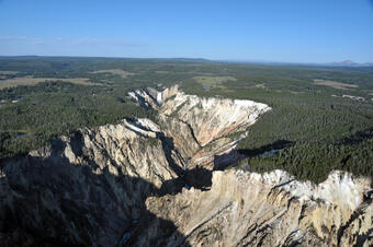
Stretching from the Lower Falls to the Tower Falls area, the Grand Canyon of the Yellowstone is about 28 km (17 miles) long, 250–350 meters (820–1150 feet) deep, and 450–1200 meters (1500–4000 feet) across. It appears to be a surprisingly young feature of the region, having mostly formed during and immediately following the last ice age, within the past 20,000 years or so. The geological story of the canyon, however, begins immediately after the formation of Yellowstone Caldera.
About 631,000 years ago, the most recent massive explosive eruption evacuated so much magma that the ground collapsed to form a giant crater, called a caldera. Soon after, magma began refilling the subsurface chamber, pushing the ground surface upward and forming “resurgent domes” on the east and west sides of the caldera. This uplift resulted in the creation of many faults, including some in the area of the future Grand Canyon of the Yellowstone.
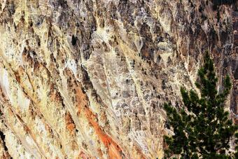
The next major geological activity in the region was the eruption of flows of rhyolite lava and some ash about 480,000 years ago. These lava flows are not like those in Hawaiʻi, but instead are many hundreds of feet thick, and they flowed very slowly. Following the eruption of the lava, hydrothermal activity began to take hold in the region, with gases over 150 °C (300 °F) in temperature channeled into the area. These gases rose to the surface along the faults that formed because of the resurgent doming.
By about 150,000 years ago, the area was the site of a vigorous acid-sulfate thermal area that might have looked a little bit like the Mud Volcano region looks today, with boiling mud pots and fumaroles emitting sulfur gases and other compounds. We know this from looking at the rocks exposed in the canyon walls. The colorful reds, oranges, and yellows indicate that the original rhyolite lava flow has been broken down into clay minerals, iron oxides, sulfur, and other compounds due to hydrothermal alteration as acidic gases and water circulated through the subsurface. There is even evidence for pipe-like features within the canyon, marking the pathways that acid gases took to the surface.
There might have been a small valley in the area at that time due to erosion by the Yellowstone River, but it probably wasn’t very deep. Certainly, it was not yet “grand,” but the stage was set.
By 22,000 years ago, a thick ice cap covered Yellowstone as part of the Pinedale glaciation. As those glaciers began to retreat, it is possible that an ice dam formed somewhere near Yellowstone Lake, causing water to temporarily back up. A similar ice dam during the previous Bull Lake glaciation, about 150,000 years ago, near the Canyon area resulted in the formation of a lake that today is marked by Hayden Valley. The Pinedale ice dam could have failed and reformed repeatedly between 18,000 and 14,000 years ago, releasing torrents of water that caused rapid erosion of the canyon. It is also possible that the canyon was scoured, in whole or in part, by sudden outbursts from Yellowstone Lake after the ice was gone. There is evidence from geological deposits that earthquake-triggered tsunami have occurred on the lake, causing large flows of water down the Yellowstone river.
Regardless of the source, we know that it was flooding by water, and not erosion by glaciers, that created the canyon because of the feature’s V-like shape (glacial canyons have U-like shapes). The area of the present canyon was especially susceptible to erosion because of the presence of the faults and widespread hydrothermal alteration, which weakened the rock. These faults and the contrasts between the weak canyon rocks and stronger rocks upstream control the locations of the Upper and Lower Falls today.
The story of the Grand Canyon of the Yellowstone is the story of the region itself—of massive explosions, uplift and faulting of the ground, thick lava flows, abundant hydrothermal activity, massive glaciers, and raging rivers!
Stories about:
Story Categories:
A copy of National Parks Traveler's financial statements may be obtained by sending a stamped, self-addressed envelope to: National Parks Traveler, P.O. Box 980452, Park City, Utah 84098. National Parks Traveler was formed in the state of Utah for the purpose of informing and educating about national parks and protected areas.
Residents of the following states may obtain a copy of our financial and additional information as stated below:
- Florida: A COPY OF THE OFFICIAL REGISTRATION AND FINANCIAL INFORMATION FOR NATIONAL PARKS TRAVELER, (REGISTRATION NO. CH 51659), MAY BE OBTAINED FROM THE DIVISION OF CONSUMER SERVICES BY CALLING 800-435-7352 OR VISITING THEIR WEBSITE. REGISTRATION DOES NOT IMPLY ENDORSEMENT, APPROVAL, OR RECOMMENDATION BY THE STATE.
- Georgia: A full and fair description of the programs and financial statement summary of National Parks Traveler is available upon request at the office and phone number indicated above.
- Maryland: Documents and information submitted under the Maryland Solicitations Act are also available, for the cost of postage and copies, from the Secretary of State, State House, Annapolis, MD 21401 (410-974-5534).
- North Carolina: Financial information about this organization and a copy of its license are available from the State Solicitation Licensing Branch at 888-830-4989 or 919-807-2214. The license is not an endorsement by the State.
- Pennsylvania: The official registration and financial information of National Parks Traveler may be obtained from the Pennsylvania Department of State by calling 800-732-0999. Registration does not imply endorsement.
- Virginia: Financial statements are available from the Virginia Department of Agriculture and Consumer Services, 102 Governor Street, Richmond, Virginia 23219.
- Washington: National Parks Traveler is registered with Washington State’s Charities Program as required by law and additional information is available by calling 800-332-4483 or visiting www.sos.wa.gov/charities, or on file at Charities Division, Office of the Secretary of State, State of Washington, Olympia, WA 98504.

National parks and their natural resources belong to you. The National Parks Traveler works to ensure you know how these essential places are being cared for.
Sign Up For Our Weekly Newsletter
Unsubscribe at any time.
INN Member

The easiest way to explore RV-friendly National Park campgrounds.

Here’s the definitive guide to National Park System campgrounds where RVers can park their rigs.
Our app is packed with RVing- specific details on more than 250 campgrounds in more than 70 national parks.
You’ll also find stories about RVing in the parks, tips helpful if you’ve just recently become an RVer, and useful planning suggestions.
