
To see Cape Breton Highland's Skyline trail without the crowds, consider a winter snowshoe/Destination Cape Breton Association
The Quandary Of Cape Breton Highland’s Most Popular Hike
By Jennifer Bain
For four enchanting hours, we are alone on Cape Breton’s most iconic trail, snowshoeing through silent forests, passing through a barren area protected from browsing moose, rejoicing when a final stretch of boardwalk ends on an oceanside cliff with jaw-dropping views of the Gulf of St. Lawrence and the snake-like Cabot Trail highway.
There are prints in the snow from squirrels, rabbits and moose, but no signs of the animals themselves. There is evidence that human adventurers set out ahead of us today, but they have come and gone.
As the wind stirs up snow so it lightly covers our tracks, Parks Canada’s Tammy Aucoin likens this western part of Cape Breton Highlands National Park to a snow globe. It does feel like we’re in a miniature bubble. It’s impossible to believe, though, that come summer there will be upwards of 1,000 people hiking this trail every day, filling the air with chatter, creating a bottleneck when the boardwalk comes to its photogenic end, and maybe even stepping off the boardwalk and damaging the fragile ecosystem the park tries so hard to protect.

The first part of the Skyline trail goes through forest/Jennifer Bain
To hike Skyline trail or not to hike Skyline trail, that is the question that haunts the responsible traveler.
Established in 1936 as Atlantic Canada’s first national park, Cape Breton Highlands covers 948 square kilometres (366 square miles) and protects about 20 per cent of northern Cape Breton Island in Nova Scotia. The park is an anchor for regional tourism and sells itself as the place “where the mountains meet the sea.” It offers spectacular highlands, steep cliffs, deep river canyons, forests (Acadian, boreal and taiga) and ocean scenery. One-third of the Cabot Trail — a world-famous scenic highway — runs through it.
Slightly more than 301,000 people visited in 2019-20, before the pandemic skewed numbers. They came to hike, bike and camp, exploring 30 kilometres (81 miles) of front-country hiking trails. Of the two dozen marked trails, Skyline is the undisputed favourite, ending at that dramatic headland cliff and offering the chance to see moose, bears, whales and eagles.

You can do a shorter, or longer, version of Skyline trail/Jennifer Bain
Skyline draws 50,000 visitors a year, so many that Parks Canada won’t promote it through social media this summer, although it will still lead sunset hikes for $15.50 Canadian (about $12) per person. Skyline is easy and accessible, but not quick. Without the snow to slow you down, it still takes two to three hours, depending on whether you hike there and back on a 6.5-kilometre (4-mile) trail, or add in a rugged back loop that ups things to 8.2 kilometres (5.1-miles).
When a place suffers from overtourism, we find an alternative or visit when (and if) the crowds thin to help extend the tourism season. So what about experiencing Skyline in winter, when the trail might get a handful of weekend visitors and nobody on a weekday?
Skyline does make the list of ungroomed winter trails that Parks Canada recommends. But travelers are warned to prepare for sudden weather changes and consider carrying GPS since wind can cause snow drifts that quickly cover their tracks. Parks Canada says foot traffic, ski poles and snowshoe cleats can damage the rare and fragile vegetation along the trail, even under snow cover, and that snow drifts can disguise cliff edges. Oh, and if the parking lot isn’t plowed, you’ll need extra time to reach the trailhead.

This part of Skyline's parking lot is not plowed when we start our snowshoe/Jennifer Bain
That’s what happens when Aucoin and I meet on a Wednesday afternoon in between two storms. I’ve chosen the friendly Cheticamp Outback Inn in the picturesque Acadian fishing community of Chéticamp as my base, and packed oatcakes (Scottish-inspired biscuits) from La Boulangerie Aucoin Bakery.
It’s only a 20-minute drive from my inn to Skyline, but part of the sprawling parking lot hasn’t been plowed so we’ll have extra ground to cover. At least the pit privies (outhouses) are unlocked.
Aucoin — a Parks Canada visitor services team leader and Destination Cape Breton “adventure ambassador” — has done this trail hundreds of times, sometimes just to catch the sunset. But 30 minutes into our outing, one of my new snowshoes falls apart. I’m not turning back, so hike behind Aucoin’s snowshoe trail, trying not to sink or complain.

Parks Canada's Tammy Aucoin gets ready to open the moose "exclosure" gate/Jennifer Bain
The tranquil forest ends abruptly.
“It may seem strange to leave a thick, forested path and enter large, grassy fields,” says an interpretive sign for the "Bring Back the Boreal" restoration project. “Where did all the trees go? The answer is quite simple — our neighbourhood moose are eating them! In fact, our researchers know that the eating habits of hungry moose have turned one third of the Park’s boreal forest into grasslands.”
Aucoin leads us to a fenced area the size of nine football fields and opens the gate. This “moose exclosure” was built in 2007 to keep moose (but not smaller creatures) out and protect thousands of balsam fir saplings from being eaten. There’s a toll-free number to call if you spot a moose inside and a viewing platform, but given my snowshoe fiasco, we skip the extra trek off trail and slightly uphill.

The exclosure keeps moose out and gives saplings a chance to grow/Jennifer Bain
What I do learn from reading the panels is that while spruce budworm infestations are part of the natural cycle of the boreal forest, a 1970s outbreak wiped out 90 per cent of the forest cover in some areas. New growth of young trees and shrubs provided perfect food for moose. But since these moose don’t face natural predators or disease here, their population grew to more than four times what is healthy and stopped the forest from regenerating.
“By now you would expect to see a maturing birch forest with a new generation of balsam fir waiting to grow,” a sign explains. “Instead, the ecosystem has changed to this savannah-like one.”
A five-year “Bring Back the Boreal” project ran until March 2019 to reverse the trend of boreal forest becoming grasslands. The Skyline trail — one of two focus areas — got more than 16,000 new trees along it plus another 51,000 white spruce and balsam fir near it.

The first view of the Cabot Trail, a world-famous scenic highway/Jennifer Bain
Leaving the exclosure, we re-enter the forest and finally hear signs of life — in this case, trucks on the Cabot Trail. The path veers over to a viewpoint where we can admire French Mountain. It’s lovely but would an be astounding when the fall colours are out.
Under the snow, the wheelchair-friendly trail is apparently covered in gravel. Finally, we reach the boardwalk — a front-row viewpoint to Parks Canada’s conservation efforts. Built from 1997 to 2001 to protect the fragile habitat on the headland, it also aims to keep visitors safe from life-threatening falls and human-wildlife conflict on the narrow headland.

Parks Canada's Tammy Aucoin breaks a trail at the start of Skyline's boardwalk/Jennifer Bain
“This rugged yet fragile headland took thousands of years to evolve,” an interpretive panel explains. “Low-growing crowberry, grasses, blueberries, stunted spruce and windswept juniper hold this habitat together. Rare and unusual plants and animals live here. Stepping off the boardwalk tramples plants, killing their sheltering leaves and roots. Then the life-supporting soil is blown away by fierce winds, leaving only rocks.”
The boardwalk has steps in places and “hides behind rocks and snuggles down into the ground to escape the wind.” Its “roots” are 15-millimetre (1/2-inch), stainless steel, and bolted and epoxied to bedrock.
The sun has broken through the clouds on an otherwise grey day and it’s noticeably colder and windier here than anywhere else on the trail. I consider following the boardwalk down the headland to a lower viewing point, but fear I might slip on the snowy wood.

Part of Skyline's boardwalk goes down the headland to a lower viewing area/Jennifer Bain
Instead, I study several small but colourful signs at foot level. “Just one step can harm habitat for plants and animals, loosen soil and erode the cliff. Sensitive Habitat. Please stick to the boardwalk!” One shows rare golden heather, a small heather-like evergreen plant that only grows on dry rocky or sandy exposed soils.
Another sign warns “you are required by law to stay on the boardwalk at all times,” but doesn’t spell out what the repercussions are for disobedience (apparently hefty fines). I already know that far too many people — many of them new to national parks — continue to walk where they please and even create unofficial “trails” that tempt others. Parks Canada contracted Bath & Associates to study this behaviour for a report. Company president Alistair Bath, who's a geography professor at Memorial University of Newfoundland (MUN), is an expert on human-wildlife conflicts and human dimensions in natural resource management issues.
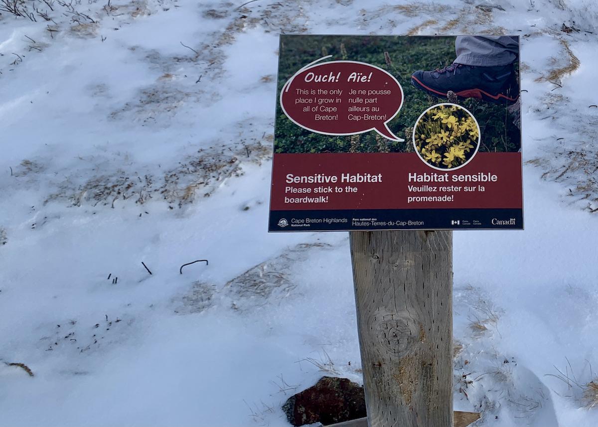
Signs urge people to stick to the boardwalk to protect sensitive plants.
Still, I get why people (like me) are drawn here. The view is unrivalled and, after seeing it in so many photos, it’s all the more satisfying to see it live. But take a deeper look and realize that this type of headland barren isn’t common in Nova Scotia, and the plants that live here exist because the microclimate extremes make the area inhospitable to trees. It’s part of the habitat for bees, berries and more, but it isn’t resistant to foot traffic.
“The shrubs are hardy but they can’t survive repeated trampling,” Parks Canada says. It’s working with Saint Mary's University in Halifax to rehabilitate the degraded vegetation, restore this important ecosystem and remind visitors to respect nature.
Four treatments are being tested to see what works best to reverse this damage. Nearly 500 bags of topsoil have been hauled here, and some protective matting has been installed, though we can’t see it today.

Sunsets at the end of the Skyline trail are stunning/Jennifer Bain
As we take one last look and turn to head back, I realize that the snow has also obscured artist Lorraine Albert’s 35 brass plaques on the boardwalk steps. They are laser etched with text from the Peace and Friendship Treaty signed in 1752 between the Mi’qmaq and Wolastoqiyik (Maliseet) people and British Crown. The Steps Forward installation — which Albert hopes creates a “reflective, sobering and educational experience” —conveys that whether Indigenous or settler, we are all treaty people.
Cape Breton Highlands is a place of cultural and spiritual significance to the Mi’qmaq of Nova Scotia. Parks Canada plans to boost the Mi’qmaq presence here with more heritage interpretation programming, events and celebrations.

Tammy Aucoin has done the Skyline trail hundreds of times in all seasons/Jennifer Bain
People are keen to make deeper connections with this trail and with this park. They want to see year-round offerings here in one of the few parts of Nova Scotia that has reliable snow, according to a 2022 draft management plan. Snowmobiling is forbidden and that won’t change, but a more challenging, long-distance hiking trail is possible, perhaps with rustic accommodation.
Four hours hiking Skyline without snowshoes just about does me in, but Aucoin and I make it back to our cars just as darkness falls. As grateful as I am to have experienced the park's most popular trail without having to jostle with annoying crowds, I know I’ve missed important things along it because of the snow. I'll be watching to see what the Parks Canada/MUN boardwalk study has to say about better managing Skyline's popularity (perhaps with reservation) and making sure people don't stray from the designated paths.
Once the snow melts, I will try Skyine again, ever respectful and always eager to keep learning.
Add comment