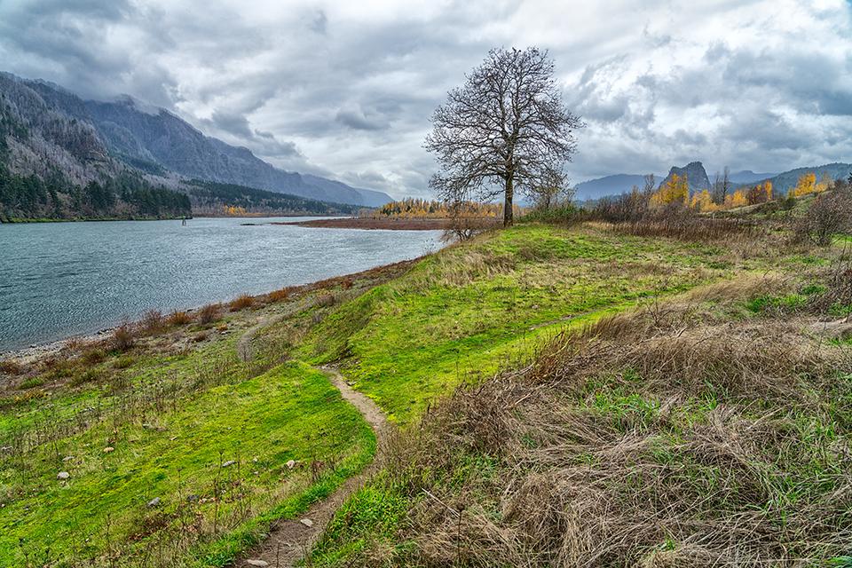
Following the path of the Columbia River on the way to Beacon Rock, Lewis and Clark National Historic Trail / Rebecca Latson
Before I’d ever heard of the Lewis and Clark National Historic Trail, I’d read an interesting article in a local Yakima publication about Beacon Rock State Park, which is actually located along this national historic trail paralleling the Columbia River. Since moving to the Pacific Northwest, I’ve been exploring various state parks and national park units within Washington and Oregon. So, when I found myself driving home from Mount St. Helens Volcanic National Monument one fine 2021 spring day along Washington State Route 14, and spied a sign pointing toward Beacon Rock State Park, I naturally had to stop and take my cameras to photographically explore this remnant of Washington’s volcanic past. Ok, in truth, hiking up Beacon Rock has been on my bucket list for over a year.
Pinpointing the location of Beacon Rock State Park along the Lewis and Clark National Historic Trail / National Park Service
In 1805, Captain William Clark wrote in his journals about this “remarkable high rock” where he first noticed the Pacific Ocean’s tidal influence on the Columbia River. Given a variety of monikers over the years, including “Castle Rock,” “Beaten Rock,” and “Inoshoack Castle,” the United States Board of Geographic Names, in 1916, restored Clark’s original name of Beacon Rock to this eroded basalt plug, the core of an ancient volcano.
The land was purchased by Henry J. Biddle, descendent of Nicholas Biddle, “the original editor of Lewis’ and Clark’s journals,” and later given to the state for a park. Today, a guard railed and (mostly) paved trail of over 50 switchbacks takes one on a mile-long zig-zagging hike up to the top of 848-foot Beacon Rock. Rock climbers enjoy testing their skills here, and the state park is open year-round for camping and picnicking in addition to biking, hiking, and fishing. You’ll get wonderful views of the rolling Columbia just about anywhere you choose to hike in this park, and the higher you climb on the Beacon Rock trail, the grander the views.
As a photographer, I like to capture not only more intimate landscapes around me, but also wide-angle overall shots of as much of the entire scene as possible. One of the things I neglected to do during my spring visit to Beacon Rock was acquire one of those overall images of the volcanic plug and it’s location in relation to the Columbia River. All I really photographed was the trail itself and the views from the trail. I guess I thought since it was a state park, rather than a national park, I wasn’t going to write any article for the Traveler about this spot. Now, here I am, some six months later, penning a series of articles about the Lewis and Clark National Historic Trail, which includes Beacon Rock.
If you ever travel to this state park, make certain you get that wide-angle shot, which I finally got during my November trip to Cape Disappointment State Park (April’s photo column), since Beacon Rock is along the way. This is why you see overcast images of Beacon Rock mixed in with shots taken on a much sunnier day back in the spring.
The route to a first view of Beacon Rock and the Columbia River, Louis and Clark National Historic Trail / Google Maps
If you are traveling west along WA State Route 14, you'll get a little glimpse of Beacon Rock from the road about two miles out. However, photographing it is difficult because trees obscure the view along the road, heading west or east. To get an overall shot requires a detour from the main road, by taking the turnoff to Fort Cascades Historic Site (a left turn if heading west). The sign might also say “Dam Access Road.” Once on the road, curve a little to the right but stay on the main road, passing the turnoff to Fort Cascades Historic Site, then further down the left turn to Hamilton Island Boat Ramp. Just keep going until the road ends at a small parking area with a pit toilet. The gravel Hamilton Island Trailhead eventually becomes grass, but it’s still a quite noticeable trail. Smaller paths run from that trail down to the rocky shore of the Columbia River. From there, you can capture nice wide-angle and telephoto shots of the Columbia River, Beacon Rock, and a part or all of Ives Island.
Beacon Rock in the distance, Lewis and Clark National Historic Trail / Rebecca Latson
Sighting the Beacon Rock, Louis and Clark National Historic Trail / Rebecca Latson
A telephoto view of Beacon Rock, Louis and Clark National Historic Trail / Rebecca Latson
If I had not been so focused at the time on reaching my Cape Disappointment destination, I would have spent more time hiking the Hamilton Island Trail as far as possible for close photos of the birdlife I’d noticed (after the fact) in one of my telephoto images. Enlarging the image for a better look, I managed to make out a heron standing in the water, a bald eagle, and a couple of other large birds on the shore behind the heron. If you enjoy bird photography, then it’s something to think about doing as a side trip on the way to this state park.
Looking up the height of Beacon Rock, Beacon Rock State Park, Louis and Clark National Historic Trail / Rebecca Latson
Starting the climb of Beacon Rock, Beacon Rock State Park, Louis and Clark National Historic Trail / Rebecca Latson
Once you arrive at the small parking area in front of the restrooms next to the Beacon Rock Trailhead, get a shot looking up the height this volcanic plug before starting your hike to the top. The trail is really easy and the views are grand. During your climb, periodically stop and photograph the Columbia River and surrounding landscape.
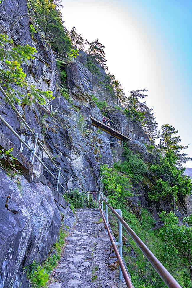
Going up the switchbacks along Beacon Rock Trail, Beacon Rock State Park, Louis and Clark National Historic Trail / Rebecca Latson
More switchbacks up Beacon Rock, Beacon Rock State Park, Louis and Clark National Historic Trail / Rebecca Latson
Along the way, frame a composition or two (vertical and horizontal) of the switchbacks against the sheer basalt rock. They aren’t anything like Walter’s Wiggles in Zion National Park, but they are still pretty cool as they zigzag their way up to the top.
The view upriver along the Beacon Rock Trail, Beacon Rock State Park, Louis and Clark National Historic Trail / Rebecca Latson
Take a breather from time to time and capture the view.
The view from the top, Beacon Rock State Park, Louis and Clark National Historic Trail / Rebecca Latson
Upon reaching the summit, make sure to get that one last image from your perch high above the Columbia River.
Stay tuned for the next installment of my photographic explorations along the Lewis and Clark National Historic Trail. You’ll see more of what Lewis and Clark saw during the final leg of their journey to the Pacific Coast and learn about photographing king tides off of Washington’s Cape Disappointment.
Note: to visit Washington state parks, you’ll either need to purchase an annual Discover Pass for $30, or you can fill out a day pass and pay $10. FYI, if you don’t have a pass and get caught, the resulting ticket can be pricier than the cost of an annual pass ($59 to $99).
References
Anthony Brandt (Editor), The Essential Lewis & Clark, 2002, National Geographic Partners, LLC
Stephen E. Ambrose, Undaunted Courage | Meriwether Lewis, Thomas Jefferson, And The Opening Of The American West, 1996 (2005 paperback edition), Simon & Schuster Paperbacks
https://www.nps.gov/places/beacon-rock.htm
https://stateparks.com/beacon_rock_state_park_in_washington.html


Add comment