
Chance of minor or greater damaging earthquake shaking in the next 100 years. Population exposure estimates are rounded to the nearest 1000/USGS
Rumbling and light shaking in Hawai'i are pretty common, as is the simmering of the Kīleau volcano, what with the volcanic plumbing that created the islands. Just the other day the U.S. Geological Survey's Hawaiian Volcano Observatory reported an earthquake with a magnitude of 4.3 that lightly shuddered the islands.
"The earthquake was centered about 8 kilometers (5 miles) east-northeast of Pāhala, at a depth of 34 kilometers (21 miles)," the observatory reported. "Light shaking ... has been reported across parts of the Island of Hawai‘i. At that intensity, significant damage to buildings or structures is not expected."
According to HVO Scientist-in-Charge Ken Hon, the earthquake had no observable impact on either the Mauna Loa or Kīlauea volcanoes that rise within Hawai'i Volcanoes National Park.
“This earthquake is part of the ongoing seismic swarm under the Pāhala area, which started in August 2019," said Hon. " Webcams and other data streams show no impact on the ongoing eruption at Kīlauea. "
While that quake appears to have been insignificant, what are the odds of a more dangerous and damaging eruption? According to the observatory scientists, they're pretty good.
"Hawai’i is a seismically active state, as indicated by the thousands of earthquakes recorded each year by the USGS Hawaiian Volcano Observatory," reports the USGS. "Damaging ground shaking has occurred over the decades, with two M6.7+ earthquakes in 2006 and 2018 and most recently a M5.2 earthquake on July 5, 2021, that was felt by more than 1,300 people and a M6.2 earthquake on October 10, 2021, that was felt by more than 3,500 people."
New modeling done by the USGS show that there's "a 90 percent chance that the 345,000 people on the islands of Hawai’i and Maui could experience damaging levels of shaking during the next 100 years (a blink of the eye in geologic time). A lower but significant chance of damaging shaking is expected across Oahu; within the southeastern portion of the island near Honolulu there is a greater than 50 percent chance of damaging shaking occurring during this period."
In a report issued in December, Mark Petersen, a USGS research geophysicist and lead author of the publication, said that "[T]he previous hazard model was developed over 20 years ago, and since that time we have experienced several large earthquakes, volcanic eruptions, and have collected deformation, soil, and strong motion data that can be used to improve this forecast. We collaborated with scientists and engineers across Hawaii and the rest of the U.S. to build these models. The new seismic hazard maps can be used to update building codes and other planning documents which should improve seismic safety across Hawai’i.”
The map and publication feature new earthquake catalogs, assessments of activity on active faults using geologic and geodetic measurements, and evaluations of strong shaking data to define the ground shaking levels expected from earthquakes on the Hawaiian Islands, the USGS said.
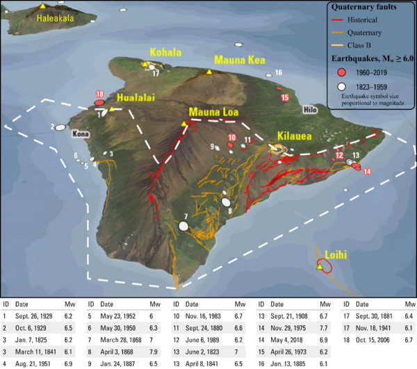
Earthquake sources on the Island of Hawaii include (1) locations of shallow Quaternary faults (solid lines, colors represent age of faulting), (2) locations of places where deep faults (décollements) are known (dashed lines), and (3) locations of volcanoes (triangles). Large M>6 earthquakes with dates and magnitudes shown in table below figure.
Ground shaking is forecasted to be highest near the active volcanos of Kīlauea and Mauna Loa in the southernmost portion of the Island of Hawai‘i. Here magmatic activity pushes the crust outward toward the ocean along a nearly horizontal fault located about 6 miles (10 kilometers) beneath the surface. Large earthquakes occurred on this zone in 1868, 1975, 2018 and 2021. The 2018 earthquake was followed by a volcanic sequence that included numerous seismogenic collapses of Kīlauea volcano’s summit crater floor. These provided data that helped define the shaking levels predicted by the model.
Despite the latest research, the USGS team says that, "[W]hile earthquake activity remains high today, it seems to have decreased compared to the preceding century, which could be related to less volcanic activity at Mauna Loa. Variations in earthquake activity are considered in the new models with the expectation that earthquake activity could revert back to previous levels or continue at the current level."


Add comment