
Tracks of the Emigrant Trail near South Pass, Wyoming/David and Kay Scott
South Pass: Pioneer Gateway To The Oregon Territory And California Goldfields
South Pass, located in southwest Wyoming, was the key that opened the door for emigrant wagons and handcarts to cross the Rocky Mountains in the early and mid-1800s. The 20-mile wide, sagebrush-covered saddle topped a gradual incline that appeared more like a prairie than a mountain pass.
By David and Kay Scott
Six years following the 1806 return of Meriwether Lewis and William Clark’s Corps of Discovery to St. Louis, Scottish-born fur trader Robert Stuart of the American Fur Company along with six companions set out to return east from Fort Astoria near the mouth of the Columbia River. While members of the Corps of Discovery nearly perished crossing the Bitterroot Mountains while heading west near today’s Montana-Idaho border, Stuart’s group learned from the Shoshones of a better path 400 miles further south and was able to ascend a gentle slope offering a relatively easy crossing of the Continental Divide.
The route used by Stuart had been known to Native Americans for centuries, but the fur trader and his companions are thought to be the first group of European Americans to utilize what would become known as South Pass, so named to differentiate it from Lemhi Pass used in 1805 by Lewis & Clark. South Pass would become one of the most important geographical locations in the development of the United States.
The men wintered in the southeastern corner of present-day Wyoming and arrived at Saint Louis in April of 1813. Upon their return, Stuart told others of the less demanding path over the Rockies, but with the United States in the midst of the War of 1812 government officials had their hands full and seemed little interested in Stuart’s information.
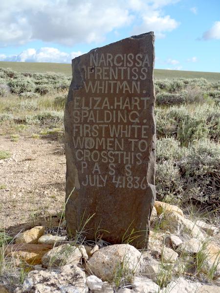
First women to cross South Pass were Narcissa Prentiss Whitman and Elizabeth Hart Spalding/Kurt Repanshek file
It wasn’t until 20 years following Stuart’s crossing that Captain Benjamin Bonneville, on leave from the U.S. Army, led the first procession of loaded freight wagons over South Pass on an expedition to explore the West. Four years later, missionaries including Marcus Whitman and Henry Spalding, along with their wives, crossed South Pass while headed to Walla Walla in today’s Washington state. The wives were the first two White females to traverse the pass.
The Bartleson-Bidwell party of over 60 members, including Jesuit priest Father De Smet, departed for present-day California (then part of Mexico) from near Westport, Missouri, in May 1841, to become the first emigrant group to cross South Pass on its way to a land that in 1850 would become the country’s 31st state. A minority of the party decided at Soda Springs in today’s Idaho to alter their destination and head to Oregon. The larger group stuck to the original plan and made it to California, but with great difficulty.
The early 1840s marked the opening salvo for over two decades during which South Pass served as the major gateway for several hundred thousand pioneers and prospectors, along with emigrants seeking religious freedom, to cross the country’s western spine. In addition to being the key location along main routes of the Oregon, California, and Mormon Trails, the pass was utilized by Pony Express riders and, in 1861, by Western Union’s construction of the St. Joseph to Sacramento telegraph.
Following the South Pass crossing, early pioneers headed southwest to Fort Bridger, a popular stop for supplies, repairs, and rest. With the 1844 opening of a western cutoff less than 20 miles after crossing South Pass, pioneers could choose whether to continue to Fort Bridger or head west to Fort Hall. The cutoff bypassed Fort Bridger and saved over two days of travel, but required travel through 50 miles of desert without access to water. Often called the “parting of the ways,” the pioneers’ choice generally depended on whether the destination was Oregon, California, or Salt Lake City.

David and Kay Scott on the Oregon Trail/Courtesy
Most 1840s traffic over South Pass consisted of families seeking to claim land in the Pacific Northwest. Few of these early pioneers had an interest in returning to the homes they had left. Following the 1848 discovery of gold at Sutter Creek in present-day California, traffic along the route increased considerably, and was primarily comprised of men planning to return home after striking it rich in the goldfields, although some returned east to bring their families west.
The great numbers of pioneer families able to reach and settle in Oregon are considered a key factor in preventing Britain from successfully claiming what is now the Pacific Northwest. Oregon country that was under joint administration of the British and United States was ceded by the former to the United States in 1846 with the signing of the Oregon Treaty. The land became a U.S. territory two years later, and achieved statehood in 1859. The history of the United States may have evolved much differently had there not been a South Pass that allowed thousands of pioneers relatively easy wagon access over the Rockies.
The overland trail over South Pass was not the only route pioneers frequented during their journeys west. Southerners often took a southerly route though Santa Fe, while Northeasterners often chose transport by ship around Cape Horn or via the Isthmus of Panama. The water route was more expensive and likely more boring, but certainly easier on the feet, since emigrants taking the land route typically walked rather than rode in the fully-loaded wagons.
The treeless, sagebrush covered land that includes South Pass is today overseen by the Bureau of Land Management and remains much as it was when pioneer wagon trains crossed in the mid-1800s. We have visited on two occasions during trips following the route of the Oregon Trail. During one trip we stood with two friends beside the monuments near the pass summit with no one else in sight. We could see one other couple in the far distance on our second visit. In each instance, we stood in near total silence with the Wind River Mountain Range to the north and Oregon Buttes to the south bordering one of the most important places in the history of our country. What a glorious experience.
David and Kay Scott are authors of “Complete Guide to the National Park Lodges” (Globe Pequot). They live in Valdosta, Georgia.
Traveler postscript: Before you set out to explore the trail, visit the Oregon Trail National Historic Trail Interactive Map and download the National Park Service mobile app to help plan and guide your visit to the Oregon National Historic Trail. There are a couple of BLM campgrounds near South Pass if you'd like to spend a couple days exploring not only the historic trail but also the South Pass City Historic Site, which is managed by the state of Wyoming.


Comments
Sometimes you just want to get away from the crowd somewhere where their is peace and quiet.Then this is the trip for you. This is also the trip to do your homework and mapwork before you go.There are few markers along the way to explain the full significance of what you are experiencing.Howeber with a little imagination along with your helpful information you can almost hear the cracking of the whips over the heads of the oxen and the creaking of the wagons and handcarts along a dusty trail. Yes, they pulled these handcarts by human power the whole way.These folks were not much worse off than those who had wagons that were too crowded and uncomfortable for their owners to hitch a ride. These were tough and determined Americans!
Wonderful article. I visited there once and faced 65mph winds that I thought were going to blow me away. A lot of history there though. I love anything I can get my hands on about the Oregon Trail.