High flows will be released from Glen Canyon Dam into the Colorado River as it runs through Grand Canyon National Park/NPS file
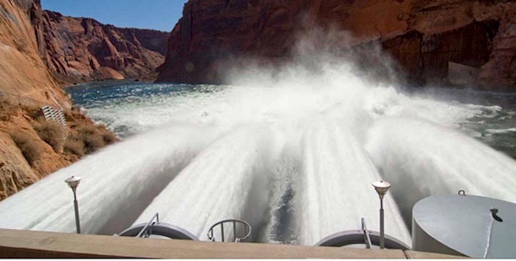
The Colorado River will be rocking and rolling through Grand Canyon National Park later this month as a "spring disturbance flow" is released from Glen Canyon Dam upstream.
The release is set for March 15 to 26. The operation will coincide with required maintenance on the concrete apron downstream of the dam and powerplant. The spring disturbance flow will not affect the monthly or annual release volumes from Lake Powell.
Lake Powell releases through Glen Canyon Dam will be reduced to 4,000 cubic feet per second beginning March 15. Flows will begin a gradual increase on March 20, will peak at 20,150 cfs on March 22 and will remain steady at that level until March 25. Typical flows in March range from a daily low of 8,000 cfs to daily highs around 15,000 cfs.
Standard operations will resume on the morning of March 26.
The disturbance flows are designed to simulate a spring-timed runoff event. As the changing flows disturb river bottom habitats, ecosystem responses may include elevated algae and insect production resulting in increased aquatic insect prey for endangered humpback chub, non-native rainbow trout, and other wildlife.
The flows also may affect the non-native brown trout in Glen Canyon by reducing survival of emerging young, which may help protect native fish in the river. Scientists will study the effects of the modified flows in Glen, Marble, and Grand canyons and the resulting data may be used to make future recommendations on how to better support the Colorado River ecosystem.
"Scientific studies like these are an important part of our obligation to effectively balance the need for water and power resources with responsible stewardship of the Colorado River ecosystem," said U.S. Bureau of Reclamation's Upper Colorado Basin Regional Director Wayne Pullan. "This spring disturbance flow was developed and proposed by agency experts from the Bureau of Reclamation, U.S. Geological Survey, and Western Area Power Administration in close collaboration with Colorado River stakeholders, with strong support from environmental and recreational interests. I applaud the partnership and collaboration of the Glen Canyon Dam Adaptive Management Work Group, including all seven basin states and five Native American tribes, to continue our successful adaptive approach to managing Glen Canyon Dam."
Additional information about this release will be posted and updated online at: https://www.usbr.gov/uc/progact/amp/DisturbanceFlow.html


Comments
Congratulations to all involved to find a compromise, our National Parks/Monuments need that kind of leadership. Keep up the good work, I have lots of Grandchildren I share the beauty of our National Parks, Thanks
Will continue to ruin this fishery. Zapping/killing fish, bounties on brown trout and all to protect a fish that nobody gives a damn about. Appreciate the efforts to simulate the runoff but let's not pretend they are doing what's best.
My rafting party was on the river in 2004 when the first major high flow event was created at 42,500 and we were given no warning in advance of the release. It was a bad sequence of events as were being chased by high water for the first half of the trip and one person in another party died in Hance, in part, due to the release. I made sure the NPS and BOR heard that this was a terrible way to treat private parties! Interestingly, what is now called a high water event is only around 20,000 cfs vs.what we had. That says something about pool levels and water conditions in the West. Not a good sign.
I was just at Lake Powell trying out my boat and doing some fishing end of February 2021. The lake was only at 39% full it was sad to see it so low. It seems to me some water storage should probably be considered as nature would be doing the same as what is going into the reservoir should be going out the whole point of the dam was for storage. Why can't the reservoir remain at a 75% full and then release the same amount that's going in and adjust accordingly isn't that the way nature would do it???
This comment is so dumb. You're actually advocating for destruction of an ecosystem to make your fishing trip better? Let's not pretend that what's best for you, is best for me, or the environment.
Because that would make too much sense
I have a few comments. First, it's true that Lake Powell's primary purpose is as a storage reservoir and trying out your boat and doing some fishing are, along with the other recreational uses, secondary; but, in that context, Lake Mead is also a storage reservoir that is critical in supporting the downstream "recreation" at Vegas. Water levels at Lake Mead is also extraordinarily low. So, in addition to enabling "required maintenance on the concrete apron downstream of the dam and powerplant" and simulating a once normal "spring-timed runoff event" that will benefit the aquatic and riparian environments, these flows will move needed water down to Lake Mead to support all that far more lucrative downstream "recreation" at Vegas. We all believe in capitalism and not socialism don't we?
Second, what is happening with regard to "pool levels and water conditions in the West" is certainly not a good sign. In fact, drought conditions are horrible and, according to some sources and based on some significant evidence, they could trend in that direction for up to as much a thousand years. Even if the reality turns out to be only fractionally as bad as those worst projections, both the current situation and the predictions are bad. It is highly likely that the need at Lake Mead and the financial forces in play will ensure that the far more lucrative downstream "recreation" at Vegas gets priority for how Lake Powell water gets used. Regardless of today's political performance art, money talks, especially in Utah. Again, we all believe in capitalism and not socialism don't we?
Third, I think we need to remember that construction of the dam at Glen Canyon drowned once scenic canyons and is now well on its way to filling them with silt under Lake Powell. Over the longer term, which might not be as long as we might think, the combination of drought-impaired lower flows into Lake Powell and Lake Powell's notoriously high siltation rates will reduce the depth of that reservoir, increase evaporation rates, and decrease Lake Powell's value for water storage. I know the people in that part of the country and, at some point, the value of selling that water and using the flats created at the bottom of Lake Powell for agriculture and development will begin to outweigh the value of the remaining mud puddle. The dam at Glen Canyon will start to be seen as just one more anachronistic liability that needs to be "repurposed" if not removed, perhaps leaving some remnant concrete to memorialize the area's mostly revisionist and reinvented "pioneer" heritage. The river will be channelized and controlled, partly for local irrigation, but most of the water will be sent directly down to what's left of Lake Mead. It will take a long time and, for some, it might be sad. No more nonnative fish to be caught by nonnative Americans; but, again, we all believe in capitalism and not socialism don't we?
Blowing out the spawn, zapping fish for selective removal and bounties isn't really protecting the ecosystem. Simulating a runoff is one thing, the actions taking place are a bit more. And yes, guilty of wanting to preserve this world class fishery.