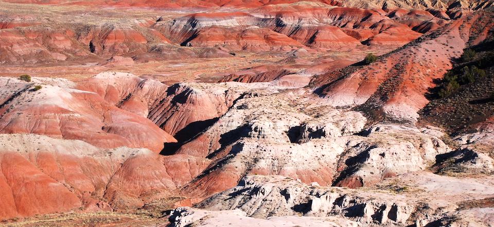
Petrified Forest National Park's Painted Desert/Kurt Repanshek file
Editor's note: There is just one road through Petrified Forest National Park, a road that most visitors stick to as they stop at overlooks, maybe hike to Agate House, and check out the Rainbow Forest Museum. But if you're adventurous, the Painted Desert with its backcountry trails holds surprises if you take the time, and have the skills, to explore this wild side of the park, as Barbara Jensen did.
Just west of Crazy Creek, the northern Arizona landscape expands, opening into the banded hues of the Painted Desert. Each different colored layer of rock was laid down in its own time, spanning millions of years, as the eons buried the evidence of Triassic forests and flowing rivers like hidden treasure, covered by volcanic ash and mud.
It is here, in the Painted Desert, that you discover Petrified Forest National Park. While you cannot gather the petrified wood found nearly everywhere in the park, this is still a place of unexpected rewards. How should you explore this colorful landscape? Here are some suggestions.
Day 1: Even though camping is currently prohibited due to COVID, I obtain a free backcountry hiking permit at the Painted Desert Visitors Center. The last one was issued seven days ago. With this permit, I have the 14,650-acre Devil’s Playground wilderness all to myself.
The park’s directions to access Devil’s Playground are detailed and accurate. However, once I park, I must immediately begin wayfinding. I am as perplexed as my GPS trail app until I scout forward to the northwest and see that the hill where I am allowed to park is in fact a steep bluff; a few feet forward is quite a few feet almost straight down. From its edge, l gaze out over the confluence of two seasonal river beds. The larger of these is Lithodendron Wash. I also see a dirt access road leading to the wash; it is Black Curve Road that I followed in from the highway. Now oriented, I can follow a faint trail down the bluff face, or simply cut over to the road.
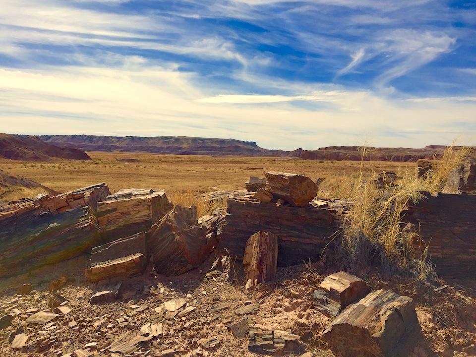
The Lithodendron Forest in Petrified Forest National Park/Barbara Jensen
I cross Lithodendron Wash, the sand sculpted by wind and water into beautiful feathery patterns. I see two flat, brown posts with Park Service arrowhead emblems planted like a gateway to my right, where I enter the 7.5-mile Devil’s Playground Loop Trail.
An old metal windmill in a wooden framework stands just beyond a sagging, rusty barbwire fence. In several places, the Loop Trail follows the National Park wilderness boundary, abutting private land. At other times, the trail follows dry washes, making navigation easy and quiet, my footfalls muffled by fine sand. Broader wash areas that channel the sporadic monsoon rains of early summer now roll with dry dunes of this soft, white sand sprouting clumps of hardy grasses. The path is crisscrossed by deer and coyote tracks. I spook a jackrabbit, so close I can clearly see the black tips on its long white ears, looking like eagle feathers.
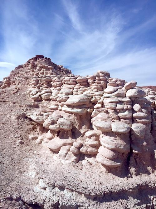
Hoodoos in the white layer formation/Barbara Jensen
White hoodoos emerge from their stone layer, revealed beneath an overlay of red rock, as if geologic time has been inverted. Small chunks of petrified wood are sprinkled along the trail, red and green and glittering with crystal veins. I had thought the hiking would be difficult, given the area’s harsh appearance, but it is actually quite easy, moderate when climbing drainages or scrambling over low rock formations. By using GPS and carrying a gallon of water, the Devil’s Playground has been transformed into a meditative walk in restful solitude.
I return to my car and head east on I-40. I’ve heard about lakeshore camping near Winslow, Arizona. Clear Creek Reservoir was created by flooding about eight miles of a low canyon; McHood Park, a small campground on the reservoir, is a little oasis in the desert. As I park at a campsite, I pause in my unpacking, watching fish jump, ducks circling to land on the water surrounded by green reeds and the canyon’s stacked stone. I pitch my tent under a dark desert sky filled with stars.
Day 2: A red pickup drives slowly through camp, stopping in front of me as I’m packing up this morning.
“You freeze last night?” asks Larry, the friendly camp host, with a big smile. After 40 years as a railroad man, Larry has spent the past 15 summers at McHood. “You been into town yet?”
He invites me to join him and his buddies for coffee and the news of the day at the Sipp Shoppe downtown. And there they sit, directly across the street from the Standin’ on The Corner Park, where Eagles music plays during business hours. Taking it easy with Larry and the boys, they regale me with stories of the journeys that led them each to Winslow. I am sworn to secrecy by instant loyalty to these gregarious, open-hearted men, but suffice it to say, they’ve lived colorful lives.
This is the glory of the Painted Desert: unexpected treasures lie right at our feet, easy to find, like sparkling petrified wood, and Winslow, and McHood Park, and Larry and the crew.
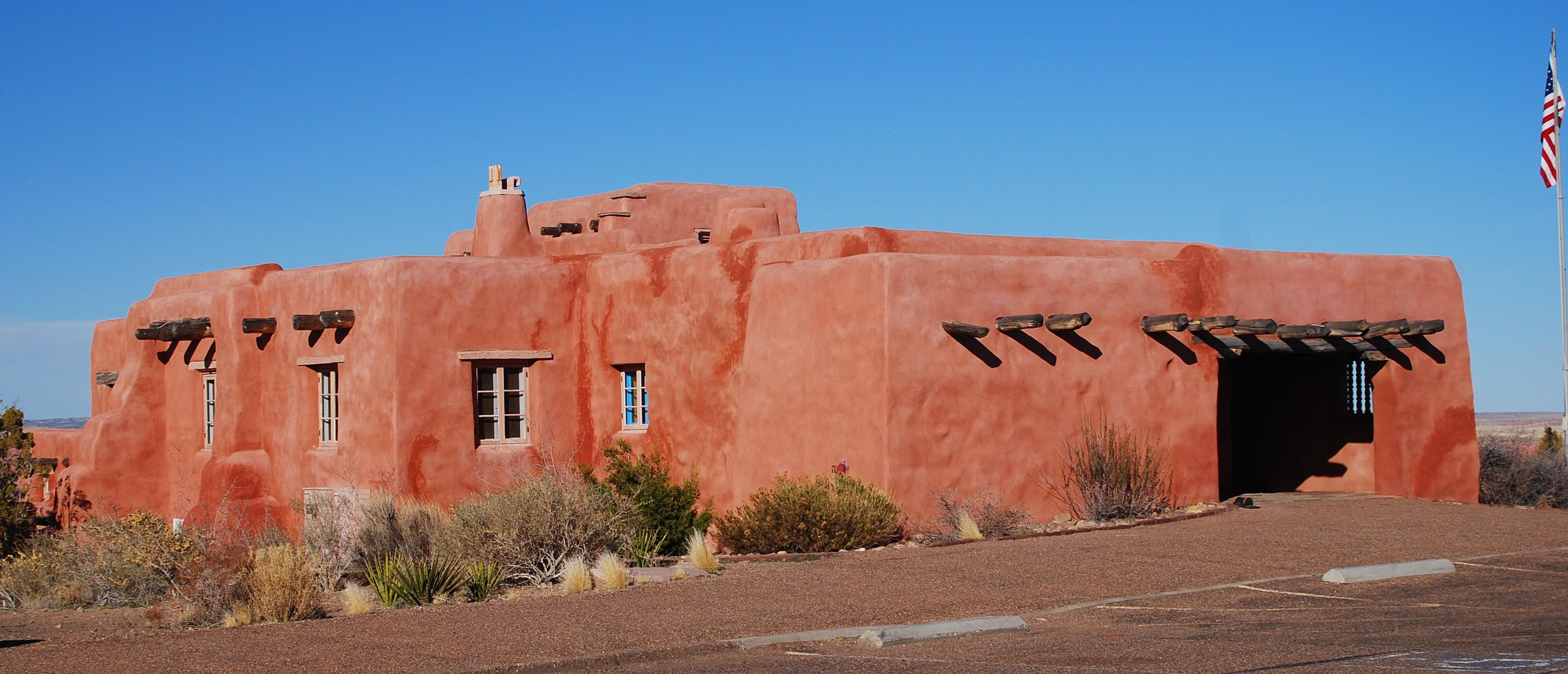
The Painted Desert Inn, Petrified Forest National Park/Kurt Repanshek file
I enter Petrified Forest National Park through the northern gate, parking at the old Painted Desert Inn to explore the seven-mile Wilderness Loop Trail. Printed trail guides with topo maps and GPS coordinates are available at the Visitors Center; today, I’m practicing my wayfinding the old way, using landmarks, these maps, and a compass. The trail starts next to the inn, descending stone steps to steep switchbacks that lead to encrusted red dunes on the desert floor. The trail guides me out to Lore’s Bridge, the stacked stone foundation of Herbert Lore’s 1930s plan to bring tourists to see the Petrified Forest. From the bridge, the trail turns toward Flatiron Rock covered in petroglyphs, and then on across Lithodendron Wash.
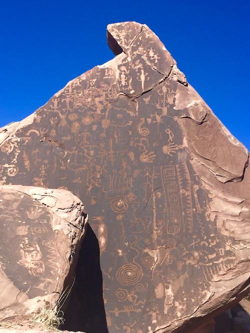
Flatiron Rock in the Painted Desert of Petrified Forest National Park/Barbara Jensen
After climbing up out of the designated drainage through these color-striped badlands, I find myself on the white layer, with no trail but the faint, crumbling boot tracks of hikers gone before. It is an otherworldly place, blinding under full sun, still hot in late October.
My pack is heavy with water. The map directs me to continue due north, which looks like walking off to my doom in this maze of nearly indistinguishable eroded rock cones and pinnacles. But after a few wrong turns around a half-dozen white hills, I find Angel’s Garden, petrified trees that lie broken into chunks bigger than me, alongside the nearly whole Twin Logs.
Again, the way north looks dubious, my only guidance to “keep the red badlands to your right” and “pick your way along like this until you start to see the next deposit of petrified wood.”
The reference photo looks nothing like the area around me. I try several possible routes, but there seem to be red badlands in front of me as well as to my right. I finally find what I’m guessing is the Chalcedony Forest, but that seems premature – have I gone far enough north yet?
I can’t have. And where is Lore’s road grader, the heavy wooden horse-drawn implement abandoned high in these hills? With only two hours left before the park closes, I reluctantly retrace all my steps, climb the switchbacks back up to the Painted Desert Inn, and drive back to McHood. Because I pushed it to the last minute, the sun has already set when I arrive. Larry’s camper is already dark, his door shut. Instead of firing up my stove and chatting over a hot meal, I nibble some trail mix while I pitch my tent, then wash up and climb inside to sleep.
Day 3: The morning wakes me with tiny swifts chittering as they fly over my tent, ducks quacking and diving on the lake for their breakfast. Thin, high clouds have softened the sunlight and let me sleep in.
Well-rested, I return to the Wilderness Loop Trail, determined to find the old road grader by coming up the trail the back way. I will connect the loop by backtracking, meet myself in the middle, as it were.
Retracing the beginning of the hike to the petroglyphs, I now follow the ever-present Lithodendron Wash upstream, its wide visibility comforting. The way to Onyx Bridge is up here. I scouted its entrance wash yesterday, before I gave up, defeated after Angel’s Garden. I could turn on my GPS, but I’m enjoying the challenge of the hunt. As I locate the wash, a dad and his young teenager come hiking up the wash behind me. We exchange pleasantries as I set down my pack.
“You okay?” he asks.
“Yeah, just getting water,” I reply, nodding. They hike away up the wash. I drink from my water bottle, wondering now if he knows the exit point of the loop trail farther up that way. I should have asked him.
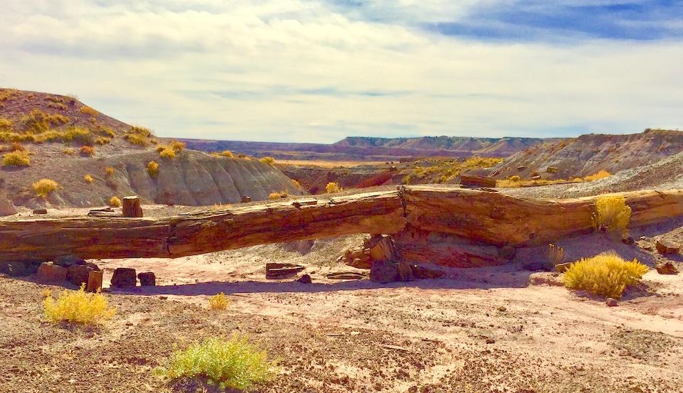
The Onyx Bridge in the Painted Desert of Petrified Forest National Park/Barbara Jensen
The climb up to Onyx Bridge is easy and straight-forward, the view long and restful. I’m just heading toward the route down when here come the dad and teen.
“Oh, hello – again,” he grins. “I guess we should have followed you.”
I smile and point back over my shoulder. “The bridge is right back there.”
“The bridge?”
“Yeah – Onyx Bridge. You made it!” A wide smile spreads over the teenager’s face and, leaving them happily taking pictures, I descend the drainage back to Lithodendron Wash, my day brightened, my confidence boosted.
I follow the wide riverbed until I find what I believe is the exit of the Wilderness Loop. Sure enough, I soon find the Lithodendron Forest, a mass of petrified logs on a small hilltop that perfectly matches the map. I navigate up a wash spilling stunningly colored petrified logs everywhere. It’s an easy climb, like a staircase, back to the white layer. I’ve got this, I think.
But I haven’t got this. I can’t find the road grader landmark, even after roaming at least a half-mile to my left and right. I look for the outcroppings in the map photo, but they are nowhere to be found. Where is this thing hidden?
Before I give up again, I decide to go an hour north and see what I find. I mark my easy drainage with a three-rock cairn, then head off north, keeping the wide wash to my right. The farther I walk, the lower the red badland hills become. I reach the end of the red hills, and turn to swing around them.
And that’s when I spy my prize: not the wooden road grader – a band of wild horses, grazing on the sparse grasses of this high plateau. Thrilled, I creep as close as I can without them noticing me. Then, encouraged by their relaxed comradery, I graze too, thoroughly enjoying the trail mix of my lonely camp supper from the night before. Half-lost in this wild place, I feel relaxed and free among its untamed inhabitants. Now mellow and satisfied, I handily locate the cairn and descend to Lithodendron Wash, following it back to the Painted Desert Inn under soft wisps of clouds blowing like the horses’ long tails.
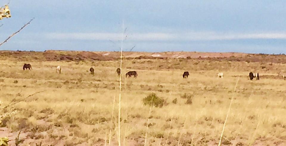
Look hard enough in the park's Painted Desert landscape, and you just might spy some feral horses/Barbara Jensen
Day 4: Wind rattles my tent through the night at McHood Park. Still, the morning dawns quiet and calm, and I wake at 6:30, ready to get started. The sunrise in thickening clouds reminds me that I have one more day in the Painted Desert, on Blue Mesa, before nasty weather is forecast to roll in.
Before I leave my campsite, I look over at the lake. I am covered in dried sweat, salty and dusty. Stripping down to my underwear, I wade into the cool water and rinse off. The morning dip refreshes and energizes me.
Today, I will hike the Historic Blue Forest Trail, just off the main road in the south half of the park. Constructed in the mid-1930s by the Civilian Conservation Corps, it originally connected upper and lower Blue Mesa Roads. It was decommissioned in 1955, when the paved Blue Mesa Loop was finished. But in 2013, the park brought back the original Blue Forest Trail, “for adventurous hikers.”
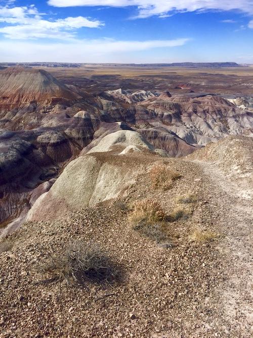
The Historic Blue Forest Trail/Barbara Jensen 500
It’s only three miles roundtrip. It seems so simple, following the old gravel roadbed and then a well-marked if narrow footpath. But this old trail rises 300 feet in just 1.5 miles, steep and unprotected, with significant drops on either side. Petrified logs lie shattered into splinters and slivers, scattered down into deep ravines.
As I start my hike, the day is still mellow and sleepy, cool with clouds ranging overhead. Still, I put on my rain jacket, just in case. As I climb higher, a breeze picks up. Then a full wind arrives. By the time I reach the top, a thirty-mile-an-hour gale is blowing, with alarming gusts well over that. What a feeling, to have risen so high above the rainbow-colored hills below me; and what a feeling as well, the wind now trying to fly me like a kite out over those hills.
THIS is the Devil’s Playground, I think ruefully, crouched low, “carefully picking my way along” and leaning hard against the howling fury, my jacket snapping. At least the trail is easy to find, though my eyes are watering in the fierce winds.
Historic Blue Forest Trail, right off the main park road, is the hardest trail I have encountered – because I underestimated it. A final surprise. The wind stirs up dust devils all across Petrified Forest National Park.
Maybe I’ll drive back to Winslow, get some coffee with Larry and the boys, and find a safe haven from the storms that blow in quickly across the Painted Desert.
Barbara Jensen is a writer and artist who likes to go off-grid, whether it's backpacking through national parks, trekking up the Continental Divide Trail, or following the Camino Norte across Spain. For over 20 years, social work has paid the bills, allowing to meet and talk with people living homeless in the streets of America. You can find more of Barbara's work on Out There podcast and www.wanderinglightning.com
Follow@wanderlightning [email protected]


Comments
Interesting to see that this petroglyph now has a name (Flatiron Rock). When I found it 25 years ago (April 1995), the rangers never spoke of it, nor was it on any maps. There was merely a small metal dogtag a few feet from it, indicating that it had been catalogued. I'm sure the park service at the time felt that anonymity was its best protection, seeing as how there was already some unwelcome vandalism etched onto it (the "LU"). I was completely alone for a few hours on that hike, and the timing was such that I chose to have lunch on one of the sandstone slabs next to the rock; I thought of it as a nicely decorated but upturned dining room table next to me.
Comparing photos then vs. now, I see some weathering (I hope that's all it was) on the upper right side. The first bit is additional fracturing and small pieces missing just right of the large croseed "X" cracks; second is a now-missing piece of dark patina at about a 5-o'clock position below that - - the narrow dark neck wasn't narrow back then. Also, the foreground rock's upper right corner is much more fractured now; fortunately, this is not a patina or petroglyph section.
Let me know if you're interested in comparing photos.