
The Chimney 2 Fire led to closure of the Newfound Gap Road at Great Smoky Mountains National Park on Monday. It attracted the attention of tourists on Sunday/NPS
Editor's note: This updates with a fire spotted near the Twin Creeks area of the park, a voluntary evacuation issued for the Mynatt Park neighborhood of Gatlinburg, firefighters from Utah expected to arrive to help with the suppression effort, and a forecast calling for wind gusts possibly reaching 85 mph.
A wildfire burning not far from the roof of Great Smoky Mountains National Park on Monday led to closure of the Newfound Gap Road, Cherokee Orchard Road, and Elkmont Road due to the fire crossing the road and thick smoke creating "almost white-out conditions," while a second fire close to the western edge of the park led to a voluntary evacuation of a Gatlinburg, Tennessee, neighborhood.
The so-called Chimney 2 Fire was discovered near the Chimney Tops Trail on Wednesday evening. At the time it was just about 1.5 acres in size, but strong winds Sunday night into Monday blew it up to roughly 500 acres, a park release Monday morning said. That forced the closure of Newfound Gap Road, the only road that crosses the park from Tennessee to North Carolina.
Things could get worse before they improve if the weather forecast holds.
"The fire crosses both sides of the road at this point, and there’s heavy smoke, almost white-out conditions because we have this crazy wind system moving through," park spokeswoman Dana Soehn said during a quick phone call Monday morning. "We have sustained winds of 20-30 mph, and we're expecting gusts up to 60 mph.”

Gusting winds Sunday night blew the fire across roughly 500 acres of the park/NPS
The fire was moving northeast early Monday, burning primarily along the ground layer through duff and leaf litter, according to Ms. Soehn. Gusting winds have caused the fire to spot across the ridges in the Chimney Tops and Bullhead Ridge areas.
On Sunday, three helicopters dropped water throughout the area to help suppress the fire over the extremely steep, rough terrain. Additional ground firefighters were also requested to help with suppression efforts in anticipation of predicted winds for Monday afternoon, she added.
Later Monday a fire covering roughly 150 acres near the Twin Creeks Picnic Pavilion off the Cherokee Orchard Road diverted some crews there and led to the voluntary evacuation of homes in Mynatt Park.
"Gatlinburg Fire officials report that a spot fire in the Twin Creeks area of the national park, combined with the low humidity and the windy conditions, have created a threat to the Mynatt Park Neighborhood," said Marci Claude, the city's public relations manager, in a release. "The fire department is making preparations to protect the Mynatt neighborhood. Gatlinburg police officers are going door to door asking residents to voluntarily evacuate to the Red Cross Evacuation Shelter set up at the at the Gatlinburg Community Center located at 156 Proffitt Road."
The Tennessee Division of Forestry staged equipment in the Mynatt Park community in case the fire moved towards the neighborhood.
Firefighters from as far away as Utah were called in to help battle the flames in the national park. Help could arrive from the skies above the park Monday evening, as rain was in the forecast, but winds possibly gusting to 85 mph also were being predicted.
Additionally, the Park Service issued an Air Quality Advisory due to smoke. "Concentrations of particulate matter from smoke along with the strong winds from the south has exceeded the human health standard and is expected to remain at these levels today for park visitors and staff," a release from Gatlinburg said. "Active children and adults, and people with respiratory and pulmonary disease are at risk. People should refrain from strenuous or prolonged physical outdoor activities and limit exposure."
Backcountry areas were deemed unsafe for travel, and the following trails were currently closed until further notice:
- Chimney Tops
- Road Prong
- Huskey Gap
- Sugarland Mountain
- Rough Creek
- Little River, Cucumber Gap
- Jakes Creek
- Miry Ridge
- Goshen Prong
- Old Sugarlands
- Bullhead
- Rainbow Falls
- Alum Cave
- Brushy Mountain
- Trillium Gap
- Baskins Creek
- Porters Creek
- Grapeyard Ridge
Closed backcountry campsites include 21, 23, 24, 26, 27, 30, 31, 32, Mt. Le Conte shelter, and Mt. Collins shelter.
The cause of the fire near Chimney Tops appears to be human-caused and is under investigation, park officials said. If anyone has information regarding the origin of this fire, or other fires in the park, please call the park’s Tip Line at 865-436-1580.
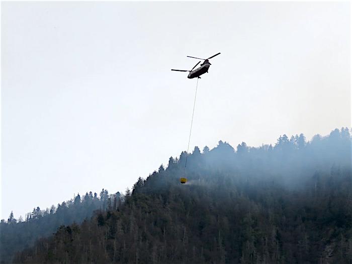
Helicopters were used Sunday to make water drops on the flames/NPS


Comments
Is Westgate Cabins on fire?
We are experiencing a conflagration event unlike any I have experienced in my life, and i've been through a few while living in Idaho.
I dont know the extent of things, and i'm sure it will start to trickle in once the sun comes up in the morning, but the chimney tops fire expanded RAPIDLY today and it seems to have burned about 20 square miles, or maybe more. Many structures in the town of Gatlinburg burned down, and many buildings along popular areas also have burned within the Gatlinburg-Pigeon Forge area. We had intense mountain wave winds that came in from a cold front and they averaged 45 to 85 mph, and this created a massive conflagration event. The fire blew up in about a six hour time frame.
I'm afraid in the morning, the devestation will be quite severe in many areas.
Praying for ya'll to be safe from the fires. Our family in Miami Florida loves the Gatlinburg area and the GSMNP.