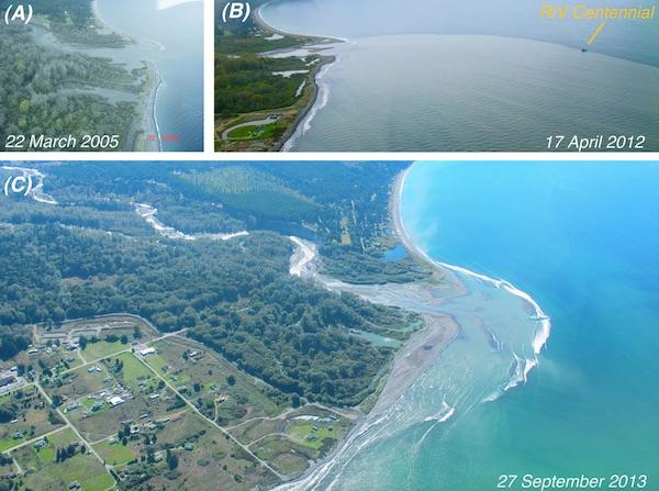
Aerial photos of the Elwha River mouth before and during dam removal. Photos show (A) the river mouth wetlands before dam removal, (B) the turbid coastal plume that occurred during much of the dam removal project, and (C) the expansion of the river mouth delta by sediment deposition/Photos provided by Ian Miller of Washington Sea Grant, Jonathan Felis of USGS, and Neal and Linda Chism of LightHawk
While cranes and other heavy equipment were the most visible tools used to dismantle dams holding back Olympic National Park's Elwha River, nature itself has proved to be a mighty force in aiding restoration of the rivershed from mountains to ocean.
For instance, since the Elwha and Glines Canyon dams were first breached two years ago, the Elwha River has moved the equivalent of roughly 3,000 Olympic swimming pools full of sediment that had been piled up behind the dams and pushed it all the way down to the Strait of Juan de Fuca. This sediment release -- which occurred even though river flows were relatively moderate, compared to historic flows -- altered the river's clarity and reshaped the river channel while adding new habitats in the river and at the coast, according to the U.S. Geological Survey. In fact, the vast majority of the new sediment was discharged into the coastal waters of the Strait of Juan de Fuca, where the river mouth delta expanded seaward by hundreds of feet, the agency said in a release.
'The expansion of the river mouth delta is very exciting, because we are seeing the rebuilding of an estuary and coast that were rapidly eroding prior to dam removal,' said USGS research scientist and lead author of the synthesis paper, Dr. Jonathan Warrick.
Overall, the effects of dam removal are better known as a result of several new studies released this week by government, tribal and university researchers. The scientists worked together to characterize the effects of the largest dam removal project in U.S. history occurring on the Elwha River. New findings suggest that dam removal can change landscape features of river and coasts, which have ecological implications downstream of former dam sites, the USGS said.
'These studies not only give us a better understanding of the effects of dam removal, but show the importance of collaborative science across disciplines and institutions,' said Suzette Kimball, acting director of the U.S. Geological Survey.
Five peer-reviewed papers, with authors from the U.S. Geological Survey, Reclamation, National Park Service, Washington Sea Grant, NOAA Fisheries, the Lower Elwha Klallam Tribe, and the University of Washington, provide detailed observations and insights about the changes in the river's landforms, waters and coastal zone during the first two years of dam removal.
Although the primary goal of the dam removal project is to recover spawning salmon runs to the pristine upper reaches of the Elwha River within Olympic National Park, the studies suggest that dam removal can also have ecological implications downstream of the former dam sites. These implications include a renewal of the sand, gravel and wood supplies to the river and to the coast, restoring critical processes for maintaining salmon habitat to river, estuarine and coastal ecosystems, USGS said.
'These changes to sediment and wood supplies are important to understand because they affect the river channel form, and the channel form provides important habitat to numerous species of the region,' said USGS research scientist and river study lead author, Dr. Amy East.
The final stages of dam removal occurred during the summer of 2014. Some sediment erosion from the former reservoirs will likely continue. The Elwha Project and research teams are continuing to monitor how quickly the river returns to its long-term restored condition.
The five papers can be found in Elsevier's peer-reviewed journal, Geomorphology, and they focus on the following topics of the large-scale dam removal on the Elwha River:
* Erosion of reservoir sediment


Add comment