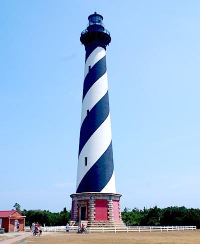
Climbing the Cape Hatteras Lighthouse offers panoramic views of the Outer Banks/Kurt Repanshek
Sun, salt spray, and sand are the main ingredients for a traditional Outer Banks vacation. Here on the North Carolina coast, where barrier islands bare the brunt of the Atlantic Ocean, families have been coming for decades to enjoy not only those aspects of summer but some of the best fishing along the Atlantic coast. The experience is so good that the National Seashore concept was born right here in 1937 when Congress authorized Cape Hatteras National Seashore.
Stretching more than 70 miles from Nags Head south to Ocracoke Inlet, the seashore draws those interested in history (during World War II the waters off the national seashore were thick with German U-boats that time and again targeted, and sank, unprotected merchant ships), surfcasting (fishing is particularly good in the fall when drum and bluefish are running), or simply flying a kite and enjoying the surf.
Towns that dot the seashore' Nags Head, Rodanthe, Salvo, Avon, Buxton, Frisco, Hatteras Village, and Ocracoke'are all popular destinations. So picturesque and romantic is Rodanthe that it was the backdrop for a 2008 movie starring Richard Gere and Diane Lane, Nights in Rodanthe. But the other towns are steeped in that seaside charm, too.
Visitors have a rich variety of activities to choose from: bird watching here along the Atlantic Flyway, shell hunting (winter and fall offer some of the best finds), fishing, of course, and solitude for early risers, late evening strollers, or simply walkers heading up or down the beach away from any crowds.
Campers have four campgrounds to consider'at Oregon Inlet, Frisco, Ocracoke, and Cape Point'and lighthouse lovers have three to admire' Ocracoke Light, Bodie Island Light, and Cape Hatteras Light (though access is only permitted to the last two).
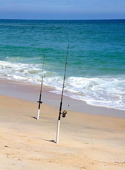
Surf fishing is one of the top draws to Cape Hatteras National Seashore/NPS
History fans will find the restored Chicamacomico Lifesaving Station of interest. Crews from that station gained fame in 1918 when they braved burning waters to save 42 from the Mirlo, a gasoline-carrying British steamship that hit a mine planted by a German U-boat. The explosion ignited a layer of gasoline atop the ocean waters. According to historical accounts, the men rowed their surfboat through a 'hellish environment that blistered paint on their boat, burned their skin, and singed their hair and clothing...'
If You Go
Plan far ahead to make lodging reservations, as Cape Hatteras has a deep and loyal following of vacationers. Spring and fall are the best times to fish; by the middle of summer fishing is best offshore. Winter fishing can be productive, but the weather is harsh and sometimes dangerous.
Winds that sweep across Pamlico Sound on the back side of the barrier islands produce excellent windsurfing and kite boarding. Many windsurfers and kite boarders use the Salvo Day Use and Haulover day use areas on Hatteras Island.
Ocracoke Inlet was the favorite anchorage of the notorious pirate Blackbeard (Edward Teach). Blackbeard was finally killed in a battle near there on November 22, 1718. His decapitated body was thrown overboard into the inlet.


Comments
Yup. I live in Alaska, not the eastern seaboard, but have been on many beaches in my day. I am very familiar with what ORV do to any ground surface, whether sand, dirt, snow bank, moss, or bird eggs.
People who make big footprints tend not to notice the toes of others under their boots.
Yeah it baffles me that he can't see what ORVs can do. First, if you have a leaky truck dripping oil, or antifreeze, that causes an effect on the environment, and to say that "no trucks are leaking any fluids on the beach is complete nonsense". Multiply that by thousands of vehicles, and you have some issues. Multiply that by 10s of thousands, then all the sudden it's beyond an issue. As I've stated, its amazing how much different cumberland island looks compared to Hatteras. Cumberland Island looks like it has a lot more vegetation, the dunes are a lot more uneven, and the ruts are no where to be found in many areas. Cape Hatteras looks wrecked in comparrison.
The gang here will be happy to know that more beach, tripling the size, closed in front the houses in Avon today. The least tern, a not federally listed species, is expected to take a month or two to fully fledge, starting at the height of the tourism season. You all should be proud that there will be a lot less foot prints on the beaches. A huge victory for your fight against human access and tourism.
If you plan on renting a house at Cape Hatteras National Seashore, be prepared to not have access to the beach in front your house. You'll need your big oil powered vehicle to search for beach access elsewhere.
LOL!
Um, Gary, I hate to ask, and I suspect Kurt wishes I wouldn't ask; but since you wrote:
What personal value of yours do you find threatened if the NPS fails to keep "mountain bike groups at bay"? Just curious.
Kurt, please delete this question if you perceive it's leading to another off-topic debate, as I think happened with the drones and LGBT articles.
The discussion of LGBT issues was on-topic for an article on LGBT issues.
I still don't get what a "national seashore" is, other than a national park with a coastline, which is still often named a national park (e.g., Channel Islands National Park).
I was hoping this article might provide more of an explanation behind the "concept" of a national seashore.
Hi, Rick B. — Right; but if I recall correctly, I think I was guilty of somehow slipping mountain biking into the LGBT discussion! :-)
As you say, Mr. Immtnbke.