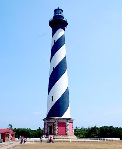
Climbing the Cape Hatteras Lighthouse offers panoramic views of the Outer Banks/Kurt Repanshek
Sun, salt spray, and sand are the main ingredients for a traditional Outer Banks vacation. Here on the North Carolina coast, where barrier islands bare the brunt of the Atlantic Ocean, families have been coming for decades to enjoy not only those aspects of summer but some of the best fishing along the Atlantic coast. The experience is so good that the National Seashore concept was born right here in 1937 when Congress authorized Cape Hatteras National Seashore.
Stretching more than 70 miles from Nags Head south to Ocracoke Inlet, the seashore draws those interested in history (during World War II the waters off the national seashore were thick with German U-boats that time and again targeted, and sank, unprotected merchant ships), surfcasting (fishing is particularly good in the fall when drum and bluefish are running), or simply flying a kite and enjoying the surf.
Towns that dot the seashore' Nags Head, Rodanthe, Salvo, Avon, Buxton, Frisco, Hatteras Village, and Ocracoke'are all popular destinations. So picturesque and romantic is Rodanthe that it was the backdrop for a 2008 movie starring Richard Gere and Diane Lane, Nights in Rodanthe. But the other towns are steeped in that seaside charm, too.
Visitors have a rich variety of activities to choose from: bird watching here along the Atlantic Flyway, shell hunting (winter and fall offer some of the best finds), fishing, of course, and solitude for early risers, late evening strollers, or simply walkers heading up or down the beach away from any crowds.
Campers have four campgrounds to consider'at Oregon Inlet, Frisco, Ocracoke, and Cape Point'and lighthouse lovers have three to admire' Ocracoke Light, Bodie Island Light, and Cape Hatteras Light (though access is only permitted to the last two).
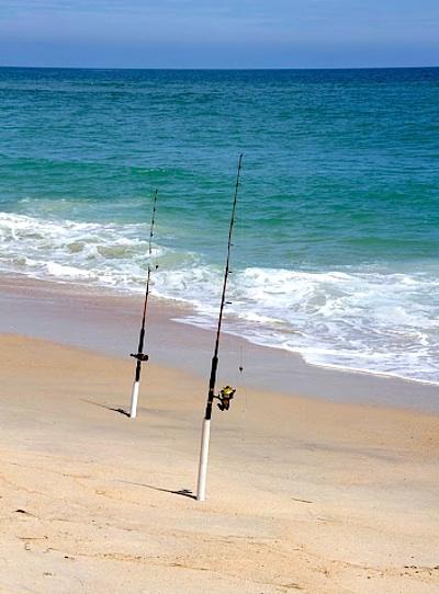
Surf fishing is one of the top draws to Cape Hatteras National Seashore/NPS
History fans will find the restored Chicamacomico Lifesaving Station of interest. Crews from that station gained fame in 1918 when they braved burning waters to save 42 from the Mirlo, a gasoline-carrying British steamship that hit a mine planted by a German U-boat. The explosion ignited a layer of gasoline atop the ocean waters. According to historical accounts, the men rowed their surfboat through a 'hellish environment that blistered paint on their boat, burned their skin, and singed their hair and clothing...'
If You Go
Plan far ahead to make lodging reservations, as Cape Hatteras has a deep and loyal following of vacationers. Spring and fall are the best times to fish; by the middle of summer fishing is best offshore. Winter fishing can be productive, but the weather is harsh and sometimes dangerous.
Winds that sweep across Pamlico Sound on the back side of the barrier islands produce excellent windsurfing and kite boarding. Many windsurfers and kite boarders use the Salvo Day Use and Haulover day use areas on Hatteras Island.
Ocracoke Inlet was the favorite anchorage of the notorious pirate Blackbeard (Edward Teach). Blackbeard was finally killed in a battle near there on November 22, 1718. His decapitated body was thrown overboard into the inlet.


Comments
I think wilderness needs to be set aside in more national parks, than just this one. I know there is a bill in place for Crater Lake, and they have a sliver of wilderness proposed at Cape Lookout National Seashore, but nothing has moved in congress. The only recent wilderness was at Pictured Rocks National Lakeshore, and a few years ago something like 95% of Rocky Mountain National Park became designated wilderness.. Getting wilderness set aside within National Parks helps keep the ORV and mountain biking groups at bay. The states of California, Colorado, and Washington were very proactive in creating wilderness in their National Parks
I think it's well past time to get National Seashores, along with Yellowstone, Glacier, Grand Canyon, Great Smokies, Crater Lake, and most of the parks in Utah wilderness.
Does Cape Hatteras or Cape Lookout even have a friends group? Seems like they need one. And then those groups can push for wilderness on both National Seashores and have more of a standing in fighting back the ORV hordes from destroying the landscape. Jeez, when I look at all the pictures from these seashores, and compare it to Cumberland Island or the Olympic Coast that has designated wilderness, it's like night and day. Cape Hatteras seems very denuded, and that's because of the ORV useage.
The Smokies is supposed to be managed as a wilderness area already so that formal designation is irrelevant.
Actually, that's not accurate. Managed as wilderness is a different designation than official wilderness that was designated and set aside by congress via the wilderness act. They could still techincally build the "broken promise" highway even if it's "managed as wilderness", if some superintendent came in and decided to approve it. They could approve single track bike tracks currently. If it was set aside as wilderness then it would take an act of congress to reverse the act, and the superintendents, as well as the park would have to follow different rules. In the west there are many "wilderness study areas". Just because those areas have "wilderness" in the name, doesn't mean it's managed like what it is in a designated wilderness. The parks without that designation can use ATVs, Chainsaws, and even vehicles to do trail maintence if they wanted, they can also build structures, which has been the case in Glacier (and yes like the Smokies it's managed as wilderness). In wilderness areas, that is not the case - the rules and legislation even in regards to the agencies that manage them must follow stricter rules and regulations for wilderness guidelines. There would be no use of chainsaws, no vehicles, and no building of structures in the wilderness zones.
From my experiences, the parks with designated wilderness are some of the wildest places in our country. I spent a lot of time in Craters of the Moon National Monument, and the wilderness has about a 3 mile trail, that then fades out, and from there you can trek 40 miles and not find another trail. Same goes with the Petrified Forest National Park, it's got about a 3/4 mile trail that is maintained, the rest of the wilderness you will be lucky to find evidence of human activity. Nothing else is maintained. You don't find many foot bridges in real wilderness areas, either. I can recall many hard stream crossings in wilderness areas in the west, and not a foot bridge, other than maybe a tree that fell over the creek that you use as a balance beam.
Is CHNSRA actually a National Park since it was not created under the authority of the Antiquities Act?
"I have hard time grasping that human access via foot, horse or ORV significantly modifies an area or invalidates 'primitive wilderness'."
We all know you do. The above is your words, beachdumb, with my emphasis.
You not knowing how an ORV could "modify or invalidate" wilderness is all the more reason why you should not be allowed to use them there. Joyride your toy around your own backyard for a while, and then bring in a stranger and see if they can identify where you were driving.
Antiquities act is for a president to declare an area a National Monument. Only congress has the ability to create a National Park, or a designated Wilderness Area..
In my humble opinion National Park Designated Wilderness > USFS, or BLM Designated Wilderness > National Park > National Monument in terms of protecting resources.
Rick, I am talking about beach sand, big difference, responsibly staying within designated trails, don't tell me these other "primitive wilderness" don't have trails or footpaths either.
The amazing thing about the beach is that with every storm the tracks are virtually erased. You should experience it one time, there are many ORV accessible National Seashores to do so.
Rick B
The entire beach from the toe of the dune as close as you want to the surf edge is an ORV trail. You can park on any part of it you want. In front of the ramps and in the more sought after fishing areas the ruts criss cross back and forth some 16" or more deep from the toe to the surf. Yep after a big storm a lot of it can be flattened back out until they are at it again. It is incredilious that Beachdumb can't see how that is a problem for others.