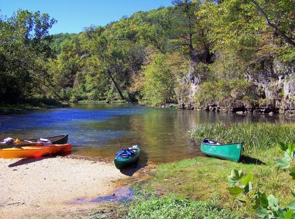
The Current (pictured) and Jacks Fork rivers that course through Ozark National Scenic Riverways in Missouri lure paddlers. Marty Koch photo.
A pitched battle is under way over the future of the Ozark National Scenic Riverways, one that goes to the heart of whether national parks are to be managed for the country's best interests, or for local interests.
At issue is the path the National Park Service is trying to chart for long-term management of the unit that was the very first in the nation designed specifically to protect a river system.
Proponents say the structure of the preferred alternative in the draft General Management Plan is long overdue and necessary to prevent further degradation of the 134 miles of the Jacks Fork and Current rivers that course through the rumpled, cave-studded, spring-gushing countryside of southern Missouri's Ozark Mountains.
Opponents, who include a freshman congressman from Missouri's 8th District, counter that the approach would convert "the vast majority of the park to a natural area where evidence of human use is minimal." From his perspective, U.S. Rep. Jason Smith maintains the park's preferred alternative would be devastating to area economies and continue what he sees as efforts by the Park Service to limit access to the forests and rivers within the National Riverways.
As with many of these debates in the National Park System, trying to filter the various viewpoints and rhetoric can be challenging. The debate at Ozark National Scenic Riverways is not unlike those at Cape Hatteras National Seashore in North Carolina, where the Park Service under court order implemented access restrictions to protect threatened shorebirds and endangered sea turtles, or at Point Reyes National Seashore in California, where the agency is mired in a legal battle over a commercial oyster operation in part of the seashore designated as official wilderness.
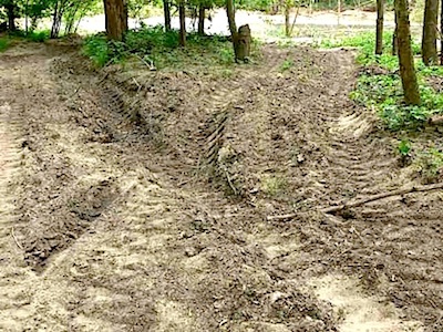
ATV damage can be found in many areas of the national riverways. Friends of Ozark Riverways photo.
National Park Service management in general has been pilloried by some in the wake of the 16-day closure in October of the National Park System due to Congress's inability to agree on funding for the federal government, perhaps creating an atmosphere among some to figuratively jump on the agency.
Rep. Smith portrays his attack on the agency over the Ozark National Scenic Riverways' draft general management plan as one over the economic and recreational well-being of his constituents. And in some aspects he appears to be forging a divide between Missouri residents who long have turned to the two rivers for recreation and livelihoods, and all Americans who hold a stake in how the National Park System is managed.
"Generations of Missourians in our congressional district have enjoyed the Jacks Fork and Current Rivers. The rivers are also the engine that drives numerous small businesses. When bureaucrats in Washington try to restrict land and river usage for families and businesses, our district suffers," the congressman, born nearly a quarter century after the national riverways was authorized, wrote in a weekly letter to constituents in mid-November.
He also took to the floor of the House of Representatives to voice his opposition to the draft GMP.
When the idea for an Ozark Rivers National Monument was discussed in 1960, the picture painted was one of a wild and ancient mountain range with a human history 10,000 years old and a unique geology, one plumbed by hundreds of springs that daily gush hundreds of millions of gallons of clean, cold water into the rivers. Red wolves once roamed here, while pileated woodpeckers flit about the hardwood forests.
Here would be an area preserved for use of people—an opportunity to float the Current or the Jacks Fork or the Eleven Point, to watch the osprey at work, to try camping on a gravel bar, to test the boater's or fisherman's skill, to watch the Ozarks renowned fall colors pass by, or perhaps even just to loaf. Hiking along the riverbank or to some remote cave, sink, or site where man of yesterday lived; wandering through little known Powder Mill Cave or into spectacular Jam Up Cave; climbing down a shaded trail to magnificent Greer Spring—all of these and many other opportunities would be available to the visitor. A carefully developed interpretive program would add to his enjoyment and understanding of the area.
Protecting these rivers seemed a central driver behind the creation of the National Riverways. The enacting legislation opens by stating that, "for the purpose of conserving and interpreting unique scenic and other natural values and objects of historic interest, including preservation of portions of the Current River and Jacks Fork River in Missouri as free-flowing streams, preservation of springs and caves, and management of wildlife, and provisions for use and enjoyment..."
But over the years park officials have grappled with that mandate. Rowdy boaters, drunken behavior, camping illegally on gravel bars, and the preponderance of unauthorized trails woven into the parkscape -- 65 miles of unauthorized horse trails, for example -- have challenged the staff. Indeed, a root of the uproar over the draft management plan that is open for public comment through January 8 can be traced to how the Park Service has managed, or in some views mismanaged, the National Riverways that was authorized in 1964 and officially dedicated in 1972.
"Frankly, enforcement has been the biggest problem over the past 30 years," said Lynn McClure, who as director of the National Parks Conservation Association's Midwest Office is studying the draft GMP and preparing comments on it. “It’s not an easy park to patrol. No. 1, it’s got a lot of linear miles to it on two sides of a river. You multiply that park boundary one way by two. It’s not easy to patrol.
"What’s happened I think over the last 30 years, the norm has become something that really wasn’t allowed at the park, in terms of what size of a boat you’re supposed to run on the river, in terms of pulling vehicles, cars, trucks, whatever into the middle of the river, onto the gravel bars and just parking," Ms. McClure said last week while discussing the draft document. "There are gravel bars where vehicle use or truck use is allowed, but it’s just become more common to just pull the truck out into the river."
The physical state of the Ozark National Scenic Riverways was detailed on the Traveler two years ago after it was named to American River's list of Most Endangered Rivers (a listing park officials took strong exception to). The portrait crafted by Susan Flader, who long taught in the University of Missouri-Columbia History Department and long followed and enjoyed the National Riverways, was of a unit of the National Park System taken over by locals, where all-terrain-vehicle traffic and no-holds horse use were exacting a toll on the natural resources both in terms of physical degradation as well as elevated E. coli levels in the river, according to Friends of Ozark Riverways.
"... the camping areas developed by NPS are all set back and screened from view from the river, while in the unofficial primitive sites anything goes, including slashing and mowing vegetation and reshaping banks to open the view and improve access to the river," Ms. Flader wrote at the time. "Moreover, the roads to them are not shown on any ONSR maps for general visitor use, meaning they are available only to those—mostly local residents—who have heavy duty vehicles or all-terrain vehicles (ATVs) and can find their own way there on a maze of unmarked, often deeply rutted roads. Local Ozark families have been visiting the river for generations, and they want to be in their own spot, right on the river, not in a developed campground with others."
None of this surfaces in Rep. Smith's condemnation of the Park Service planning efforts. His communications director, Justin Gibbs, told the Traveler on Monday that the congressman doesn't believe there's a need for more regulations in the National Riverways.
"The park is already over-managed, and we wouldn’t want to see any more restriction put on usages of any areas of the park," Mr. Gibbs said Monday during a phone call. “Our argument has always been that we can strike a balance here. We don’t have to shut the parks down in a way that’s going to make them accessible only to environmentalists. The parks should be accessible and they should be open. It’s public land.”
He pointed to the Park Service's proposal to seek creation of a 3,430-acre Big Spring Wilderness Area as one more step towards restricting access to the National Riverway.
When asked about problems with erosion caused by ATV travel and widespread equestrian use, as well as E. coli problems linked to horses, the congressman's spokesman said, "The folks who are using the parks are some of the best stewards of the land that you can imagine. This is their home. They want to do nothing but preserve and take care of it for their kids and their grandkids, and it’s just not right that their access should be limited.”
Still, Congressman Smith's comments have been described as carrying a measure of hyperbole as well as being off-mark.
One area resident, in a letter to the weekly Current Wave newspaper of Eminence, Missouri, questioned the congressman's facts, saying Rep. Smith was wrong in his claim that the national riverway was created "with the goal of preserving access to the Rivers."
"I don't recall that that was ever a goal," wrote Alan Banks. "There was never a problem with access to the rivers. The ONSR was created with a dual purpose, to preserve the natural beauty of the area and to provide recreational opportunities. Those purposes are often in opposition and it has been a continual conflict for managing the park. Should the park be a wilderness experience where people can enjoy unspoiled nature with minimal modern intrusions, or should it be an amusement park with unlimited numbers of canoes, high powered boats, ATVs, and horseback riders? I believe the Park Service has tried to strike a balance.
"I think most people would agree that the thing we love about the area and what attracts most visitors (on which local businesses depend), is its natural beauty. Would you rather come around the bend in the river and see a deer taking a drink or would you rather see someone's pickup backed out into the river with the radio blaring so everyone within sight can hear it? Would you rather see a heron fishing in shallow water next to a gravel bar or see tents and cars on what you expected to be an isolated area? The natural beauty is what we have to enjoy and what we have to sell to visitors and we need to be careful not to destroy that."
But in a countering letter, Jerry King, president of Voice of the Ozarks, voiced rhetoric similar to the one that has resounded throughout Cape Hatteras these past six+ years as the national seashore tried to come to terms with off-road vehicle use in habitat used by piping plovers, a threatened species, and five species of sea turtles, some of which are listed as endangered under the Endangered Species Act.
"The National Park Service, at the promoting of the Sierra Club and other environmental groups, wishes to turn a Scenic Easement into an Environmental Park inaccessible to everyone but environmentalists!" Mr. King wrote.
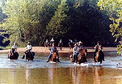
The Park Service wants to gain better control over horse crossings in the rivers. Friends of Ozark Riverways photo.
One thing about the Park Service's preferred alternative that draws criticism is the proposal to close and restore 65 miles "of undesignated horse trails and unauthorized stream crossings." Yet at the same time the park proposes to add roughly 25-35 miles of designated trails to the current horse trail system that runs about 23 miles, and create a 25-site horse campground along the Jacks Fork River.
In the process of addressing equestrian use in the riverways, the park would also prepare a "recreational horse use and trail management plan," something that's been missing. Park staff say this approach would better control erosion on river banks, soil compaction elsewhere, and sediment runoff.
The preferred alternative does state the Park Service's intention to gain control over motorized watercraft on the rivers, in part by increasing the percentage of river corridor open only to non-motorized watercraft (ie., canoes or kayaks). And the proposal aims to better manage camping on gravel bars by restricting to designated campsites where visitors could drive their vehicles.
The preferred alternative also would create "river management zoning," under which efforts to better manage motorized and non-motorized river use would be instituted. Under the plan, 34 percent of the Current and Jacks Fork rivers would be restricted to non-motorized craft, 14 percent would be open to motorized and non-motorized during the high season that falls between March 15 and Labor Day, and 52 percent would be open to both motorized and non-motorized traffic year-round.
"Establishment of river management zones that provide for nonmotorized stretches and stretches with increased management of horsepower and seasonal use would help reduce and control wake disturbances on riverbanks and associated erosion and sedimentation along several stretches of the rivers. However, since much of the proposed nonmotorized zones currently receive low levels of motorized use, the potential reductions in wake erosion in these areas would likely be minimal," park staff noted in the draft document.
As for other recreation, the Park Service wants to increase the amount of hiking trail access, in part by converting roughly 10 miles of roads in existing primitive zones to hiking trails. "One additional mile of accessible trails would be opened. Mountain biking would be a new, allowable trail use, but only on designated trails. Mountain biking would not be allowed in primitive zones," the plan adds.
Ms. Flader was hopeful the agency -- both in Washington, D.C., and locally -- would summon the backbone to adopt and enforce its preferred alternative.
“I think that they’ve made a real effort to grapple with the problems down there. I think that this is truly -- and this is my position -- has been a neglected park, where Park Service officials beyond those at the Riverways knew there were problems but just didn’t want to have to deal with it," she said Monday. "And now they have decided that they must deal with it. The Riverways is being watched by people in the Midwest Regional office, and in the Washington office. And they have, I am quite sure, have been looking carefully at this plan to see that it adheres to National Park Service standards. I think it’s gone back repeatedly for retooling of various things.”
A phone call to Gene Maggard, who owns the biggest canoe outfitting service operating in the Riverways, Akers Ferry Canoe Rental, was not immediately returned. But Ms. Flader, who has spoken with him repeatedly, thought he, too, was in favor of better management of the rivers.
"One of the things that is happening to those canoe outfitters, these concessionaires, is that there’s competition against them by other outftters who are not licensed, who are just dumping people into the river at other places, roads somewhere where it crosses the river," she said. "It makes it very difficult to distribute the use when that’s happening."
Furthermore, said Ms. Flader, “The easiest thing to complain about is the boarish, rowdy behavior of certain user groups. And that is the drunkenness and what not. The Park Service has actually done a good job of dealing with that in the last few years.
"...The canoe people don’t like it because their clients are suffering from it. Drunken guys standing out in the rapids and literally trying to tip canoes over as they come through, for fun."
Going forward, it will be interesting to see the tenor of comments received on this plan, and how the Park Service reacts. Should the riverways be a no-holds-barred recreation area, rife with miles of social trails, or one with regulations aimed at minimizing impacts with a goal of a better recreational experience? You can find the draft GMP, and comment on it, at this site.


Comments
If you provide the source of where I said that was the case? By the way, Missouri has a balanced budget as well - as do the vast majority of states.
I think they should have more say and currently don't have enough. And if I were you, I wouldn't be so confident that they won't get control of at least some federal properties.
"The fact Arkansas runs a balanced budget versus the massive deficit spending of the Feds also speaks volumes about "better stewardship"."
Hmmm - don't see anything about the Ozark National Scenic Riverways anyware in that sentence. Nor do I see you address that Missouri too has a balanced budget.
"The fact Arkansas runs a balanced budget versus the massive deficit spending of the Feds also speaks volumes about "better stewardship"."
Perhaps you need to go talk to your high school English teacher about contextual writing skills.
And may we see some documentation that Missouri and Arkansas have balanced budgets -- without Federal aid?
Lee - the fed doesn't have money on their own to give away. They take money from the people in the states and then give (some of) it back. It is the Federal government that is on aid.
Total payments Missouri to the Feds $48.4 billion in 2012.
http://en.wikipedia.org/wiki/Federal_tax_revenue_by_state
Total Fed contribution to Missouri budget 2012 $7.4 billion.
http://archive.oa.mo.gov/bp/pdffiles/2012presspacket.pdf
So tell me again how Missouri has federal "aid"?
I normally try to stay out the political aspects of these conversations as they bore me but really better stewards because they don't deficit spend. Can we stop with the troll like comments and just stick to things you know something about. Some folks consistently make specious arguments just trying to get a rise from people to discuss their pet govt theories.