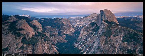
The National Park Service and xRez Studio have created one of the world’s largest photographic images, an amazingly detailed photographic map of Yosemite Valley. Seeing is believing, and believe me, you won’t need to squint!
Yosemite Valley, the heavily-developed visitor hub of Yosemite National Park, is a place of great beauty, but it is also a place where frequent rockfalls pose serious risks to people and property. Some of the more than 600 rockfalls documented since 1850 have injured or killed visitors. In October 2008, rockfalls below Glacier Point forced the closing of roughly one-third of the Camp Curry complex, significantly reducing the park’s supply of low-cost lodging.
To support their studies of Yosemite Valley rockfalls, geologists needed panoramic imagery of very large scale and very high resolution so they could, among other things, use repeat-image analysis (before-and-after views) of places where rock peeled off the valley walls. To do a proper job of it, the imagery would have to provide a seamless, highly detailed view of the many miles of cliff faces that rim the valley. In short, they needed a basemap that could only be produced by extreme panoramic imagery.
As Yosemite National Park geologist Greg Stock explains:
Every rock-fall event begins with the basic documentation: Where was it, how big was it, and why did it happen? Geologists have asked these questions about rock falls in Yosemite for the past 150 years, but now we’re doing it now with a precision that earlier scientists couldn’t have dreamed of. Sometimes these photos are the only way of ascertaining the location and size of the fall. We can immediately go to the photograph, zoom in on it and see what the mass of rock looked like before it failed. That can tell us a lot about why it failed.
A noteworthy advantage of extreme panoramic imagery is a substantial reduction in the risks that scientists and others must take when gathering detailed information about cliff faces.
Geologists typically would gather geologic data of rock faces by climbing cliffs, which poses obvious dangers not inherent in studying a photo from inside an office. The Yosemite imaging project creates an extremely detailed snapshot in time of present-day geologic conditions and allows for a detailed examination of the cliffs without having to climb them.
With help from the Yosemite Fund and many other partners, the Park Service worked with Los Angeles-based xRez Studio to produce just what the geologists needed. Technicians employed gigapixel panoramic photography in association with LiDAR-based digital terrain modeling and 3-D computer rendering to create a 3.8-gigapixel photographic map of Yosemite Valley. The 90,000 pixel-wide panoramic image gives geologists a tool of unprecedented quality and versatility. It's awfully big, too. If printed as a single photo, it would be 50 feet long.
To execute the intricate photographic process, technological devices took to land and air. Laser-mapping airplanes flew back and forth over the Valley collecting LiDAR (Light Detection and Ranging) data—creating a digital topographic model of the land’s surface. Then, on a single day in May 2008, photographic teams positioned themselves on the landscape to shoot images simultaneously to ensure uniform lighting. Each team produced 500 overlapping shots from a single vantage point, and these images were assembled into 20 high-resolution panoramas. These panoramas were then projected onto a one-meter resolution digital terrain model produced from the LiDAR data in 3-D rendering software. This graphic process unified Yosemite Valley’s walls into a vertical view that was then geographically corrected again for the two-dimensional photography’s limitations. In the final product: A map viewer gets the feeling of taking a 3-D computer flight over the Valley’s eight-mile width.
To read more about the Yosemite Panoramic Imaging Project, visit this site.
Viewing the project panoramic images is simple. Just visit the xRez Yosemite Extreme Panoramic Imaging Project site and click on Silverlight DeepZoom. (Viewing requires a download of the Silverlight HD plug-in to your browser.) Then choose the mini-photo of the panoramic view you’d like to view, zoom to various resolutions, and use your mouse to drag the view to wherever you want to go. You can even produce the sensation of flying over the terrain. Pretty neat, huh?
This extreme panoramic imagery is, of course, much more than just a tool for geologic research and eye candy for us Yosemite fans. The orthographic-elevational imagery can serve a wide variety of scientific, recreational, and other needs. For example, the park’s wildlife biologists can use the panoramic views to locate potential peregrine falcon habitat, search-and-rescue personnel can make detailed inspections of an area before initiating rescue operations, and recreational climbers can explore rock faces to study existing or potential climbing routes.
Postscript: Several rockfalls have occurred since the panoramic imagery basemap was created. These include the October 7-8, 2008, rockfalls from Glacier Point and the March 28, 2009, rock fall from Ahwiyah Point. Repeat photography of these areas delineated the rockfall source areas and enabled scientists to more precisely evaluate potential failure dynamics.


Add comment